
Utsjoki (North Sami: Ohcejohka) is the main village of the municipality with the same name, in northernmost Finnish Lapland. It is located beside the Teno river (Norwegian: Tana, Sámi: Deatnu) and the border to Norway.
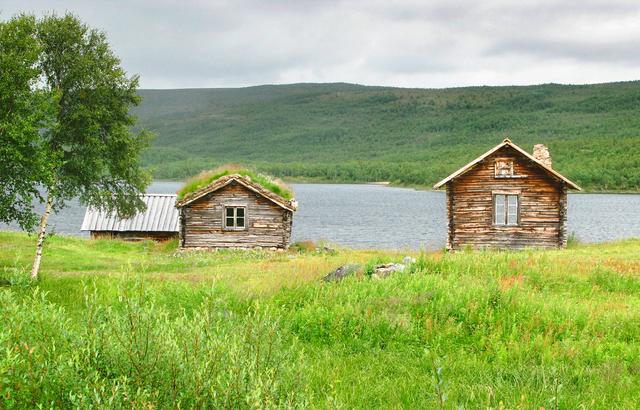
The municipality is very sparsely populated, with large wilderness areas. Virtually all the population lives in the valleys of river Teno and river Utsjoki and therefore most of the municipality is simply uninhabited. In addition, the population is concentrated into three villages: Utsjoki, Karigasniemi. and Nuorgam.. The rest of the villages you see on the map are just groups of a few houses.
About half of the population are Sámi and Utsjoki is the only municipality in Finland having Sámi speaking majority! Reindeer husbandry is important both culturally and economically but more traditionally people have lived from fishing salmon. Nowadays the border trade with Norway is the most important source of income as most things are cheaper in Finland than in Norway. Social ties across the border are common and many families have close relatives in Norway.
Tourism in Utsjoki is clearly concentrated to salmon fishing. The municipality is a summer destination with little activities in winter.
- Giisá village house, Utsjoentie 9, +358 40-822-8889. Tourist information, fishing permits, café and local handicrafts. Free Wi-Fi.
- Áilegas centre, Utsjoentie 46 c, +358 40-667-2229. Culture centre, with exhibitions, courses etc. Also the tourist office and the Metsähallitus information point.
- Tourist information, +358 40-181-0263.
The municipality is very sparsely populated, with large [[Hiking in the Nordic countries#Wilderness areas|wilderness areas]]. Virtually all the population lives in the valleys of river Teno and river Utsjoki and therefore most of the municipality is simply uninhabited. In addition, the population is concentrated into three villages: Utsjoki, Karigasniemi. and Nuorgam.. The rest of the villages you see on the map are just groups of a few houses.
The municipality is very sparsely populated, with large [[Hiking in the Nordic countries#Wilderness areas|wilderness areas]]. Virtually all the population lives in the valleys of river Teno and river Utsjoki and therefore most of the municipality is simply uninhabited. In addition, the population is concentrated into three villages: Utsjoki, Karigasniemi. and Nuorgam.. The rest of the villages you see on the map are just groups of a few houses.
Giisá village house, Utsjoentie 9, +358 40-822-8889. Tourist information, fishing permits, café and local handicrafts. Free Wi-Fi.
Áilegas centre, Utsjoentie 46 c, +358 40-667-2229. Culture centre, with exhibitions, courses etc. Also the tourist office and the Metsähallitus information point.
- Tourist information, +358 40-181-0263.
Áilegas centre, Utsjoentie 46 c, +358 40-667-2229. Culture centre, with exhibitions, courses etc. Also the tourist office and the Metsähallitus information point.
- Tourist information, +358 40-181-0263.
- The panorama of the Teno River.
- Saamen silta. The bridge over the Teno river was built in 1993. Before that the river was crossed by boat. Crossing the border to Norway you need to carry travel documents with you (and contact customs if you have something to declare) even though there is no active passport control.
- Northern Lights – Except in summer, when nights are light in Lapland, chances are good you'll be amazed by colourful curtains of Aurora borealis silently dancing high above you. The polar night starts in November and ends in January. During the polar night the sun doesn't rise at all.
- Utsjoki church and the Church Huts. Church built 1850–1853 at the site of one from 1700, parsonage from 1843. By the church is the old courthouse and church huts for Sámi arriving from far away.
- The King's Stone. Two stones with border marks from 1766 indicating the Strömstad border between the kingdoms of Sweden and Denmark. The stones carry king Adolf Fredrik of Sweden's monogram. The Strömstad Treaty (1751) for the first time defined an exact border between these countries this far north. free.
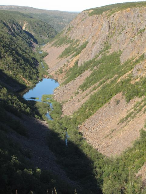
- Kenespahta Ice Falls. The ice waterfalls form every winter when the water runs off this nearly vertical drop down to Lake Kenesjärvi. Visible from road E75. free.
The panorama of the Teno River.
Saamen silta. The bridge over the Teno river was built in 1993. Before that the river was crossed by boat. Crossing the border to Norway you need to carry travel documents with you (and contact customs if you have something to declare) even though there is no active passport control.
[[Northern Lights]] – Except in summer, when nights are light in Lapland, chances are good you'll be amazed by colourful curtains of Aurora borealis silently dancing high above you. The polar night starts in November and ends in January. During the polar night the sun doesn't rise at all.
Utsjoki church and the Church Huts. Church built 1850–1853 at the site of one from 1700, parsonage from 1843. By the church is the old courthouse and church huts for Sámi arriving from far away.
The King's Stone. Two stones with border marks from 1766 indicating the Strömstad border between the kingdoms of Sweden and Denmark. The stones carry king Adolf Fredrik of Sweden's monogram. The Strömstad Treaty (1751) for the first time defined an exact border between these countries this far north. free.
Kenespahta Ice Falls. The ice waterfalls form every winter when the water runs off this nearly vertical drop down to Lake Kenesjärvi. Visible from road E75. free.
- Salmon fishing in the Teno river, the most important salmon river in Europe. As in salmon rivers elsewhere, this requires an easy to buy special permit in addition to the national fishing management fee. Check the procedures for disinfecting your fishing equipment. Note Norwegian requirements if crossing the border.
- Hiking in the surroundings, the Kevo Strict Nature Reserve or the Paistunturit or Kaldoaivi Wilderness Area. Information from Utsjoki nature information point (in summer) or Siida in Inari. Several trails start from the school centre. A map "Kevo Paistunturit" is recommended. It shows also the trails starting from the Utsjoki village. Kaldoaivi area is shown on a map "Kaldoaivi Sevettijärvi Nuorgam".
- Utsjoki geological trail (3.5 km)
- Kalkujoenlampi Trail (5.9 km circle trail)
- Utsjoki Hiking Trail (35 km as circle trail), mostly above the tree line in open fell areas, via Mantojärvi Church. Fairly popular. The highest point along the trail, Roavveoaivi (466 m), offers wide views, e.g. to the snowcapped Rastigaissa fell in Norway. For sleeping there is one open wilderness hut at Goahppelasjávri. On the trail you need to wade across the river Badjeseavttet.
- Kevo Hiking Trail (64 km) through the Kevo canyon in the Kevo Strict Nature Reserve to Sulaoja near Karigasniemi.
- Elli Trail (3.8 km), starts from the intersection at Lomatärppi holiday village
- Cross-country skiing in the wilderness areas in winter, challenging even for experienced skiers because of the sometimes very harsh conditions.
There is a swimming pool, a movie theater and even a disc golf park in the village.
[[Fishing in Finland|Salmon fishing]] in the Teno river, the most important salmon river in Europe. As in salmon rivers elsewhere, this requires an easy to buy special permit in addition to the national fishing management fee. Check the procedures for disinfecting your fishing equipment. Note Norwegian requirements if crossing the border.
[[Hiking in the Nordic countries|Hiking]] in the surroundings, the Kevo Strict Nature Reserve or the Paistunturit or Kaldoaivi Wilderness Area. Information from Utsjoki nature information point (in summer) or Siida in [[Inari]]. Several trails start from the school centre. A map "Kevo Paistunturit" is recommended. It shows also the trails starting from the Utsjoki village. Kaldoaivi area is shown on a map "Kaldoaivi Sevettijärvi Nuorgam".
- Utsjoki geological trail (3.5 km)
- Kalkujoenlampi Trail (5.9 km circle trail)
- Utsjoki Hiking Trail (35 km as circle trail), mostly above the tree line in open fell areas, via Mantojärvi Church. Fairly popular. The highest point along the trail, Roavveoaivi (466 m), offers wide views, e.g. to the snowcapped Rastigaissa fell in Norway. For sleeping there is one open wilderness hut at Goahppelasjávri. On the trail you need to wade across the river Badjeseavttet.
- Kevo Hiking Trail (64 km) through the Kevo canyon in the [[Kevo Strict Nature Reserve]] to Sulaoja near [[Karigasniemi]].
- Elli Trail (3.8 km), starts from the intersection at Lomatärppi holiday village
[[Cross-country skiing]] in the wilderness areas in winter, challenging even for experienced skiers because of the sometimes very harsh conditions.
People coming from the Norwegian side of the border usually head for the Alko store in Nuorgam to buy liquor, because it's far cheaper than in Norway. Tourists from elsewhere will most probably find some souvenirs more interesting.
- Uulan Säästö, Utsjoentie 1, +358 16 677 105. daily 09:00-20:00. The only grocery store around is actually quite large and sells about anything from screws to fresh meat. Fishing permits. Mail service. Some drugs. Alko pick-up point. Gasoline.
- Šiella, Utsjoentie 9, +358 40 822 8889. Sámi handicrafts.
Uulan Säästö, Utsjoentie 1, +358 16 677 105. daily 09:00-20:00. The only grocery store around is actually quite large and sells about anything from screws to fresh meat. Fishing permits. Mail service. Some drugs. Alko pick-up point. Gasoline.
Šiella, Utsjoentie 9, +358 40 822 8889. Sámi handicrafts.
- Restaurant Deatnu, Ellintie 25, +358 400 948 210. Weekdays 11:00–22:00, weekend 16:00–22:00.
- Annukan Grilli, Ringi 29, +358 40 760 2260. Normally 15:00–22:00, summer season 10:00–02:00. Hamburgers (incl. reindeer burger), reindeer kebab, and a famous reindeer stew.
- Pub Rastigaisa, Utsjoentie 4, +358 40 700 8154. weekdays 07:00–22:00, Fri 07:00–02:00, Sat 13:00–02:00, Sun 13:00–22:00. The only pub in the Utsjoki main village. Karaoke. Locals. Lunch 11:00–16:00. Pizzas in the evening.
Restaurant Deatnu, Ellintie 25, +358 400 948 210. Weekdays 11:00–22:00, weekend 16:00–22:00.
Annukan Grilli, Ringi 29, +358 40 760 2260. Normally 15:00–22:00, summer season 10:00–02:00. Hamburgers (incl. reindeer burger), reindeer kebab, and a famous reindeer stew.
Pub Rastigaisa, Utsjoentie 4, +358 40 700 8154. weekdays 07:00–22:00, Fri 07:00–02:00, Sat 13:00–02:00, Sun 13:00–22:00. The only pub in the Utsjoki main village. Karaoke. Locals. Lunch 11:00–16:00. Pizzas in the evening.
Postal code: 99980 Utsjoki
Mobile phones probably work well in the village and along the main roads, while there is no guarantee elsewhere. Be prepared to climb a fell if you need to make a call. For Teno, trails, cottages etc., check with your host or other locals.
- Other villages in the municipality:
- Nuorgam (Sami: Njuorggán), some 50 km north-east from Utsjoki, the very northernmost point of Finland – and of the European Union.
- Karigasniemi (Sami: Gáregasnjárga) in the south-west, 100 km on the way to Karasjok (and Kautokeino and Alta). Road 970 along Teno to Karigasniemi provides for a scenic ride, while most buses use E75 to Kaamanen and road 92 onward.
- Norway is just across the bridge over Teno. The municipality Tana has its centre downstream at Tana bru or "Tana bridge", which got its bridge already in 1948. The Arctic Sea opens in Varangerbotn about 80 km north-east from Utsjoki.
Other villages in the municipality:
- [[Nuorgam]] (Sami: Njuorggán), some 50 km north-east from Utsjoki, the very northernmost point of Finland – and of the [[European Union]].
- [[Karigasniemi]] (Sami: Gáregasnjárga) in the south-west, 100 km on the way to [[Karasjok]] (and [[Kautokeino]] and [[Alta]]). Road 970 along Teno to Karigasniemi provides for a scenic ride, while most buses use E75 to Kaamanen and road 92 onward.
Norway is just across the bridge over Teno. The municipality Tana has its centre downstream at [[Tana|Tana bru]] or "Tana bridge", which got its bridge already in 1948. The Arctic Sea opens in [[Varangerbotn]] about 80 km north-east from Utsjoki.