
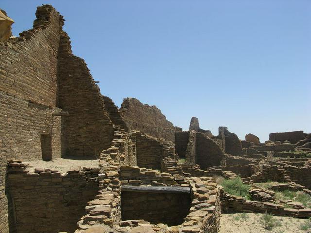
Chaco Culture National Historical Park is a major unit of the United States National Park System located within the Navajo Nation in northwest New Mexico. It preserves extensive ancetral pueblos of prehistoric American Indian communities. Chaco Canyon's largest pueblo, Pueblo Bonito, is on the UNESCO World Heritage List. For many years, people referred to the great houses in Chaco Canyon as ruins. Modern Pueblo Tribal members consider it more respectful to refer to the sites as ancestral pueblos. Tribal elders explain that Puebloan cultures moved from area to area to seek their place. Had the Spanish not arrived in the 1500s, it's possible, even likely that these sites may have once again been occupied. It is also preferred by the Pueblo Indians that the residents of Chaco Canyon and other ancestral villages be called "Ancestral Puebloans," rather than "Anasazi."
The Chaco dwellings were built and occupied primarily between about 850 and 1250 AD, during which time they were the hub of a remarkable network of transportation routes, many of which survive today as the "roads" of Chaco. They fell into disuse after 1300, probably due to climate change, although descendants of the Chacoans and other tribes remained aware of the ancestral pueblos. The present park was one of the first units of the National Park System to be formed specifically to protect archaeological resources, being first formed as Chaco Canyon National Monument in 1907 (shortly after Mesa Verde National Park, which also started as a national monument rather than a park). The monument achieved national-park status in 1980 and Pueblo Bonito became a UNESCO World Heritage Site in 1987.
Chaco is in canyon/mesa country, like most of northwestern New Mexico, but the topography in the park isn't as spectacular as in some other areas of the state; the visitor center, in the canyon bottom, is at an elevation of about 6200 feet, and the surrounding mesas rise only about 400 feet above this level. The canyon is wide and open for most of its length, unlike the narrow "slot canyons" to the northwest in Utah. This, of course, is why there's a park here: the openness of the canyon provided enough room to build the pueblos and grow crops. Note that this elevation is high enough to challenge the lungs of the visitor freshly up from sea level. You may find yourself a bit short of breath when hiking, so if you're going to be there overnight, it's recommended that you do the "easy" trails along the main loop first to get acclimatized somewhat, then the longer, more vertical backcountry trails on your second day.
Most of the rock comprising the mesas as well as the canyon floor is sedimentary, and consequently tends toward flat bedding planes that are interrupted by relatively few faults and folds. As a result, one of the hiking challenges is that the transition between individual geological formations along the canyon walls can be steep. This is incentive to stay on the constructed trails in the backcountry; you'll want to do that anyway, as off-trail hiking is generally prohibited and the prohibition is enforced.
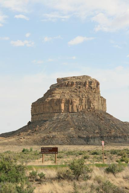
One of the signature features of Chaco is Fajada Butte near the south entrance. This narrow, steep-walled butte rises about 400 feet above the canyon and is notable for artifacts including the "Sun Dagger," verified by Anna Sofaer as an astronomical observatory/clock used by the Chacoans to predict and document the solstices, equinoxes, and the approximately 18.5 year lunar cycle. Dr. Sofaer's research is available at www.solsticeproject.org. This website, in particular, is a must for visitors who wish to inform themselves before the magical experience of a Chaco visit. Fajada Butte is no longer open to hikers, but a roadside turnout near the south entrance leads to a viewpoint from which it can be seen and photographed to good advantage. Early morning and late afternoon are the best times to photograph Fajada.
Chaco has high-desert flora, with sagebrush, cactus, etc., interspersed with small bits of piñon/juniper scrub forest, the latter primarily on the mesa tops. Chaco receives less precipitation (average 8 inches per year) than some other parts of New Mexico at similar latitude and elevation, and consequently does not have the coniferous forest of some areas to its east. Plant life is generally sparse.
Animal life too is not as abundant as elsewhere in the state, but wildlife encounters are still reasonably frequent. The largest animal you're likely to see is the ubiquitous coyote, although you may also see a deer or two. Elk and antelope are present in the region but rarely encountered in the park. Smaller carnivores such as bobcat, badger, fox and two species of skunk are sometimes seen, and rodents are locally abundant, with a few prairie-dog towns in the park. Small colonies of bats are present during the summer.
The shortage of water reduces the prevalence of bird life as well, but Chaco is still an island of at least relative avian abundance and diversity in this region. With luck you'll see a roadrunner or two, but don't count on it; they're rare here. The usual assortment of medium to large hawks (Cooper's hawk and kestrel are fairly common), owls (more often heard than seen), vultures and raven are present, if less abundant than in the mountains to the east. There are reasonably large populations of smaller birds, with warblers, sparrows, house finches, etc., common. Three species of hummingbirds are at hand, and one of the treats of late summer is watching the tiny but incredibly pugnacious rufous hummingbirds chasing off the larger, mellower black-chinned hummers that compete with the rufous for habitat. It's like watching a World War I aerial dogfight in miniature. Rufous hummers are rare in the park, however, and you'll be lucky to get this visual treat.
Western (prairie) rattlesnakes are occasionally seen in the backcountry, but you're much more likely to see various lizards scurrying along the tops of restored walls of structures, with skinks being fairly abundant.
Chaco, like most of northwestern New Mexico, has a high desert climate with four distinct seasons. Spring is dry and windy, with high temperatures rising rapidly from an average of or so in March to over in June. Summer is hot, with highs frequently above, and with much of the average year's precipitation falling in isolated, brief but violent thunderstorms. However, it's the legendary "dry heat" that doesn't feel nearly as hot as in regions with higher humidity. Cooling starts in August and leads to a dry, temperate fall season that is usually a good time to visit Chaco. Winter is also pleasant with highs around and clear skies, although there are usually three or four frontal storms each winter that bring snow, usually in small quantities but with the occasional major snowstorm. The remoteness of the park is such that it's a good idea to check a weather forecast before visiting in the winter; Farmington, about 60 miles (100 km) away, usually experiences similar weather, and its current conditions and forecast are updated regularly. If there's significant snow (say 6 in/15 cm or more) in the forecast, it's wise to defer your trip unless you're particularly well prepared for snowy roads.
Entrance fees for the park are $4 for individuals, $8 for cars, and are good for seven days.
Campsites (see below under "Sleep") are $10/night, with a $5 discount for holders of a Park Pass. Permits are required for backcountry hiking. They're free and available at the visitor center, or at the trailheads.
While there is a visitor center with exhibits (open 9AM-5PM except major holidays), the park's trademark attraction is the collection of major ancestral pueblos along the loop road in the canyon bottom. Some can be seen from the car, but more rewarding is to follow the short, easy trails at each that lead to and through the pueblos. Pamphlets explain the important features of the sites. The site trails are open from sunrise to sunset; visiting with the sun near the horizon yields particularly appealing opportunities for photography.
There are four trails leading to remote pueblos, all available for day use and closed after sundown. Probably the most interesting is the trail to Peñasco Blanco pueblo, which has become famous for a well-preserved pictograph thought by some to represent the great supernova of 1054. This pictograph is under a rock alcove below the main Peñasco Blanco structures. Please treat it respectfully; this is a rare find in the world of anthropology. This trail crosses a wash that can be dangerously full of water if there have been thunderstorms upstream.
All trails require free permits available at the visitor center or the trailheads. Hiking boots are a good idea, and carry plenty of water. Off-trail hiking is generally not allowed.
Bicycling is a good way to get around the main tourist loop, and in addition, there are two backcountry trails that offer mountain biking. Wijiji trail is shared with hikers and is a short (about 3 miles), easy ride that should take under an hour. A more serious undertaking is the ride to Kin Klizhin, an "outlier" site archaeologically related to the main canyon sites but well removed from the canyon itself. The ride to Kin Klizhin takes one southwest out of the canyon and into some very lonely country, and is about a 25-mile (40 km) round trip. Go well prepared with water, repair kit, etc.
The exceptionally dark night skies of Chaco provide good opportunities for amateur astronomers who bring their own telescopes, but even better, in 1998 the park opened its own observatory with a large (25") telescope and modern equipment that the visitor can share. During the summer there are interpretive programs by park staff, supplemented by members of The Albuquerque Astronomical Society who bring equipment, give lectures, etc. Information on the program may be available at the Society's web page, but the Chaco information does not appear to have updated since 2004.
Most of the major Chaco pueblos are photogenic, but a few tips to improve your chances of getting some good shots:
- These ancestral pueblos are known as great houses, and they are massive. Wide-angle lenses are useful.
- Many of the "commercial" shots that you see are difficult for the average traveler to duplicate, because you're required to stay on the trails (and the requirement is enforced), limiting your opportunities to get shots from above. Views of the Pueblo Bonito and Chetro Ketl sites are reached by trails that do lead to vantage points above the ancestral pueblos, and are therefore better suited for this kind of shot than some others.
- As in many such sites, photographs taken during the middle of the day can look somewhat flat, particularly in the height of summer. Plan on using your camera at sunrise and sunset if feasible. Fajada Butte, one of the park's iconic features, is particularly attractive at such times, with shadows that create interest.
- You'll have a hard time incorporating much green and growing vegetation into your shots, but the vegetation, such as it is, is most photogenic early in the spring (if there's been some snow) and again early in the fall.
As in many such sites, photographs taken during the middle of the day can look somewhat flat, particularly in the height of summer. Plan on using your camera at sunrise and sunset if feasible. Fajada Butte, one of the park's iconic features, is particularly attractive at such times, with shadows that create interest.
The visitor center includes a small gift shop and (very good) book store. For more elaborate memorabilia, stop in one of the towns you passed through on the way in, or if you're fortunate enough to be there at the time of a Navajo rug auction in nearby Crownpoint, give it a try (see under "Get out").
You'll have to bring your own food, as there is no food service at Chaco. Farmington/Bloomfield/Aztec, Gallup, and Grants, at least one of which you'll have to pass through en route to the park, have the usual restaurants and grocery stores. Crownpoint, the town nearest the park, has very basic food service.
There's no night life at the park; that's why it's there. The nearest town with any night life is Farmington. Note that alcoholic beverages in any form are prohibited within the Navajo Nation, which occupies the area immediately west of the park.
There are no significant safety issues with the park itself (usual warnings about wildlife, sunscreen, etc.), but its remoteness means that you may want to pay a little extra attention to road safety while getting there and back. Northern New Mexico is notorious for problems with drunk drivers. Areas near Navajo Nation, as Chaco is, are particularly worrisome, as the prohibition of alcohol on the reservation causes residents to drive into Farmington or Gallup to indulge. Terrible accidents have happened involving Navajo Nation citizens on the way home after an evening of drinking; be extra cautious at such times.
Be alert also for livestock on the roads, particularly sheep. It's wise to fill your gas tank in Farmington or Gallup (or Grants or Thoreau) before heading for the park, as services are sparse indeed once you get off the main roads.
Weather conditions and hydration cannot be adequately emphasized. Every year there are rescues of visitors who are improperly prepared for either. From June to October, the Four Corners region is subject to violent afternoon and evening thunderstorms called "monsoons," or by the Navajo, the "male rains." The storms build quickly and can be preceded by strong winds, even into the 40-60 mile per hour range. Tents should always be tied with guy wires, and care must be taken ensuring the tent is not located in even the smallest of drainage courses.
It is safest to hike to isolated areas in the morning with the activity timed to return before mid-afternoon. When hiking during Monsoon season, carry a poncho or other rain gear. Take shelter and avoid trees or outcroppings because of lightning. If caught in a storm, if a feeling of hair raising or tingling is felt, crouch low to the ground, stay out of puddles, and try to keep your body from direct ground contact. Balance by holding on to your shoes. At your campsite, the tent is the safest shelter.
In terms of hydration, carry four to five liters of water when on one of the wilderness hikes. Anything less can be deadly. Drink before you feel thirsty. Set a rhythm where regular "swigs" of water are part of the hike. Even when visiting the "accessible" abandoned pueblos, it makes sense to carry at least a liter and to hydrate regularly. A good ratio is one liter of an electrolyte-filled drink to three liters of water. Consuming exclusively water can dilute eletrolytes and create a deadly body condition. For best results, use electrolytes that have little or no sugar or other sweeteners.
- Navajo Nation lies just west of the park, with numerous related attractions. If you happen to be there on a Friday, a Navajo rug auction at Crownpoint combines well with a visit to Chaco. Rug auctions are "usually ... but not always" on the third Friday of the month; check the Crownpoint Rug Weavers Association's web site to be sure. Crownpoint rug auctions are a fascinating cultural study even if you're not in the market for a rug.
- Aztec Ruins National Monument is another NPS unit full of historical, cultural and archaeological interest; near the town of Aztec just east of Farmington.
[[Navajo Nation]] lies just west of the park, with numerous related attractions. If you happen to be there on a Friday, a Navajo rug auction at Crownpoint combines well with a visit to Chaco. Rug auctions are "usually ... but not always" on the third Friday of the month; check the Crownpoint Rug Weavers Association's web site to be sure. Crownpoint rug auctions are a fascinating cultural study even if you're not in the market for a rug.
Aztec Ruins National Monument is another NPS unit full of historical, cultural and archaeological interest; near the town of Aztec just east of Farmington.