
Käsivarsi Wilderness Area in the "arm" of Finland is the most popular of the wilderness areas in Finnish Lapland. It features all of the peaks above 1000 m in the country, except the nearby Saana. It borders to Reisa National Park in Norway.
Like the other wilderness areas Käsivarsi was established in 1991, but it had been a popular destination long before (a hostel in nearby Kilpisjärvi was built 1937, a hotel 1948). With its 2206 km² it is the second largest of the areas.
The area has probably been inhabited since soon after the ice sheet of the Ice Age withdraw. There was fish in the rivers, reindeer in the fells, other game, and plants and berries in the summer. Stone age dwelling sites have been found. Pieces of earthenware from 4500 BC have been found by Lake Kilpisjärvi.
Tamed reindeer have been used for two thousand years, but large scale reindeer husbandry was introduced in the area in the 17th century and remains important. Some Sámi families still live in the Raittijärvi Lapp village (with no road connections) for most of the year.
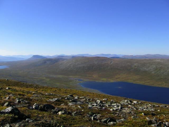
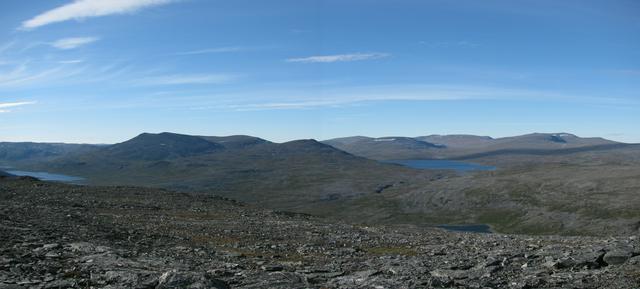
Many fells in the Käsivarsi area belong to the Scandinavian mountain range, in contrast to fells in the rest of Finland. Most of the area – more or less all the northern part – is above the treeline.
Fauna includes lemming, root vole, grey red-backed vole, least weasel, stout, red fox, Arctic fox, lynx, wolverine – and of course reindeer. Wolves and bears sometimes visit the area. 89 species of bird nest here, including peregrine falcon, snowy owl and lesser white-fronted goose, but only few stay all year, such as willow grouse, rock ptarmigan, gyrfalcon, willow tit and Siberian tit.
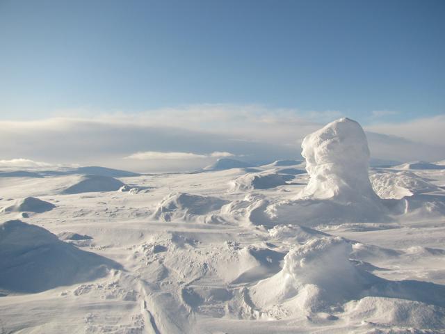
The climate is harsh. The area is at quite high elevation much north of the polar circle. Weather can change drastically in little time. Snow and freezing temperatures are possible also in midsummer. Above the treeline there is little natural shelter against storms.
There is polar night for about two months in winter and midnight sun most of the summer.
The peak seasons are in August and April, the latter by ski.
Right to access is applicable (there may be some restricted areas, like the Annjalon nature reserve). Hiking and overnight stays in tents and open wilderness huts are free. You have the permission to make fire from fallen branches and wigs on the ground, unless near a fireplace (use that instead) or if a wildfire warning is in effect, but firewood is sparse and lighting campfires is not recommended.
Beds in reservation huts cost €11/person/night. Prices of rental huts and cabins vary, the huts €70 or €220/day (4–8 persons).
If you intend to fish you can buy the permits at the nature centre (or a local business helping with arrangements). Angling and ice fishing is free in most lakes, but forbidden in flowing water. In the lakes Toskaljärvi, Luohtojärvi and Peeran lammet you need a local permit. For lure and fly fishing you need the national permit and one of two local permits depending on area: Lätäseno (nr 1550) or Enontekiö (nr 1551), the latter including ice fishing and angling in the above mentioned lakes. Equipment (including boots) should be disinfected, e.g. by sufficient drying, if moving between waters with and without the Salmon parasite Gyrodactylus salaris. Check details at the visitor centre.
To hunt (willow grouse and northern hare) you need a permit for "hunting area 1613 Käsivarsi", which can be bought at the visitor centre in Hetta. You also need general hunting and arms permits.
To use the snowmobile tracks you need to pay a fee, possibly separately for Metsähallitus tracks and the track network of local businesses.
- The wild barren landscape has a special charm. The main sight for the Finnish is the Halti. (Sámi: Hálde) fell, some 55 km from Kilpisjärvi. The highest point in Finland (1,365 m) is at a border mark on the fell side. There is a guestbook to sign. Ridnitšohkka peak (1,317 m) close by is the highest peak in Finland and some other of the highest fells of Finland are in sight.
- Pihtsusköngäs Falls. (Pihtsuskordsi), 17 m high, some 45 km from Kilpisjärvi along the Nordkalottleden trail.
- Toskaljärvi cave. A cave with an underground stream through paleotsoic dolomite, thought to be about 150 m long. Exploring the cave is dangerous because of the water.
- Palsa bogs, i.e. bogs with frost mounds.
- Prehistoric trapping pits at several locations. The deep and wide pits were dug in chains along reindeer routes. Now they are much more shallow, but with some imagination you may be able to reconstruct the hunt.
The wild barren landscape has a special charm. The main sight for the Finnish is the Halti. (Sámi: Hálde) fell, some 55 km from Kilpisjärvi. The highest point in Finland (1,365 m) is at a border mark on the fell side. There is a guestbook to sign. Ridnitšohkka peak (1,317 m) close by is the highest peak in Finland and some other of the highest fells of Finland are in sight.
Pihtsusköngäs Falls. (Pihtsuskordsi), 17 m high, some 45 km from Kilpisjärvi along the Nordkalottleden trail.
Toskaljärvi cave. A cave with an underground stream through paleotsoic dolomite, thought to be about 150 m long. Exploring the cave is dangerous because of the water.
Palsa bogs, i.e. bogs with frost mounds.
Prehistoric trapping pits at several locations. The deep and wide pits were dug in chains along reindeer routes. Now they are much more shallow, but with some imagination you may be able to reconstruct the hunt.
See Hiking in the Nordic countries for general advice.
Nature trails outside the wilderness area proper:
- 500-m nature trail to the Iitto mire reserve, with palsa bogs, i.e. bogs with frost mounds. Start at E8 50 km south of Kilpisjärvi.
- 5-km nature trail from Kilpisjärvi showing nature at the west side of Saana
- 8–12 km nature trail leading from Kilpisjärvi to the top of Saana and back, optionally via a day hut.
Shorter hiking trails, mostly outside the wilderness area proper:
- Hiking trail Tsahkaljärvi–Saanajärvi–Saana
- Salmivaara Trail (2 km)
- Hiking trail to Ailakkajärvi (11 km). The trail goes mostly above the tree line. Start at Peera. by E8, some 10 km south of Kilpisjärvi. The trail is not necessarily marked, but there are paths you can follow with a map and some skill. If you want to extend the hike, you could continue to Termisjärvi wilderness hut some 11 km away (considerably longer if you want to climb Dierpmesvárri) and return by the 16-km path to Kilpisjärvi (more or less the same route as the snowmobile track).
- Hiking trail through Malla strict nature reserve to the tripoint 11 km away. Boat transport either way possible. The trail continues as the Nordkalottleden through Norway and Sweden.
Otherwise you are probably here for some serious wilderness backpacking, in winter and spring by cross-country skiing. The most popular trails are those to Halti (along Nordkalottleden; about 3000 persons a year), but there is no need to keep to the marked trails. You can get a guide from local businesses.
Trails via Halti:
- Kilpisjärvi–Halti–Kilpisjärvi (108 km)
- Kilpisjärvi–Halti–Lossujärvi–Didnujoki–E8 (87 km), not marked all the way; keep north of Vuomakasjärvi and the other waters, the bridge over Vuomakasjoki on some maps does not exist
- Kilpisjärvi–Halti–Kautokeino (190 km), some difficult passages at high waters
Hiking trail to Ailakkajärvi (11 km). The trail goes mostly above the tree line. Start at Peera. by E8, some 10 km south of Kilpisjärvi. The trail is not necessarily marked, but there are paths you can follow with a map and some skill. If you want to extend the hike, you could continue to Termisjärvi wilderness hut some 11 km away (considerably longer if you want to climb Dierpmesvárri) and return by the 16-km path to Kilpisjärvi (more or less the same route as the snowmobile track).
- Poroeno–Lätäseno River Route. A challenging route for experienced paddlers (265 m/100 km). The route starts in the middle of the wilderness area, which means you first have to get the canoe there (or somewhere along the route). The first third has most of the altitude drop (130m/30km). The route is not suitable at high or low waters (you can get advice at the visitor centre). There are several open wilderness huts along the route. Free, if you have own equipment and transport.
Poroeno–Lätäseno River Route. A challenging route for experienced paddlers (265 m/100 km). The route starts in the middle of the wilderness area, which means you first have to get the canoe there (or somewhere along the route). The first third has most of the altitude drop (130m/30km). The route is not suitable at high or low waters (you can get advice at the visitor centre). There are several open wilderness huts along the route. Free, if you have own equipment and transport.
Several businesses in Kilpisjärvi arrange snowmobile safaris, which may include a visit to Halti, ice fishing or watching polar lights.
Metsähallitus calls the area a fishing paradise. Typical species are Arctic char, grayling, trout, whitefish, perch and pike. Fishermen usually either go on a shorter arranged fishing tour, arrange transportation to a rental hut or cottage, or hike to the fishing grounds.
Angling and ice fishing in lakes are Everyman’s rights, except where fishing is restricted. For lure and fly fishing you need the national and local permits.
Hunting willow grouse and northern hare is allowed in the area, given the needed permits.
There are shops in Kilpisjärvi., Kaaresuvanto./Karesuando, Kautokeino. and Skibotn.. Some souvenirs are sold at the visitor centres.
There are shops in Kilpisjärvi., Kaaresuvanto./[[Karesuando]], Kautokeino. and Skibotn.. Some souvenirs are sold at the visitor centres.
There are shops in Kilpisjärvi., Kaaresuvanto./[[Karesuando]], Kautokeino. and Skibotn.. Some souvenirs are sold at the visitor centres.
There are shops in Kilpisjärvi., Kaaresuvanto./[[Karesuando]], Kautokeino. and Skibotn.. Some souvenirs are sold at the visitor centres.
There are shops in Kilpisjärvi., Kaaresuvanto./[[Karesuando]], Kautokeino. and Skibotn.. Some souvenirs are sold at the visitor centres.
There are gas or wood heated stoves in the wilderness huts, which make for the easiest cooking, but in season the huts may be crowded and the distances between huts are sometimes long.
There is not much firewood, so relying on open fire for cooking is unwise. Firewood meant for use in the huts should not be taken for use at campfires. A portable stove is recommended.
Good looking water in the area should be safe, but in periods with warm weather boiling it is recommended.
Do not go without a guide or sufficient experience. Do not go alone or without proper clothing and equipment, including good maps. Know how to handle adverse weather and loosing your way.
Tell about your plans (e.g. to the nature centre) and give a hard deadline, when emergency services should be called unless you have announced your return or told about being belated. Sign guest books in the huts on your route, noting any changes in your plans.
Some areas are without mobile phone signal. Try high and open ground. Keep the phone guarded against moisture and off most of the time.
You will have to wait for quite a while for any help. Be prepared to help yourself as much as possible. Do not forget first aid equipment.