
La Gomera is the second smallest island of the Canary Islands.
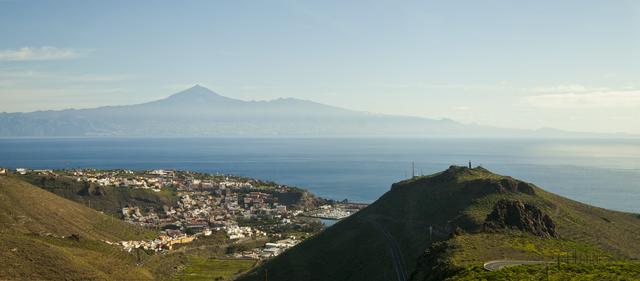
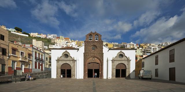
- San Sebastián de La Gomera. A very civilized capital and main port – the ferries from Los Cristianos arrive here. A good base for walking as all the local buses leave (starting at 10.30am) from the bus station to the villages of La Gomera. Columbus set sail from here. It has several nice black sand beaches and some historic buildings like the Count's Tower or the Church of La Asunción. Throughout the years it has grown over the hills and inside the valley.
- Agulo. Compact small town divided in two parts by Hermigua, it is surrounded by massive mountains. It has a charming town center and great views to Tenerife. On the rainy season you can get to see waterfalls from each mountain.
- Hermigua. The first stop of the north route departing from San Sebastián. Formerly a wealthy agricultural valley, it still has many banana and exotic fruits plantations, and due to this bucolic landscape it now has become a destination for exclusive travelers. The town is stretched out down the valley. It features the island's only natural swimming pool, several charming beaches with views to Tenerife and is a great trekking base to discover Garajonay National Park and the island's green north due to it's proximity to San Sebastián and El Cedro Forest.
- Playa de Santiago. Small tourist resort dominated by large hotel complex owned by Fred Olsen, the ferry company. Formerly a fishing port with a canning factory, it has become the island's second largest touristic area thanks to the large hotel Tecina. The island's only golf course sits here.
- Valle Gran Rey. Main tourist resort, thanks to its beaches. Formerly a hippie hangout retaining an alternative feel in places. It is located in the westernmost part of the island. It's named after the "Great King", who ruled for a brief period over all the kings of the island.
- Vallehermoso. A small town, it is the last stop of the northern route. Its symbol is the Cano Rock, the largest eroded volcano chimney remaining in the island. As Hermigua and Agulo, it has evolved from agricultural-based economy to a slow tourism destination linked to trekking.
San Sebastián de La Gomera. A very civilized capital and main port – the ferries from [[Los Cristianos]] arrive here. A good base for walking as all the local buses leave (starting at 10.30am) from the bus station to the villages of La Gomera. Columbus set sail from here. It has several nice black sand beaches and some historic buildings like the Count's Tower or the Church of La Asunción. Throughout the years it has grown over the hills and inside the valley.
Agulo. Compact small town divided in two parts by Hermigua, it is surrounded by massive mountains. It has a charming town center and great views to Tenerife. On the rainy season you can get to see waterfalls from each mountain.
Hermigua. The first stop of the north route departing from San Sebastián. Formerly a wealthy agricultural valley, it still has many banana and exotic fruits plantations, and due to this bucolic landscape it now has become a destination for exclusive travelers. The town is stretched out down the valley. It features the island's only natural swimming pool, several charming beaches with views to Tenerife and is a great trekking base to discover Garajonay National Park and the island's green north due to it's proximity to San Sebastián and El Cedro Forest.
Playa de Santiago. Small tourist resort dominated by large hotel complex owned by Fred Olsen, the ferry company. Formerly a fishing port with a canning factory, it has become the island's second largest touristic area thanks to the large hotel Tecina. The island's only golf course sits here.
Valle Gran Rey. Main tourist resort, thanks to its beaches. Formerly a hippie hangout retaining an alternative feel in places. It is located in the westernmost part of the island. It's named after the "Great King", who ruled for a brief period over all the kings of the island.
Vallehermoso. A small town, it is the last stop of the northern route. Its symbol is the Cano Rock, the largest eroded volcano chimney remaining in the island. As Hermigua and Agulo, it has evolved from agricultural-based economy to a slow tourism destination linked to trekking.
Undeveloped, unspoilt, beautiful island just 40 minutes by fast ferry from Tenerife. Ideal for walkers. Contrast between lush forests around the summit and in the national Park with dry vegetation on the flanks of the island. Of real interest to botanists for its variety of plant life and number of endemic species. Good climate all year round, especially in the south. La Gomera is one of two Canary Islands without direct tourist flights from mainland Europe, the other being El Hierro.
Spanish is the main language. English is widely understood in Valle Gran Rey, where German is easily the second language after Spanish. Most menus are printed in three languages. Famous for El Silbo - whistling language which was used to communicate across the deep valleys. The local council are trying to revive El Silbo; it is now a compulsory (and popular) subject in schools on the island.
- El Castillo del Mar. Former loading station (mostly for bananas), restored and turned into a venue by long-time resident German photographer. Has intimate atmospheric concerts, with the sound of the waves in the background
- Los Organos cliff. Striking basalt columns, similar to the Giant's Causeway, but only visible from the sea. Boats departing from Playa Santiago and Valle Gran Rey offer weekly trips around the island to visit it. It's name is because of the rocks, shaped by water and lava as church organ tubes.
- Mirador Cesar Manrique. A restaurant and bar cut into the mountainside by the Canaries most famous artist. Stunning views into the valley through the huge windows in this strangely formal establishment. Very hard to spot this place from the road below except at night when the lit windows float eerily in the darkened mountains. The restaurant was closed in 2009, but there is still a nice well-kept garden and a beautiful view
- Mirador de Abrante. Viewpoints towards Tenerife, a bar with a glass extension hanging over cliff over Agulo. Great panoramatic view and a road through red-colored mountain
El Castillo del Mar. Former loading station (mostly for bananas), restored and turned into a venue by long-time resident German photographer. Has intimate atmospheric concerts, with the sound of the waves in the background
Los Organos cliff. Striking basalt columns, similar to the Giant's Causeway, but only visible from the sea. Boats departing from Playa Santiago and Valle Gran Rey offer weekly trips around the island to visit it. It's name is because of the rocks, shaped by water and lava as church organ tubes.
Mirador Cesar Manrique. A restaurant and bar cut into the mountainside by the Canaries most famous artist. Stunning views into the valley through the huge windows in this strangely formal establishment. Very hard to spot this place from the road below except at night when the lit windows float eerily in the darkened mountains. The restaurant was closed in 2009, but there is still a nice well-kept garden and a beautiful view
Mirador de Abrante. Viewpoints towards Tenerife, a bar with a glass extension hanging over cliff over Agulo. Great panoramatic view and a road through red-colored mountain
- Garajonay National Park. A UNESCO World Heritage site - extensive forested area on the top of the island. It protects the largest laurel rainforest remaining on Earth, "almost as old as the island itself" — the vegetation type has stayed the same for millions of years. The forest is made up of different evergreens flourishing under the mild temperatures. Trees are irrigated by the mist which sometimes covers the top of the island, especially in winter. The trees are covered in mosses and lichens. This environment extended all around the Mediterranean Sea in the Tertiary Era, so the National Park is considered a living relic. Several species endemic to the Canary Islands live here, including the Gomeran lizard, Gomeran skink, stripeless tree frog, laurel pigeon and Bolle's pigeon. Crisscrossed with footpaths of several difficulty levels, it is known as the green heart of La Gomera. Highlights include:
* Alto de Garajonay. The summit of the island, at 1,487 m elevation with a stunning 360° view. Visit when the mist clears. Good views across to Mount Teide (Tenerife) and to El Hierro and La Palma
* Laurisilva Forest. Very eerie in the mist if the trees are creaking. Beautiful carpets of pink flowers in spring. For even more "old forest" experience, an easy extension of the hike is possible - go from Raso de la Bruma (TF-713 road parking) to Las Hayas and back.
* La Laguna Grande. A small park with playgrounds and a few footpaths towards a viewpoint of Alto de Garajonay. Good place for a short hike with kids, with a restaurant at the parking spot.
* El Cedro Forest. Despite the name, these are not cedar woods (the name refers to a long gone lone cedar tree). One possible way is starting on top and going to El Cedro (or even to Hermigua) - the landscape changes from small, mostly dry vegetation to a dense forest with tall trees, and beautifully calm. There are many other walking routes around the forest. Don't miss the water tunnel through the mountain (take a torch and mind your head! And boots as the water can be six inches deep or more). Access to El Cedro is possible also by car, via a road made from loose flat stones - fun auditory experience, as car moves the stones slightly. On the path between El Cedro and Hermigua, there's a waterfall. - the only one in La Gomera that has water all year long.
* La Fortaleza. Near Pavón, an outcrop of rock looking like a fort, or a bit like table mountain. Similar but smaller mountain is nearby Alajeró, with a small church at the top.
* El Magro and El Sombrero. Hike to two rocks resembling a lion and a sombrero.
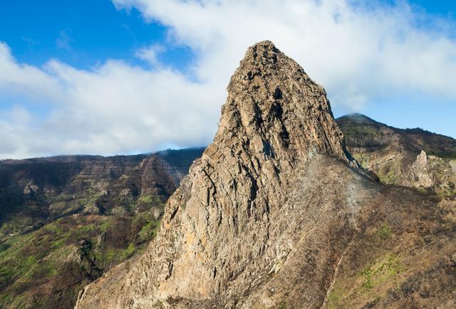
* Los Roques. Five or six volcanic plugs at the center of the island, e.g. Roque de Agando
- Benchijigua. The valley to the south of Los Roques. Amazing changes of vegetation as you drop into the valley.
- Valle Gran Rey - Stunning terraces in the upper valley. Lower valley still showing some influence (in places) of the time when this was a hippie hangout, but creature comforts widely available. In the upper part of the valley, there are several good paths up in the mountains.
Most visitors come for the top class walking. There are many paths all over the island, from gentle strolls through the rainforest to all day treks. Signage has improved dramatically over recent years, making self-guided walks much simpler.
Normal precautions regarding walking on your own apply on La Gomera, too. Always make sure that somebody knows where you are headed and when you can be expected to return. Pack rain and windproof warm clothing in your daypack even it's nice and sunny when you leave. Also, don't forget to take a cellphone and a torch with you, drinking water and something to eat. However, there are also many shorter walks (such as up one side of Valle Gran Rey and down the other) that need no more than sandals.
Walking in heavy rain might be dangerous (as well as unpleasant) due to rock falls and landslides.
Several firms offer guided walks, which can be useful if you don't have transport or want to do a point to point walk. One of these companies is Timah. They offer guided walks at around €30 each (including the transportation to the starting point of the walk as well as the trip back) with English and German speaking guides.
Another company offering walks is Viajes Temocoda. Temocoda's walks are a little bit more expensive but lunch is included in the price.
Visit the tourist office in Valle Gran Rey (Calle Lepanto, s/n. La Playa) or the various travel agencies in Valle Gran Rey for information about other providers of walks. Agencies can usually make the booking for you, but at least Timah has an office in Valle Gran Rey (La Puntilla) and you can book your walk there as well.
Guided walks can be recommended not only because they include transportation and free you from the infrequent bus service, but the guides will tell you all sorts of interesting tidbits about the island.
A good map will come handy. Recommended ones are by DWG, Kompass, and Freydag & Berndt. Each shows slightly different information, so consider buying two different ones. Maps and guidebooks are readily available in San Sebastian and Valle Gran Rey.
Electronic sources include:
- The OpenStreetMap Project, which many mobile Apps like OsmAnd, MAPS.ME, etc. use, provides fairly detailed/complete maps of the island, including hiking trails.
- wikiloc with hundreds of possible trails
Several books offer detailed descriptions of available routes such as The Landscapes of Southern Tenerife and La Gomera by Sunflower Books and Walk! La Gomera by DWG.
La Gomera is a good biking destination as it offers mountainous paved roads as well as single trails and dirt roads for the mountain bikers. In Valle Gran Rey there are three mountain bike tour operators and bike rentals available in the villages of La Playa, La Puntilla and Vueltas.
Be careful when riding down as the roads are steep and have tight bends. There are also two tunnels when coming down to Valle Gran Rey. The second and longer one can be circumvented by using the old road instead which goes by the mountainside. It starts on the right hand side of the tunnel entrance. However, extreme care is required as the railings on the old road are not in good condition (or missing altogether in places) and there are also big rocks and other debris on the road. When you drive in the tunnels make sure you have a headlight and a backlight (or at least a red reflector) so that cars can see you well ahead. Never ride without a well-fitting helmet.
The slow pace of life is contagious, the perfect antidote to stress. If you lack transport to Garojonay, walking in Valle Gran Rey (playa Del Ingles to bevond Vueltas) is easy and relaxing.
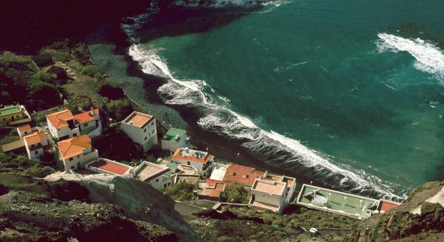 There are beaches at the end of most valleys, of varying quality. Valle Gran Rey has safe sandy beaches at Vueltas and El Charco (literally 'The Puddle'). Swimming can be challenging and even dangerous on the open beaches around the island. Playa la Caleta, near Hermigua, has a bar/restaurant on the beach. There is a semi-nude beach (clothing is optional) called Playa del Ingles behind La Playa in Valle Gran Rey. However, it's rocky and very dangerous for swimming especially when the sea is rough. There is a warning sign on the beach saying that the latest (fatal?) accident happened in the end of 2005, so keep this in mind if you think about taking a dip there.
San Sebastian has two good beaches, Playa Santiago (as the name suggests) also has a beach. There is a public pool at Playa de Vallehermoso (near El Castillo) and there is a swimming tank-thing by the remains of the embarcadero in Hermigua.
If you don't mind the long, steep, winding drive, there is a lovely little beach at Alojera.
Fascinating sub-tropical vegetation abounds with the unique Laurisilva rainforest in the national park, Garajonay, which is situated on the highest part of La Gomera. Laurisilva has a very special property in that it makes clouds into rain: Due to the pressing upwards of the trade winds, there are often clouds on the top of La Gomera; but the leaves of the trees of Laurisilva have pores that catch the small drops from the clouds. The surplus water absorbed is secreted so that the trees are raining, which increases precipitation from 50-100%. Of the remaining Laurisilva is 50% growing on La Gomera, which makes Garajonay unique from a nature conservation point of view. Laurisilva has in earlier periods covered large areas surrounding the Middle Sea, but disappeared due to climate changes. The National Visitor Centre at Juego de Bolas, above Las Rosas, has a selection of native and endemic plants, as well as various artesanal artifacts. There are plenty fine walking paths in Garajonay and the surrounding landscape.
There is also a botanic garden of sorts near Vallehermoso. This could be excellent if better maintained, but has the air of somewhere abandoned.
La Gomera is so beautiful that photo opportunities are everywhere. Most main roads have clearly signed viewpoints, including parking for a short stop.
There are a couple of diving schools on La Gomera, one in Valle Gran Rey and one in Playa Santiago.
Whale watching boat trips run from Valle Gran Rey with Excursiones Tina or Oceano Gomera.
Garajonay National Park. A [[UNESCO World Heritage site]] - extensive forested area on the top of the island. It protects the largest laurel rainforest remaining on Earth, "almost as old as the island itself" — the vegetation type has stayed the same for millions of years. The forest is made up of different evergreens flourishing under the mild temperatures. Trees are irrigated by the mist which sometimes covers the top of the island, especially in winter. The trees are covered in mosses and lichens. This environment extended all around the Mediterranean Sea in the Tertiary Era, so the National Park is considered a living relic. Several species endemic to the Canary Islands live here, including the Gomeran lizard, Gomeran skink, stripeless tree frog, laurel pigeon and Bolle's pigeon. Crisscrossed with footpaths of several difficulty levels, it is known as the green heart of La Gomera. Highlights include:
Benchijigua. The valley to the south of Los Roques. Amazing changes of vegetation as you drop into the valley.
Valle Gran Rey - Stunning terraces in the upper valley. Lower valley still showing some influence (in places) of the time when this was a hippie hangout, but creature comforts widely available. In the upper part of the valley, there are several good paths up in the mountains.
- Watercress soup with gofio (maize flour)
- Palm honey (Miel de Palma), palm tree syrup is boiled up to produce this delicious liquid that features in many Gomeran dishes, especially deserts.
- Mojo sauce comes in red or green - red is for meat and can be quite spicy, green for fish, based on garlic and coriander. Mojo in restaurants is usually home-made and quite variable, but always interesting. No burger chain uniformity here and all the better for it!
- Papas arrugadas (literally wrinkly potatoes). Exquisite if done well with small, black potatoes, but price rises often mean that now cheaper potatoes are used. Eat with red or green mojo. Restaurants:
- El Silbo, Carretera General 102, 38820 Hermigua, +34 922 88 03 04. Restaurant with typical Canarians meals. It provides Silbo Gomero whistling demonstrations. It also has a bar.
- La Vista, El Cedro, CV-22 (on the border of Garajonay National Park, off GM-1, +34 922 88 09 49, +34 922 88 08 04. 09:00–20:00. Quite and friendly mountain restaurant, surrounded by the Laurisilva forest. Has won prize of the best watercress soup of La Gomera.
El Silbo, Carretera General 102, 38820 Hermigua, +34 922 88 03 04. Restaurant with typical Canarians meals. It provides Silbo Gomero whistling demonstrations. It also has a bar.
La Vista, El Cedro, CV-22 (on the border of Garajonay National Park, off GM-1, +34 922 88 09 49, +34 922 88 08 04. 09:00–20:00. Quite and friendly mountain restaurant, surrounded by the Laurisilva forest. Has won prize of the best watercress soup of La Gomera.
Excellent freshly prepared fruit juices and milkshakes are widely available. If you are feeling brave, try parra, the local firewater (similar to Italian grappa) or a Gomeron, which is parra mixed with palm honey.
Local wine has recently been awarded DOC status. Try Garajonay white wine.
Great coffee, but remember that many locals take it with condensed milk (leche condensada). Try a 'leche y leche' - an expresso with a squirt of condensed milk and a splash of hot milk - much better than it sounds!