
Mojave National Preserve is a United States National Preserve that is part of the National Park System. It is in the southeastern desert of the California.
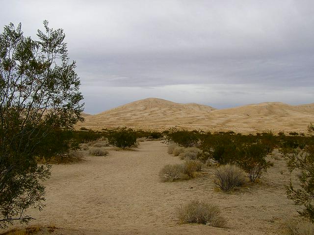
 Mojave National Preserve's vast expanse of desert lands include elements of three of the four major North American deserts: the Mojave, Great Basin, and Sonoran. The preserve's unique ecology is attributed to its remarkable geology. The desert is a land of old mountain ranges, sand dunes, great mesas and volcanic features such as cinder cones, domes, and lava flows; these features contribute to the remarkable beauty of the landscape. The most ancient rocks in the preserve, found in the Clark Mountains, are 2.5 billion years old.
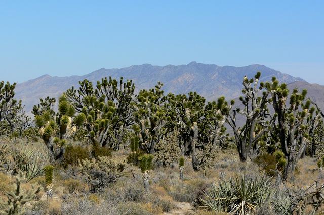
Changes in elevation and soil type, combined with dozens of seeps and springs, many in sheltered canyons, create a wide range of microhabitats that support a rich diversity of plants and animals. Some species are only found in this area. Notable plant assemblages include one of the largest and most dense Joshua Tree forests, cactus gardens, and reelect plant communities of white fir and chaparral.
Signs of animal life are subtle and easily overlooked. Birds and lizards are seen most frequently, but time of day, weather, and season all play a role in determining which animals are active. A large percentage of desert animals are nocturnal: being active at night rather than during daylight hours allows them to avoid high daytime temperatures and predators. Typical nocturnal animals include most desert rodents, bats, owls, mountain lion, skunks, and foxes. Other animals are crepuscular, active at dawn and dusk, and include coyotes, bighorn sheep and jackrabbits. Diurnal animals, those active during the day, are the most dynamic in that their activity periods will change based on temperature and season.
The weather is generally most comfortable in the spring and fall. Temperatures vary greatly by elevation. At low elevations, daytime highs are in the 70s (°F) in March; lows are in the 40s. Highs over typically begin in May and can last into October. In the mountains, daytime highs are in the 70s in May; lows are in the 50s. Winters can bring freezing temperatures and occasional snows, with daytime highs in the 50s and 60s.
Annual precipitation ranges from at lower elevations to nearly 10 inches in the mountains. Most rain falls between November and April; summer thunderstorms may bring sudden, heavy rainfall. The driest months are May and June. Winds are a prominent feature of Mojave Desert weather. Strong winds occur in fall, late winter, and early spring months.
There are no entrance fees to the preserve, but some of the preserve's campgrounds do charge a usage fee for overnight camping.
- Kelso Depot Visitor Center, +1 760 252-6108. 9AM-5PM daily. Opened in 1924 as a train station, Kelso Depot is an old two-story Union Pacific station built in the Spanish style. The depot narrowly escaped demolition in the 1980s before being taken over by the National Park Service, renovated, and reopened in 2005 as the visitor center for Mojave National Preserve. Former dormitory rooms contain exhibits describing the cultural and natural history of the surrounding desert. The baggage room, ticket office, and two dormitory rooms have been historically furnished to illustrate life in the depot in the first half of the 20th century. A 20-minute orientation film is shown in the theater. Downstairs. the Desert Light Gallery features rotating fine art collections by local artists, focusing on the cultural history and natural splendors of Mojave National Preserve.
- Hole-in-the-Wall Information Center, +1 760 252-6104. Winter (October-April): F-Su 9AM-4PM, Summer (May-September): Sa 10AM-4PM. This information center offers basic orientation, and a 12-minute film about the preserve. There is also a bookstore, restroom, water and telephone available.
- Mitchell Caverns, +1 760 928-2586. 8AM-5PM. Cave tours at the Mitchell Caverns in the Providence Mountains State Recreation Area (administratively not part of the preserve, but entirely surrounded by it).
- Ivanpah Lake. A dry lake bed used for land sailing located just outside of the preserve boundaries on BLM managed land.
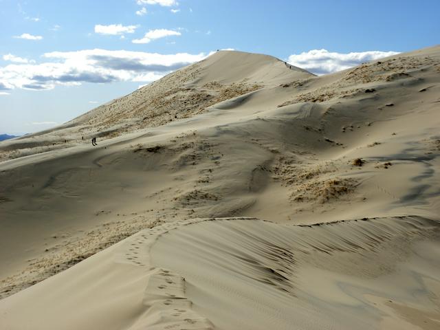
- Kelso Dunes. The massive Kelso Dunes are easily accessible by car (no four-wheel-drive needed). Second highest sand dunes in California, up to 700 feet. They are created from wind that carries dust and is reflected off a mountain. Beyond their large size, these dunes also have a phenomena called "singing" or "booming" dunes. When the moisture content is right in the sands, they emit a low thrumming sound as sand slides down the slope. Try running down the slope of a dune to trigger the sound. From the parking area, the dunes do not appear to be very far away or very large. This is an optical illusion. Allow at least an hour to climb to the top of the nearest dune.
- Cima Dome. A broad sloping upland dome, the erosional remnant of granite plutons that formed deep under the Earth's surface. Best viewed from Teutonia Peak Trail that leads through the densest concentration of Joshua Trees in the world.
Kelso Depot Visitor Center, +1 760 252-6108. 9AM-5PM daily. Opened in 1924 as a train station, Kelso Depot is an old two-story Union Pacific station built in the Spanish style. The depot narrowly escaped demolition in the 1980s before being taken over by the National Park Service, renovated, and reopened in 2005 as the visitor center for Mojave National Preserve. Former dormitory rooms contain exhibits describing the cultural and natural history of the surrounding desert. The baggage room, ticket office, and two dormitory rooms have been historically furnished to illustrate life in the depot in the first half of the 20th century. A 20-minute orientation film is shown in the theater. Downstairs. the Desert Light Gallery features rotating fine art collections by local artists, focusing on the cultural history and natural splendors of Mojave National Preserve.
Hole-in-the-Wall Information Center, +1 760 252-6104. Winter (October-April): F-Su 9AM-4PM, Summer (May-September): Sa 10AM-4PM. This information center offers basic orientation, and a 12-minute film about the preserve. There is also a bookstore, restroom, water and telephone available.
Mitchell Caverns, +1 760 928-2586. 8AM-5PM. Cave tours at the Mitchell Caverns in the Providence Mountains State Recreation Area (administratively not part of the preserve, but entirely surrounded by it).
Ivanpah Lake. A dry lake bed used for land sailing located just outside of the preserve boundaries on BLM managed land.
Kelso Dunes. The massive Kelso Dunes are easily accessible by car (no four-wheel-drive needed). Second highest sand dunes in California, up to 700 feet. They are created from wind that carries dust and is reflected off a mountain. Beyond their large size, these dunes also have a phenomena called "singing" or "booming" dunes. When the moisture content is right in the sands, they emit a low thrumming sound as sand slides down the slope. Try running down the slope of a dune to trigger the sound. From the parking area, the dunes do not appear to be very far away or very large. This is an optical illusion. Allow at least an hour to climb to the top of the nearest dune.
Cima Dome. A broad sloping upland dome, the erosional remnant of granite plutons that formed deep under the Earth's surface. Best viewed from Teutonia Peak Trail that leads through the densest concentration of Joshua Trees in the world.
- Four-wheel-driving - The multi-day drive along the historic Mojave Road is a favorite of serious four-wheel-drive enthusiasts (off-road riding not permitted however).
- Mountain biking - Seasoned mountain bikers will enjoy the challenges of some of the Preserve's backcountry roads. Bicycle Camping in and Around Mojave National Preserve provides a travelogue of a sample bicycle trip in the area.
Four-wheel-driving - The multi-day drive along the historic Mojave Road is a favorite of serious four-wheel-drive enthusiasts (off-road riding not permitted however).
Mountain biking - Seasoned mountain bikers will enjoy the challenges of some of the Preserve's backcountry roads. Bicycle Camping in and Around Mojave National Preserve provides a travelogue of a sample bicycle trip in the area.
The Kelso Depot Visitor Center and Hole-in-the-Wall Information Center have bookshops specializing in books related to desert topics.
- Nipton Trading Post, 107355 Nipton Rd (on the north edge of the Preserve. Sells books on desert-related topics, and some crafts from the region.
Nipton Trading Post, 107355 Nipton Rd (on the north edge of the Preserve. Sells books on desert-related topics, and some crafts from the region.
A lunch counter at the Kelso Depot opens daily from 9AM to 5PM (closed as of Mar 2014). There is no other restaurant in Mojave National Preserve. Restaurants are available in Baker, California. El Oasis Cafe at Nipton, on the northern edge of the preserve, provides home-cooked food six days a week.
Carry lots of water. There is very little water available in the Preserve. Bottled water can be purchased at the lunch counter in the Kelso Depot Visitor Center, along I-15 in Baker and at the gas station and store at I-15/Cima Road, at the general store in Nipton, at the Cima store (which isn't always open), and at the gas station in Fenner near the junction of I-40 and old Route 66 on the south side of the Preserve.
Public drinking water is available at the Mid Hills and Hole in the Wall campgrounds, at Mitchell Caverns campground (Providence Mountains State Recreation Area), and from water fountains at Kelso Depot visitor center washrooms (open 24 hours a day) or inside Kelso Depot during open hours.
In the backcountry, water is often available from the cistern at Marl Springs along the old Mojave Road (needs to be filtered or treated). Numerous small springs with varying (and sometimes non-existent) quantities of water exist throughout the Preserve for folks with water filters, such as Butcher Knife Spring. Research prior to travel relying on such springs is required. For example, a tiny stream of filterable water was available during one camper's visit at Indian Springs off Kelbaker Road a day after Xmas 2007.
- Baker - A tiny town on the park's northwestern border, Baker is the only significant town on I-15 in the remote desert stretch between Barstow and the Nevada border. It offers food, fuel and lodging, is home to the world's tallest thermometer, and is the starting point for those journeying north to Death Valley.
- Las Vegas - 60 miles from the park's eastern border, Sin City is America's playground.
[[Baker (California)|Baker]] - A tiny town on the park's northwestern border, Baker is the only significant town on I-15 in the remote desert stretch between [[Barstow]] and the [[Nevada]] border. It offers food, fuel and lodging, is home to the world's tallest thermometer, and is the starting point for those journeying north to [[Death Valley]].
[[Las Vegas]] - 60 miles from the park's eastern border, Sin City is America's playground.