
 Monument Valley is perhaps the most famous example of the classic American West landscape. In the Navajo Nation on the border of Arizona and Utah, the valley has been the backdrop for many movies and advertisements, ranging from Marlboro cigarette ads to the films of John Ford to Back to the Future 3 and Forrest Gump. In cinema and television, its landscapes are often used to represent the Old West of the cowboy era. The valley lies mostly in northern Arizona, but the northern part of the park is in Utah. The nearest town is Kayenta, about to the south.
The Navajo Nation and the State of Utah observe Mountain Daylight Saving Time from April through October, however Arizona does not observe Daylight Saving Time, so when you are in the State of Arizona and are not within the Navajo Nation, the time will be one hour earlier.
The distances are vast in the United States, and many people do not allow sufficient travel time, especially when they are used to the shorter distances in European and Asian countries. Many of Monument Valley's visitors are European and Japanese, and it is difficult for them to comprehend the distances you have to travel between destinations. If you travel from Las Vegas or Phoenix, your trip will take almost the entire day. You cannot see Monument Valley and also go further than the Grand Canyon to the south, and Moab to the north in the same day. Even staying at the Monument Valley for one night is cutting your stay extremely short relative to what there is to see in this part of the Navajo Nation.
Archaeological evidence indicates that the ancient Anasazi people inhabited the valley until AD 1300. Today over 100 sites and ruins have been found dating from these ancient people, including rock art. The Anasazi abandoned the area in the 1300s, leaving it empty of humans until the arrival of the Navajo.
In the 1860s, Merrick and Mitchell discovered silver in the region. They brought back the silver to a more civilized area, and got together investors to start a mining operation. The second mining operation started successfully. However, they disappeared - and the silver mine with them.
However, Monument Valley became so well-known in the mid-1900s, when many cowboy films and westerns were made here. As a result, Monument Valley has become a symbol of the Wild West, with its desertlike, harsh climate and dramatic buttes.
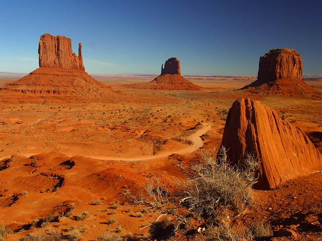
Monument Valley's landscape is what makes it so easily recognizable. The area is dominated by dry, sagebrush-covered valleys, but there are giant rocky outcrops that make the valley unique. On the sides of the valley are rocky cliffs, and canyons are lodged inside these cliffs. The buttes themselves are generally only a few hundred feet high (small compared to the size of the Grand Canyon), but the cliffs' extreme angle and sheerness make them as dramatic as the national parks in the Grand Circle.
But the flat plain surrounding the buttes is actually quite varied when viewed up close. Upon close-up view, gullies (small canyons), sand dunes, and of course the rocky outcrops make crossing the valley more interesting. However, the negative side to this is that hiking in Monument Valley is difficult even away from the buttes. The sand dunes are surprisingly high and can be hard to climb because the red soil is just as defiant as other types of soil.
The red soil found in Monument Valley is associated with that area and the elevation. Generally, elevations in the Colorado Pleateau between 5000 feet to 6000 feet tend to have red, sandy soil, while the regions to the west of Monument Valley (where elevation is more than above sea level) have a yellowish soil color. In other words, if Monument Valley's elevation was just a thousand feet higher, it would not be nearly as interesting a park to visit.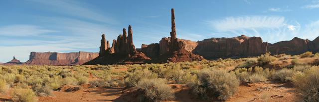
The Monument Valley area has wide a assortment of vegetation, including Juniper trees, yucca, Russian thistle (Tumbleweed), and Navajo Tea. Much of the vegetation is still used by the Navajos for medicinal purposes, and as dyes for their world-famous hand-woven rugs.
Landscapes in the Four Corners states often have Cryptobiotic soil, a biological soil crust composed of living cyanobacteria, green algae, brown algae, fungus, lichens, and/or mosses. Cryptobiotic soil crusts are important members of desert ecosystems and contribute to the well-being of other plants by stabilizing sand and dirt, promoting moisture retention, and fixing nitrogen for plants to use. Because of their thin, fibrous nature, cryptobiotic soils are extremely fragile systems. A single footprint or tire track is sufficient to disrupt the soil crust and damage the organisms. While some species within the soil crust system may regrow within a few years of a disturbance, the damage to slow-growing species may require more than a century before the delicate soil returns to its former productivity.
This sensitivity to disturbance means that travellers should be mindful of their impact on cryptobiotic soils. As a general rule, visitors should stay on pre-existing roads and trails, only traveling off-trail on durable surfaces such as bedrock or river gravel.
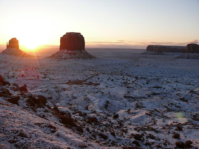 Temperatures range from the upper 80s to low 90s (°F) in the summer. Winter temperatures are usually above freezing in the daytime and below freezing at night, and sometimes drop below zero Fahrenheit during the nights. The last frost is expected about May 15 and the first frost is expected sometime in October. Summer nights are cool and comfortable, ranging from to . The summers are dry except during the monsoon season — beware of flash flooding during this time. Winters see some snow which can remain on the ground for several weeks, highlights the rock formations in new and spectacular ways.
Like most of the Colorado Plateau, temperatures in Monument Valley are not as hot as Death Valley because the elevation is much higher. Although temperatures can still get hot, they can also get bitterly cold in winter. The best times to the visit the park are March, April, May, or October. But if you want to see the snow, go to the park in December or January.
From California's Pacific Coast to the Rocky Mountains, a common climatic trend is discovered due to the "rain shadow" effect - the higher the elevation you reach, the higher the annual precipitation, while the lower elevation you reach, the drier.
Most of Monument Valley is part of Monument Valley Tribal Park, a Navajo tribal park, because Monument Valley is inside the Navajo nation. A tribal park is not the same as a United States National Park and Monument Valley Tribal Park charges a fee of $20 per car (4 persons included; each additional person $6 extra) for access to the loop road through the valley.
Because Monument Valley Tribal Park is a Navajo tribal park and not a national park, national park passes will not be accepted.
Except for a few trails, individuals wishing to hike in the valley or to visit sites not on the loop road must hire a Navajo guide for an additional fee.
Although there are very few self-guided trails to the major rocky outcrops found throughout the park, you can see these rocky outcrops (often called "mittens") from the U.S. Route 163. Along the sides of the valley are many red, rocky cliffs that can also be viewed from the main road.
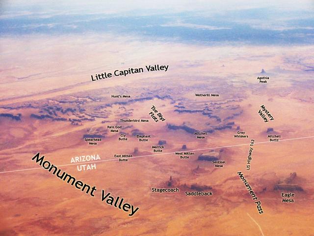
Although there are no specific names and regions for Monument Valley, it can be divided into several sections.
The Monument Valley Tribal Park headquarters. and the countryside to the east of it is the most easily accessible portion of Monument Valley Park. A hotel, restaurant, and visitor center are all in one main building next to some of the best Monument Valley overlooks, and from here, you can do a self-guided hike and view the Monument Valley landscape close-up. An unpaved road (open to the public) also leads from the park headquarters to the southeast, and goes into the Eastern Monument Valley.
At the northern end of the park headquarters is a campground and some small cabins.
Eastern Monument Valley. is the part of the Monument Valley with the most densely packed spires, buttes, and mesas. Many really unusual rock formations are found here, but they are not too hard to reach, since the 17-mile (25-km) loop road goes between these rock formations. If you want to quickly get the best of Monument Valley, go to this area.
There are also some good viewing points in Eastern Monument Valley. These are generally in the north part of Eastern Monument Valley, since Eastern Monument Valley is a higher elevation than the region north of John Ford Point - although it is still a lower altitude than the visitor center and park headquarters.
Although the loop drive and numerous rock formations are in Eastern Monument Valley, there are no hiking trails here. The southern end of Eastern Monument Valley is more remote than the northern end of it.
Although Western Monument Valley. is one of the harder parts of the Monument Valley to reach, its terrain is the most varied and interesting. It is really two separate regions: one has narrow canyons surrounded by tall rock formations, while the other has smaller, rounded rock formations called the "Toad Stools". This part of Monument Valley can only be reached with a tour guide; however, you can get as much information from this area as you can from the more popular parts of Monument Valley.
Although Western Monument Valley was not a filming location for the John Wayne films, it makes up for this lack of history with some abandoned Anasazi settlements. For some reason, the Anasazi people dwelt in the sides of cliffs and small caves, and they would put walls on the outer side of their caves. This gave them a small room inside, where they cooked their food.
Further west, west of Highway 163, the terrain becomes barren and there the color of the rocks turns to a whitish color. Some tour guides may go west of Highway 163, but for the most part, they do not. There used to be uranium mines west of Highway 163, and they have been closed down, but the area has still not been fully decontaminated.
Northern Monument Valley., is partially in Utah and Arizona and is the area to the north and directly east of the park headquarters. Tour guides do not generally go into this section of the valley and the best ways to experience it are to view it from the park headquarters, Wildcat Trail, or from U.S. Route 163.
The buttes and mesas are not as common in Northern Monument Valley as they are in Eastern Monument Valley, but this simply makes them more dramatic. The Northern Monument Valley buttes are probably the one most easily recognizable feature of the whole valley. The end of Northern Monument Valley closest to the park headquarters was shown in the film Stagecoach. The Wildcat Trail goes around North Monument Valley's "mittens", which look like hands; the mittens are in Northern Monument Valley, but are close to Eastern Monument Valley.
In the far north of Monument Valley, U.S. Route 163 goes between Eagle Mesa and Brigham's Tomb at a place called "Monument Pass". Apart from Train Rock a few miles away, these are the northernmost rock formations in Monument Valley and Monument Valley essentially ends here - to see more buttes, spires, and mesas, you can go a few hundred miles north to Arches National Park.
Although Goulding's lodge and apartments are not in the Monument Valley Tribal Park, they are part of Monument Valley for all practical purposes. This area of Monument Valley is the far northwest, a few miles from the main part of the Monument Valley Park and the buttes and spires. It is the only important part of Monument Valley west of Highway 163. The main road (the one that goes west from the visitor center) divides into two parts near Goulding's Lodge, and the southerly road choice goes between two mesas to a pass called "The Gap". Some short trails lead from the Goulding's campground and apartments to the northern mesa found at The Gap, and there is at least one arch here.
If you continue west from Goulding's, this main road is through The Gap is called "Rock Door Canyon Road", and it leads through the town of Monument Valley to Horse Pasture Canyon. Here, the canyon widens, the road goes from Utah to Arizona, stops being paved, and becomes Route 6410.
Although arches exist in Monument Valley, arches are more commonly found in Utah's famous Arches National Park.
- Big Hogan Arch. The name "Big Hogan" comes from the arch's appearance, which is similar to that of hogans. Hogans are a round type of building regularly seen in the Navajo Nation. "Big hogan" was in the past a gathering place for Indians, and was good for the traditional Navajo music because of the arch echoes.
- Ear of the Wind. A sand dune is right next to the arch.
- Goulding Arch. There is a large arch in one of the canyons near the Gouldings Lodge. Several trails lead to the area.
- Hidden Bridge Arch. This arch is part of a rock formation that is south of Big Hogan and Sun's Eye.
- Moccasin Arch. This arch is next to Big Hogan. Moccasin Arch is in a smaller cave than Big Hogan; however, its arch is more pronounced.
- Sun's Eye. This arch is unique because you can see the arch from a rock formation below it.
Big Hogan Arch. The name "Big Hogan" comes from the arch's appearance, which is similar to that of hogans. Hogans are a round type of building regularly seen in the [[Navajo Nation]]. "Big hogan" was in the past a gathering place for Indians, and was good for the traditional Navajo music because of the arch echoes.
Ear of the Wind. A sand dune is right next to the arch.
Goulding Arch. There is a large arch in one of the canyons near the Gouldings Lodge. Several trails lead to the area.
Hidden Bridge Arch. This arch is part of a rock formation that is south of Big Hogan and Sun's Eye.
Moccasin Arch. This arch is next to Big Hogan. Moccasin Arch is in a smaller cave than Big Hogan; however, its arch is more pronounced.
Sun's Eye. This arch is unique because you can see the arch from a rock formation below it.
The rocky outcrops generally include steep cliffs with a relatively flat area on top. These outcrops are actually divided into three categories: buttes, spires, and mesas. Mesas have the largest flat tops, while buttes have smaller tops, and spires have no flat top at all.
- Brigham's Tomb Butte. Butte near Monument Pass and U.S. Route 163 in the far north of Monument Valley. It is named after the famous Mormon leader, Brigham Young.
- Camel Butte. This is a small butte near John Ford's Point. Dirt roads go past three sides of the butte; one goes on its western side between the butte and John Ford Point, one goes on its southern side between the Camel Butte and another butte to the south, and the other eastern road goes east of Thumb Spire to the North Window Overlook.
- Eagle Mesa. This is the northernmost of the Monument Valley mesas. It is next to Sitting Hen and is near Brigham's Tomb, putting it within view of Monument Pass.
- Elephant Butte. This dramatic butte is northeast of John Ford's Point; if you go to John Ford's Point and look to your right, it should be the largest butte in that direction.
- Flying Eagle Butte. This butte is north of Sleeping Dragon Butte. The Flying Eagle is west of Yei Bi Chei and the eastern end of Flying Eagle is near a collection of sand dunes and Sand Springs. A canyon cuts into the southwestern part of the butte.
- Hunts Mesa. This mesa marks the southern end of Monument Valley. It is in Southern Monument Valley, the extremely remote part of the valley that even the local Navajo people avoid.
- Merrick Butte. This butte is named after a miner in the area who died while mining. He worked with Mitchell, who also got an outcrop named after him.
- Mitchell Mesa. This butte is named after a miner in the area who died while mining. He worked with Merrick, who also got an outcrop named after him.
Mitten, East. Probably the most recognizable feature in Monument Valley and Western films, along with the other Mitten. It is the larger of the two mittens, but is farther away from the park headquarters than the West Mitten.
- Mitten, West. Probably also the most recognizable feature in Monument Valley and Western films. You can get a fairly close-up view of this mitten from the Wildcat Trail, which goes in a loop around the West Mitten.
- Cly Butte. North Window overlook is between North Window Butte and Elephant Butte. In case you were wondering, there is no South Window overlook.
- Rock Door Mesa. This mesa is near the Goulding's Lodge and marks the edge of Monument Valley. If you go to the Goulding's Gas Station and look in the direction of the main lodging area, the large rock face you can see is the side of Rock Door Mesa. Two narrow valleys separate Rock Door Mesa from the other nearby mesas.
- Rooster Rock Spire. This spire is in the remote southeast of Monument Valley, meaning that even the all-day tours do not reach it.
- Sentinel Mesa. Mesa that can be seen from the Monument Valley Visitor Center; most of the mesa is in Utah, but a small southern section of it is in Arizona. Sentinel Mesa is particularly dramatic because it is such a large mesa in an area of Monument Valley where mesas are few and far between.
- Sleeping Dragon Butte. It looks like a dragon when viewed from the north and a ghost when viewed in the sky from the west. It is south of Flying Eagle and there are a few traditional Navajo hogans just south of the Sleeping Dragon. Parts of the Sleeping Dragon resemble the toadstools, but the cliffs around it and a large gash in the butte's southern side give its identity and location away.
- Spearhead Mesa. This large mesa looks like the letter "E" when viewed from the sky. It marks the northeastern boundary of the Eastern Monument Valley rock formations, and all of its three prongs are south of Artist's Point and north of The Cube and Yei Bi Chei Point.
- Stagecoach Spires. The Stagecoach Spires are a few miles north of where the Stagecoach film was made; they are in the far north of Monument Valley.
- The Hub. This butte is a two-step butte; there is a large butte with a narrow one on top of it.
- Three Sisters Spires. These three spires are best viewed from the John Ford Point area, where they can be most easily recognized. The smallest of the spires, which is in the center, has a rock that sits on it. The large spire on the southern end looks like a person when viewed from the John Ford Point area.
- Thumb Spire. This spire, next to Camel Butte, has several large rocks lying next to it.
- Totem Pole Spire. This lone spire is not far from the Yei Bi Chei Spires. If you look at the Yei Bi Chei Spires from the south, the Totem Pole is a lone spire that is a few hundred yards left of the other spires; looming behind the Totem Pole is Spearhead Mesa, while relatively flat terrain is behind Yei Bi Chei Spires.
- Yei Bi Chei Spires. These spires - which are next to Totem Pole Spire - are organized in a crescent-like shape. "Yei Bi Chei" is a Navajo term that refers to a particular special event that the locals used to do that involved dancing. The Yei Bi Chei spires can, particularly from the south, look like a group of dancers.
Brigham's Tomb Butte. Butte near Monument Pass and U.S. Route 163 in the far north of Monument Valley. It is named after the famous Mormon leader, Brigham Young.
Camel Butte. This is a small butte near John Ford's Point. Dirt roads go past three sides of the butte; one goes on its western side between the butte and John Ford Point, one goes on its southern side between the Camel Butte and another butte to the south, and the other eastern road goes east of Thumb Spire to the North Window Overlook.
Eagle Mesa. This is the northernmost of the Monument Valley mesas. It is next to Sitting Hen and is near Brigham's Tomb, putting it within view of Monument Pass.
Elephant Butte. This dramatic butte is northeast of John Ford's Point; if you go to John Ford's Point and look to your right, it should be the largest butte in that direction.
Flying Eagle Butte. This butte is north of Sleeping Dragon Butte. The Flying Eagle is west of Yei Bi Chei and the eastern end of Flying Eagle is near a collection of sand dunes and Sand Springs. A canyon cuts into the southwestern part of the butte.
Hunts Mesa. This mesa marks the southern end of Monument Valley. It is in Southern Monument Valley, the extremely remote part of the valley that even the local Navajo people avoid.
Merrick Butte. This butte is named after a miner in the area who died while mining. He worked with Mitchell, who also got an outcrop named after him.
Mitchell Mesa. This butte is named after a miner in the area who died while mining. He worked with Merrick, who also got an outcrop named after him.
Mitten, East. Probably the most recognizable feature in Monument Valley and Western films, along with the other Mitten. It is the larger of the two mittens, but is farther away from the park headquarters than the West Mitten.
Mitten, West. Probably also the most recognizable feature in Monument Valley and Western films. You can get a fairly close-up view of this mitten from the Wildcat Trail, which goes in a loop around the West Mitten.
Cly Butte. North Window overlook is between North Window Butte and Elephant Butte. In case you were wondering, there is no South Window overlook.
Rock Door Mesa. This mesa is near the Goulding's Lodge and marks the edge of Monument Valley. If you go to the Goulding's Gas Station and look in the direction of the main lodging area, the large rock face you can see is the side of Rock Door Mesa. Two narrow valleys separate Rock Door Mesa from the other nearby mesas.
Rooster Rock Spire. This spire is in the remote southeast of Monument Valley, meaning that even the all-day tours do not reach it.
Sentinel Mesa. Mesa that can be seen from the Monument Valley Visitor Center; most of the mesa is in Utah, but a small southern section of it is in Arizona. Sentinel Mesa is particularly dramatic because it is such a large mesa in an area of Monument Valley where mesas are few and far between.
Sleeping Dragon Butte. It looks like a dragon when viewed from the north and a ghost when viewed in the sky from the west. It is south of Flying Eagle and there are a few traditional Navajo hogans just south of the Sleeping Dragon. Parts of the Sleeping Dragon resemble the toadstools, but the cliffs around it and a large gash in the butte's southern side give its identity and location away.
Spearhead Mesa. This large mesa looks like the letter "E" when viewed from the sky. It marks the northeastern boundary of the Eastern Monument Valley rock formations, and all of its three prongs are south of Artist's Point and north of The Cube and Yei Bi Chei Point.
Stagecoach Spires. The Stagecoach Spires are a few miles north of where the Stagecoach film was made; they are in the far north of Monument Valley.
The Hub. This butte is a two-step butte; there is a large butte with a narrow one on top of it.
Three Sisters Spires. These three spires are best viewed from the John Ford Point area, where they can be most easily recognized. The smallest of the spires, which is in the center, has a rock that sits on it. The large spire on the southern end looks like a person when viewed from the John Ford Point area.
Thumb Spire. This spire, next to Camel Butte, has several large rocks lying next to it.
Totem Pole Spire. This lone spire is not far from the Yei Bi Chei Spires. If you look at the Yei Bi Chei Spires from the south, the Totem Pole is a lone spire that is a few hundred yards left of the other spires; looming behind the Totem Pole is Spearhead Mesa, while relatively flat terrain is behind Yei Bi Chei Spires.
Yei Bi Chei Spires. These spires - which are next to Totem Pole Spire - are organized in a crescent-like shape. "Yei Bi Chei" is a Navajo term that refers to a particular special event that the locals used to do that involved dancing. The Yei Bi Chei spires can, particularly from the south, look like a group of dancers.
Many rocks that are not mesas, buttes, or spires exist in Monument Valley. Some of these have fallen off of the other rock formations.
- Cube Rock. The Cube Rock is near the overlook point for Sand Springs in eastern Monument Valley. If you go to Yei Bei Chei point and look northeast, the small (in comparison with the other rocks), square-shaped rock is Cube Rock.
Cube Rock. The Cube Rock is near the overlook point for Sand Springs in eastern Monument Valley. If you go to Yei Bei Chei point and look northeast, the small (in comparison with the other rocks), square-shaped rock is Cube Rock.
These viewing points are places where you can view more of the landscape with ease. They share locations that are often in western films - for example, when the Indians have the White men surrounded, and the movie shows pictures of the Indians at locations like John Ford's Point.
- Artist's Point. From Artist's Point, you can look north toward the mittens and northern buttes.
- John Ford Point, John Ford Point Road (Eastern Monument Valley. This viewing point was featured in several Western films. You can get a picture of yourself at this point - standing on a horse, just like it was in the films. At John Ford Point, there are several buildings, making this one of the more developed parts of the park - it's a just a rough dirt road to get there. $5 for a picture of yourself "on the horse @ the point", as the posters say.
- John Wayne's Point. Named after the famous actor John Wayne, this point is near Lookout Point but instead faces east-southeast.
- Lookout Point, Main Monument Valley Road (Park Headquarters. From this viewing point, the mittens and northern buttes can be seen. The views from Lookout Point are the most well-known in Monument Valley.
- North Window Overlook. This overlook views the North Window and the desert expanse beyond it.
- Yei Bi Chei Point. This point overlooks the Sand Springs region of the park. The overlook point is near a riverbank. However, the area is also surrounded by rocks, so viewers will be looking up for rock formations at this overlook and not down. At Yei Bi Chei Point, the best views are not directly in front of you, where the country is more or less flat; for the best views, drive to the point and look behind you (west).
Artist's Point. From Artist's Point, you can look north toward the mittens and northern buttes.
John Ford Point, John Ford Point Road (Eastern Monument Valley. This viewing point was featured in several Western films. You can get a picture of yourself at this point - standing on a horse, just like it was in the films. At John Ford Point, there are several buildings, making this one of the more developed parts of the park - it's a just a rough dirt road to get there. $5 for a picture of yourself "on the horse @ the point", as the posters say.
John Wayne's Point. Named after the famous actor John Wayne, this point is near Lookout Point but instead faces east-southeast.
Lookout Point, Main Monument Valley Road (Park Headquarters. From this viewing point, the mittens and northern buttes can be seen. The views from Lookout Point are the most well-known in Monument Valley.
North Window Overlook. This overlook views the North Window and the desert expanse beyond it.
Yei Bi Chei Point. This point overlooks the Sand Springs region of the park. The overlook point is near a riverbank. However, the area is also surrounded by rocks, so viewers will be looking up for rock formations at this overlook and not down. At Yei Bi Chei Point, the best views are not directly in front of you, where the country is more or less flat; for the best views, drive to the point and look behind you (west).
Apart from the overlooks and rocky features, Monument Valley has many other varying sights.
- Anasazi Ruins, Toad Stools (Accessible by guided tour only; Western Monument Valley. Although there are many Anasazi ruins in Monument Valley, these ruins in the south of the park are probably the ones that are largest and most intact. They are, like Anasazi ruins in general, lodged built into a wide but shallow cave in the side of a rounded rock. Guided tours sometimes allow the tourists to climb the rock face and go inside the cave itself, where you can see how cooking done hundreds of years ago still leaves its mark on the cave ceiling. Tourists need to remember, though, that the Anasazi ruins are considered by the Navajo people to be sacred; and tourists also must not take any artifacts from the area surrounding the cave. (Because the Navajo people consider the ruins to be sacred, they do not allow historians to examine any artifacts from the Valley; this means that remnants of pottery can still be seen on the ground where they were left by the Anasazi hundreds of years ago.)
- Anasazi Ruin and Petroglyphs. This is another Anasazi Ruin of importance in Monument Valley, but this one is slightly different from the others because it is on the ground. The ruin is on the edge of a narrow canyon that has high rocks on both sides. However, these ruin is fenced off and the fence was moved farther out from the ruin in 2018 to better protect it and the petroglyphs. The petroglyphs, like many petroglyphs in the Colorado plateau, either depicted extinct animals or were the product of a vivid imagination. Hands in the petroglyphs are small and imply that the Anasazi people who lived at Monument Valley were unusually short.
- Sand Springs. There is a spring near a sand dune in this part of Monument Valley.
Anasazi Ruins, Toad Stools (Accessible by guided tour only; Western Monument Valley. Although there are many Anasazi ruins in Monument Valley, these ruins in the south of the park are probably the ones that are largest and most intact. They are, like Anasazi ruins in general, lodged built into a wide but shallow cave in the side of a rounded rock. Guided tours sometimes allow the tourists to climb the rock face and go inside the cave itself, where you can see how cooking done hundreds of years ago still leaves its mark on the cave ceiling. Tourists need to remember, though, that the Anasazi ruins are considered by the Navajo people to be sacred; and tourists also must not take any artifacts from the area surrounding the cave. (Because the Navajo people consider the ruins to be sacred, they do not allow historians to examine any artifacts from the Valley; this means that remnants of pottery can still be seen on the ground where they were left by the Anasazi hundreds of years ago.)
Anasazi Ruin and Petroglyphs. This is another Anasazi Ruin of importance in Monument Valley, but this one is slightly different from the others because it is on the ground. The ruin is on the edge of a narrow canyon that has high rocks on both sides. However, these ruin is fenced off and the fence was moved farther out from the ruin in 2018 to better protect it and the petroglyphs. The petroglyphs, like many petroglyphs in the Colorado plateau, either depicted extinct animals or were the product of a vivid imagination. Hands in the petroglyphs are small and imply that the Anasazi people who lived at Monument Valley were unusually short.
Sand Springs. There is a spring near a sand dune in this part of Monument Valley.
- Monument Valley Scenic Drive – While many incredible formations can be seen from the main roads, the best views can be had from the 17-mile loop road that runs through the valley. The road is open 6AM-8:30PM in the summer (May - Sep) and 8AM-4:30PM in the winter (Oct - Apr). This loop road in the southern section of the Monument Valley Tribal Park includes views of most of the mesas, buttes, and spires in Monument Valley. If a speed slightly under ten miles per hour is maintained along the whole drive, this loop will take about two hours; however, there are many stops and slow parts along the dirt road. However, the dirt road has many potholes and regions where cars can violently lurch and sway as they take the scenic drive. Other parts of the road are steep-sided and hard to climb in a car; therefore, it is best to take this road with a four-wheel drive, high clearance vehicle unless you want to damage your car.
- Wildcat Trail – This impressive trail takes you along the base of the West Mitten Butte, giving you a sense of how enormous the monuments are. This is the only self-guided walking tour in the park. Bring plenty of water, as the path is sometimes composed of deep sand which requires extra effort to navigate.
Monument Valley Scenic Drive – While many incredible formations can be seen from the main roads, the best views can be had from the 17-mile loop road that runs through the valley. The road is open 6AM-8:30PM in the summer (May - Sep) and 8AM-4:30PM in the winter (Oct - Apr). This loop road in the southern section of the Monument Valley Tribal Park includes views of most of the mesas, buttes, and spires in Monument Valley. If a speed slightly under ten miles per hour is maintained along the whole drive, this loop will take about two hours; however, there are many stops and slow parts along the dirt road. However, the dirt road has many potholes and regions where cars can violently lurch and sway as they take the scenic drive. Other parts of the road are steep-sided and hard to climb in a car; therefore, it is best to take this road with a four-wheel drive, high clearance vehicle unless you want to damage your car.
Wildcat Trail – This impressive trail takes you along the base of the West Mitten Butte, giving you a sense of how enormous the monuments are. This is the only self-guided walking tour in the park. Bring plenty of water, as the path is sometimes composed of deep sand which requires extra effort to navigate.
Horse rides are also available from various establishments both inside the park and in the general Monument Valley area. Rides may be only an hour, or overnight camping trips, and rates vary widely depending on the length of the ride from as little as about $30 per person for a half-hour ride, to hundreds of dollars. Horseback rides are available at John Ford's Point, a couple of miles into the valley on the loop road. Other Navajo guides will offer you horseback rides near the visitor center.
Navajo guides are required for travel off of the valley road. A number of companies provide guided tours of the Monument Valley that include transportation from the surrounding areas. Some companies will provide bus travel from nearby towns while others begin in Monument Valley Tribal Park. Some will provide just a brief tour with small stops, while others may take you on a hike and arrange all your meals. Most of these are done in windowless buses or trucks — be prepared to get covered in dust. You may wish to take a cue from the Japanese and bring a mask.
- Gouldings All-Day Tours. Gouldings does several tours of the valley, including an eight-hour "all-day" tour which goes to many remote regions of Monument Valley.
- Hydros Adventures Tours, +1 928 310-8141. Offers one-day and overnight hiking, rafting, backpacking, and adventure tours to Monument Valley, the Grand Canyon, Northern Arizona, and Southern Utah. Pickups in Phoenix, Las Vegas, and the Grand Canyon area.
- Majestic Monument Valley Touring Co., Monument Valley, Utah, +1 435 727-3432. Majestic Monument Valley Touring Co. is a certified tour company owned and operated by Navajo. They offer a variety of tours inside and outside of the Monument Valley Navajo Tribal Park. With their Navajo guides, customers learn about Navajo culture as they experience the beautiful landscape. They operate year-round.
- Monument Valley Safari, +1 928 209-1364. A Navajo-owned tour company that offers many different cultural tours of Monument Valley.
- Sandstone Tours, +1 435 200-5450. Sandstone Tours offers sunset and sunrise tours of Monument Valley and Mystery Valley as well as a variety of other affordable tours ranging from 1½ to 6 hours. Tour the valley with a local Navajo guide and enjoy several scenic stops along the way.
Gouldings All-Day Tours. Gouldings does several tours of the valley, including an eight-hour "all-day" tour which goes to many remote regions of Monument Valley.
Hydros Adventures Tours, +1 928 310-8141. Offers one-day and overnight hiking, rafting, backpacking, and adventure tours to Monument Valley, the Grand Canyon, Northern Arizona, and Southern Utah. Pickups in Phoenix, Las Vegas, and the Grand Canyon area.
Majestic Monument Valley Touring Co., Monument Valley, Utah, +1 435 727-3432. Majestic Monument Valley Touring Co. is a certified tour company owned and operated by Navajo. They offer a variety of tours inside and outside of the Monument Valley Navajo Tribal Park. With their Navajo guides, customers learn about Navajo culture as they experience the beautiful landscape. They operate year-round.
Monument Valley Safari, +1 928 209-1364. A Navajo-owned tour company that offers many different cultural tours of Monument Valley.
Sandstone Tours, +1 435 200-5450. Sandstone Tours offers sunset and sunrise tours of Monument Valley and Mystery Valley as well as a variety of other affordable tours ranging from 1½ to 6 hours. Tour the valley with a local Navajo guide and enjoy several scenic stops along the way.
There are a some gift shops and other stores in the Navajo Nation, including Monument Valley, where so many of the tourists go, and, of course, spend money. Goulding's in particular sells many items and services, including a grocery store, gift shop, gas station, and tours. There is also a gift shop at the visitor center in the Monument Valley Tribal Park. Tours for Goulding's are booked at the registration office.
More stores can be found in Kayenta, and, to some extent, Mexican Hat.
Some local individuals sell souvenirs, although the main local occupation is agriculture.
- All-Native Arts & Crafts. This gift shop is within walking distance of John Ford Point.
- Goulding's Gift Shop, Gouldings Trading Post Road. This is a gift shop in the Goulding's Lodge area. If you need to buy clothing items or books, this is a good store to visit. Fairly expensive.
- Goulding's Groceries, Rock Door Canyon Road, +1 435 359-0045. This is the main grocery store at Monument Valley. It is a reliable grocery store with food essentials, but, of course, no alcoholic drinks.
- Goulding's Store & Gas Station. There is a convenience store along with a gas station and basic car wash. At the car wash, you have to hose the car down yourself; it is not an automatic drive-through car wash.
- Navajo Market.
- Visitor Center Monument Valley, Main Monument Valley Road. The visitor center has a large gift shop with a wide variety of souvenirs. They also showcase an impressive amount of hand-crafted Native American arts and crafts.
All-Native Arts & Crafts. This gift shop is within walking distance of John Ford Point.
Goulding's Gift Shop, Gouldings Trading Post Road. This is a gift shop in the Goulding's Lodge area. If you need to buy clothing items or books, this is a good store to visit. Fairly expensive.
Goulding's Groceries, Rock Door Canyon Road, +1 435 359-0045. This is the main grocery store at Monument Valley. It is a reliable grocery store with food essentials, but, of course, no alcoholic drinks.
Goulding's Store & Gas Station. There is a convenience store along with a gas station and basic car wash. At the car wash, you have to hose the car down yourself; it is not an automatic drive-through car wash.
Navajo Market.
Visitor Center Monument Valley, Main Monument Valley Road. The visitor center has a large gift shop with a wide variety of souvenirs. They also showcase an impressive amount of hand-crafted Native American arts and crafts.
There are a couple restaurants in Monument Valley - these should be enough to have a varied dining experience for a couple nights. For more restaurants, go to Kayenta or Mexican Hat.
- Goulding's Dining Room, +1 435 727-3231. The dining room is at the top of the main Goulding's Lodge area and serves standard American cuisine.
- Linda's Frybread Stand, +1 602 299-0173. Right near John Ford's Point, this frybread stand is near the Indian Arts & Crafts gift shop.
- The View Restaurant. This is a large restaurant. It serves some southwestern food and Indian food, which in the Navajo Nation is fairly similar to Mexican food. The restaurant is right next to John Wayne's Point and therefore has excellent views. The restaurant is open for breakfast, lunch, and dinner.
Of course, the two Goulding's stores sell food. The park's visitor center sells snacks, and there may be stands around the park offering Navajo fry-bread and other items.
The Goulding's All-Day Tour goes to a remote spot in Monument Valley where the tour guide barbecues hamburgers.
Goulding's Dining Room, +1 435 727-3231. The dining room is at the top of the main Goulding's Lodge area and serves standard American cuisine.
Linda's Frybread Stand, +1 602 299-0173. Right near John Ford's Point, this frybread stand is near the Indian Arts & Crafts gift shop.
The View Restaurant. This is a large restaurant. It serves some southwestern food and Indian food, which in the Navajo Nation is fairly similar to Mexican food. The restaurant is right next to John Wayne's Point and therefore has excellent views. The restaurant is open for breakfast, lunch, and dinner.
Drinking water and other beverages are available at the visitor center and at Goulding's grocery and campground.
Alcoholic beverages are prohibited within the Navajo reservation. The nearest alcoholic beverages are sold at the gas station in Mexican Hat, about from the park, but if you want much besides beer you should get it in Moab or Flagstaff. There is also a bar at the San Juan Inn in Mexican Hat, and other restaurants in Mexican Hat sell alcohol.
Regulations within the valley include the following:
- Fires are allowed only in grills, firepits, and other designated areas.
- Visitors must stay on the valley road or one of the self-guided trails unless accompanied by a Navajo guide.
- Rock climbing is prohibited.
- Personal photography is allowed, but when photographing Navajo residents and their property permission is required and a gratuity is expected. Commercial photography requires a permit.
- Dogs must be leashed at all times.
- Alcoholic beverages are prohibited on Navajo lands.
- Do not disturb plants or animals.
Dangers in the valley are minimal, but visitors should not reach under rocks, ledges or bushes due to dangers from rattlesnakes (in summer), scorpions and spiders.
There are also weather-related dangers. Like much of the Southwestern United States, Monument Valley can have sudden rainstorms that cause the once-dry creeks to fill and pull any debris with the water as it travels downstream. Therefore, do not hike in Monument Valley unless you know that the weather will be good for hiking.
There used to be a Uranium Mine. near Monument Valley. It was closed down, but the region is still radioactive.
There used to be a Uranium Mine. near Monument Valley. It was closed down, but the region is still radioactive.
Only a couple days can be spent in Monument Valley because there are only a few self-guided trails and tours in the park.
Monument Valley is part of the Grand Circle, which beside Monument Valley includes (but is not limited to) the following national parks:
- Arches National Park — this park is known for its thousands of arches, of course, which are seen in countless pictures and documentaries around America.
- Bryce Canyon National Park — Bryce is known for its city rock formations, which are inside a forested region of southwestern Utah.
- Canyonlands National Park — this park is known for its "Island in the Sky" between the Colorado River and the Green River.
- Capitol Reef National Park
- Grand Canyon National Park — this park is one of the most commonly visited parks in America and running through the park is a 5,000-foot-deep canyon through which the Colorado River flows.
- Great Basin National Park — in this park is the great Wheeler Peak, which is more than 13,000 feet high and is one of Nevada's highest mountain peaks. This park is also home to juniper and pine forests that are on the eastern side of a Sierra Nevada-like mountain range.
- Hovenweep National Monument
- Mesa Verde National Park
- Natural Bridges National Monument
- Zion National Park — despite being near several other beautiful national parks and attractions, Zion National Park is so well-known since it lies on the border between the forested mountain ranges to its north and the dry desert to the south.
The following lists national monuments and Navajo tribal parks that are within the Navajo Nation.
- Canyon de Chelly National Monument
- Four Corners Navajo Tribal Park — 92 miles to the east, Four Corners is the only point in the United States where four states meet. A monument and visitor center commemorates the spot.
- Natural Bridges National Monument — 60 miles to the north, this monument is home to several impressive rock formations that span a river canyon, forming natural rock bridges.
[[Four Corners|Four Corners Navajo Tribal Park]] — 92 miles to the east, Four Corners is the only point in the United States where four states meet. A monument and visitor center commemorates the spot.
[[Natural Bridges National Monument]] — 60 miles to the north, this monument is home to several impressive rock formations that span a river canyon, forming natural rock bridges.
- Kayenta — 20 miles south, this town offers the nearest lodging and supplies.
- Mexican Hat — 22 miles north on Hwy 163, where the river cuts through Monument Valley to the south & Valley of the Gods to the north.
- Page — This town is about 120 miles to the west and provides access to Lake Powell.
[[Kayenta]] — 20 miles south, this town offers the nearest lodging and supplies.
[[Mexican Hat]] — 22 miles north on Hwy 163, where the river cuts through Monument Valley to the south & Valley of the Gods to the north.
[[Page]] — This town is about 120 miles to the west and provides access to [[Glen Canyon National Recreation Area|Lake Powell]].