
Sajama National Park is in Oruro departement of Bolivia.
 Sajama is a picturesque national park that offers impressive landscapes like around San Pedro de Atacama, the Altiplano Potosí region and the other natural sights around Uyuni. In addition, Sajama puts a focus on hiking and mountain climbing, whereas the other sites emphasis more on mass tourism using 4WDs.
If you ever just wanted to hike straight into the plains along the Salar de Uyuni tour, this is the place to do so. The Sajama National Park can be described as the perfect combination of hiking and meditation. Hiking through the plains of the Sajama National Park one is often surprised how quiet nature can be with often barely a sound for kilometres, except for maybe you footsteps. But it also offers properly guided climbs of the impressive surrounding volcanoes and mountains.
Sajama does not experience masses of tourists like in other areas of Bolivia and is still hidden with exceptional flora and fauna, vast hiking opportunities, high altitude trekking, and of course mountain climbing. meditation,
The park was already founded in 1939.
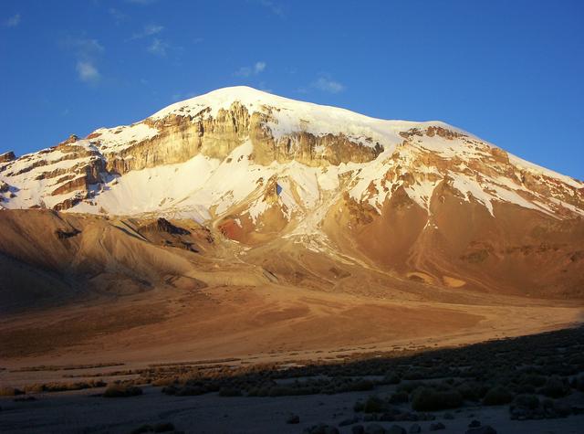
The landscape is similar to the Lagunas and Altiplanos at the Chilean and Bolivian border near San Pedro de Atacama. Also, the highest peak of Bolivia can be found here, Nevado Sajama throning over the park. Generally, the altitude in the park ranges from 4,200-6,500 m, with the Sajama village at 4,240 m and regular non-guided trails up to 5,000 and 5,600 m.
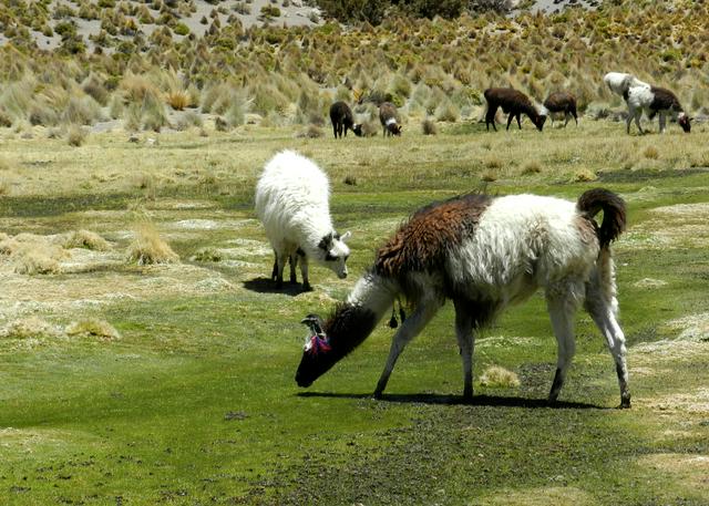
The most popular animals of the park include viscachas, lamas, vicuñas, alpacas, horned coots. But you can also find armadillos, bears, Andean cats, pumas, condors, pink flamingos, hummingbirds, rheas, and others here.
Except for November to March, temperatures during the night are generally below 0°C. During the day with the sun temperatures reach between 15°C-30°C, latter especially in summer. Nevertheless, many people choose to come here in July and August, which is high season in the park.
The national park ticket office. is about 1 km from the Sajama Junction. It opens at 08:00. Bs. 100.
The national park ticket office. is about 1 km from the Sajama Junction. It opens at 08:00. Bs. 100.
- Horned coots (animal), Laguna Sora Pata (Getting there only by hiking the Tres Lagunas Trail.. Laguna Sora Pata offers this rare and protected species of ducks with their surprisingly large nests on the lagoon. Quite picturesque with the snow covered large mountain in the back. If you follow the trek further northeast, shortly after the end of the lagoon you can regularly see large amounts of viscachas.
- Laguna Huayna Khota. A great place to see birds like the Andean avocet, the Andean lapwing, the horned coot, the ruddy duck, the cattle egret, the Puna teal, or the yellow-billed pintail.
- Laguna Isla. Nice and calm waters with lamas feeding in front of the picturesque mountain ranges. Great for some shots with the camera.
Horned coots (animal), Laguna Sora Pata (Getting there only by hiking the Tres Lagunas Trail.. Laguna Sora Pata offers this rare and protected species of ducks with their surprisingly large nests on the lagoon. Quite picturesque with the snow covered large mountain in the back. If you follow the trek further northeast, shortly after the end of the lagoon you can regularly see large amounts of viscachas.
Laguna Huayna Khota. A great place to see birds like the Andean avocet, the Andean lapwing, the horned coot, the ruddy duck, the cattle egret, the Puna teal, or the yellow-billed pintail.
Laguna Isla. Nice and calm waters with lamas feeding in front of the picturesque mountain ranges. Great for some shots with the camera.
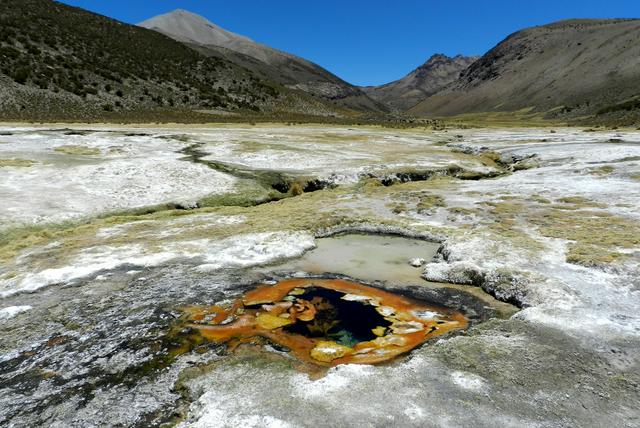
- Geyser and hot spring field. Surprisingly versatile with hot pools, geysers and mud pools. It also has some little and free and natural pools you can soak in—just select a place in the river that has reasonably much space and is hot enough. But also, check out you map app to find them. The very first pool is already great for a dip. (Control the heat of pool with rock near small waterfall, which blocks the water to the geyser. You can help making the pool bigger & deeper, namely where the water is calm and the hot geysers are. Maybe even bring a shovel, but do not tell the locals about this secret place, or it will be gone soon. Allow for enough cool water to flow by outside of the pool. And watch out, the soil can be very hot.)
- Private hot spring(s). Quite expensive, considering the hot spring along the Salar de Uyuni tour is just Bs. 6. There are other (private) hot springs nearby, try this hot spring. or this one.. From the latter a trail north leads to two more hot springs, which be might be for free. Bs. 30.
- Termales Donia Theodora. A little cheaper and free if the lady is not there. So, go early or late (coming from the Tres Lagunas Trail), or just be lucky (e.g. in off-season). Bs. 10 or free.
 The following mountains and treks can be done without a guide and if you are reasonably fit.
- Hike the plains. The plains and rolling hills of the Sajama National Park are great if you just wanted to hike and relax or meditate without an actual destination. Just pick a direction and hike for hours, exploring the amazing surroundings or any hill that looks like it would provide a proper view. This can also be a great way of getting into and out of Sajama from the highway.
- Mt. Quewiña (4,550 m). This is the little hill right east of Sajama village. You can see the trail clearly, which goes straight up the hill. But only do it if you are not going to do Mt. Huisalla right next to it north, which has much better views.
- Mt. Huisalla (5,053 m). This medium-difficult peak provides amazing views of Nevado Sajama, Sajama village and the surrounding plains. Due to the high altitude it can be a day trek, the higher you get, the harder it will become to progress. Take your time! There is a trail that goes almost straight up from the village, or you choose the longer one that circles the mountain to the east and then offers a less exhausting final trek at the end.
- Tres Lagunas Trail (41 km). The trail takes 8-12 hr, but add 1-2 hr for the geysers, hot pools and local fauna. Highlights are the many animals along the way, especially near and around the three lagoons: Casiri Macho, Sora Pata and Chiar Kkota. Many people do it in 1 day, but 2 days is possible if you have a proper tent and warm sleeping bag. There are marked camp sites along the trail, but generally many opportunities exist. The trail can easily be done without guide, but it is better go in a group if you are not a regular hiker. The trail actually enters Chilean territory, but only for about 3-5 km, after which you will return to Bolivia. If you stay on the trail and do not enter further into Chile, this is not an issue. The trail is well visible most of the time, but you should bring GPS and a proper map to take the right turns and trails.
* Cerro Chiar Kkota (5,452 m). In case you are taking your time with the Tres Lagunas Trail and camp overnight, you might in addition consider this interesting and exciting side-tour with magnificent views of the Lagunas, into the Sajama valley as well as Nevado Sajama itself. Allow for an extra day and night to conquer this mountain, but camping near the Laguna Chiar Kkota is very picturesque and convenient at the same time. In winter, the trail can be impassible.
- Base Camp Trail (5,680 m). If you want to hit the height but without a guide, try hiking up to the base camp of Nevado Sajama. In winter, the trail might be impassable with regular boots due to snow and ice, but in summer it is definitely possible. Again, take you time and start the descend early enough—it gets dark at 18:00.
For the following treks you will need a guide and proper equipment. Sometimes, transport via 4WD is necessary.
- Mt. Parinacota (6,348 m). A day hike with guide that starts at 01:30 at night, so you reach the top right before sunset. Transport via 4WD is necessary and provided with a tour. There is actually trails from both the Chilean and Bolivian side, so you might meet some people heading up from the Chilean side to the top of this peak separated by the border. Bs. 1,600 per group.
- Mt. Pomerape (6,282 m). Even though lower, this one is more difficult than Parinacota.
- Nevado Sajama (6,542 m). A volcano whose peak is the highest point in Bolivia and guided 2-3 day mountain climb with overnighting at the Campo Alto at 5,680 m.
Hike the plains. The plains and rolling hills of the Sajama National Park are great if you just wanted to hike and relax or meditate without an actual destination. Just pick a direction and hike for hours, exploring the amazing surroundings or any hill that looks like it would provide a proper view. This can also be a great way of getting into and out of Sajama from the highway.
Mt. Quewiña (4,550 m). This is the little hill right east of Sajama village. You can see the trail clearly, which goes straight up the hill. But only do it if you are not going to do Mt. Huisalla right next to it north, which has much better views.
Mt. Huisalla (5,053 m). This medium-difficult peak provides amazing views of Nevado Sajama, Sajama village and the surrounding plains. Due to the high altitude it can be a day trek, the higher you get, the harder it will become to progress. Take your time! There is a trail that goes almost straight up from the village, or you choose the longer one that circles the mountain to the east and then offers a less exhausting final trek at the end.
Tres Lagunas Trail (41 km). The trail takes 8-12 hr, but add 1-2 hr for the geysers, hot pools and local fauna. Highlights are the many animals along the way, especially near and around the three lagoons: Casiri Macho, Sora Pata and Chiar Kkota. Many people do it in 1 day, but 2 days is possible if you have a proper tent and warm sleeping bag. There are marked camp sites along the trail, but generally many opportunities exist. The trail can easily be done without guide, but it is better go in a group if you are not a regular hiker. The trail actually enters Chilean territory, but only for about 3-5 km, after which you will return to Bolivia. If you stay on the trail and do not enter further into Chile, this is not an issue. The trail is well visible most of the time, but you should bring [[#Get around|GPS and a proper map]] to take the right turns and trails.
* Cerro Chiar Kkota (5,452 m). In case you are taking your time with the Tres Lagunas Trail and camp overnight, you might in addition consider this interesting and exciting side-tour with magnificent views of the Lagunas, into the Sajama valley as well as Nevado Sajama itself. Allow for an extra day and night to conquer this mountain, but camping near the Laguna Chiar Kkota is very picturesque and convenient at the same time. In winter, the trail can be impassible.
Base Camp Trail (5,680 m). If you want to hit the height but without a guide, try hiking up to the base camp of Nevado Sajama. In winter, the trail might be impassable with regular boots due to snow and ice, but in summer it is definitely possible. Again, take you time and start the descend early enough—it gets dark at 18:00.
Mt. Parinacota (6,348 m). A day hike with guide that starts at 01:30 at night, so you reach the top right before sunset. Transport via 4WD is necessary and provided with a tour. There is actually trails from both the Chilean and Bolivian side, so you might meet some people heading up from the Chilean side to the top of this peak separated by the border. Bs. 1,600 per group.
Mt. Pomerape (6,282 m). Even though lower, this one is more difficult than Parinacota.
Nevado Sajama (6,542 m). A volcano whose peak is the highest point in Bolivia and guided 2-3 day mountain climb with overnighting at the Campo Alto at 5,680 m.
Geyser and hot spring field. Surprisingly versatile with hot pools, geysers and mud pools. It also has some little and free and natural pools you can soak in—just select a place in the river that has reasonably much space and is hot enough. But also, check out you map app to find them. The very first pool is already great for a dip. (Control the heat of pool with rock near small waterfall, which blocks the water to the geyser. You can help making the pool bigger & deeper, namely where the water is calm and the hot geysers are. Maybe even bring a shovel, but do not tell the locals about this secret place, or it will be gone soon. Allow for enough cool water to flow by outside of the pool. And watch out, the soil can be very hot.)
Private hot spring(s). Quite expensive, considering the hot spring along the [[Salar de Uyuni]] tour is just Bs. 6. There are other (private) hot springs nearby, try this hot spring. or this one.. From the latter a trail north leads to two more hot springs, which be might be for free. Bs. 30.
Termales Donia Theodora. A little cheaper and free if the lady is not there. So, go early or late (coming from the Tres Lagunas Trail), or just be lucky (e.g. in off-season). Bs. 10 or free.
- There are a few little stores in town where you can basic supplies and food for cooking. But do not expect a large supply of fruits and vegetables like in the cities. You are often better off relying on the cooking skills of the local "restaurants".
- In addition, you can find local handicraft and artesanal clothes.
There are a few little stores in town where you can basic supplies and food for cooking. But do not expect a large supply of fruits and vegetables like in the cities. You are often better off relying on the cooking skills of the local "restaurants".
In addition, you can find local handicraft and artesanal clothes.
Most accommodations in town also provide proper lunch and dinner, even though usually the regular Bolivian dishes. Walk around to find the ones open or still with your place.
Always take your rubbish and even that of other people along the trail—just the trail, roads are useless because they are frequented by non-caring Bolivians. Hiking in the park is free and possible without a guide (unlike Torotoro National Park). But if the park is going to be messed up, it will probably soon be converted to a guide-only version. So, let's keep that gem clean.