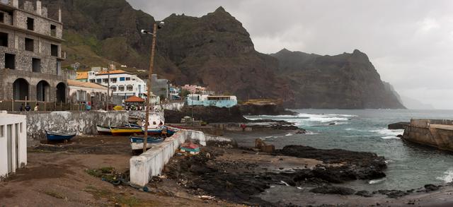
Santo Antão is the second biggest of the Cape Verde islands.
Santo Antao is a surprising island. When you land at the ferry port it appears to be dusty and sandy like many of the other islands but in half an hour you can be driving up steep, windy roads and suddenly find yourself in pine forest and skimming the edge of a volcano! Much of the island is unexplored, but the best part to head for is the north east corner where there is great hiking. In Ponto do Sol you can scuba dive, hike or rock climb in a very picturesque setting. Accommodation is inexpensive and would suit all budgets. Santo Antao is the most northern and the most western island of the archipelago, with the area of 779 km², maximum length of 43 km and maximum width of 24 km. The highest point is Topo de Coroa, 1,979 m high.
Visiting Santo Antão can offer many different experiences, moods, views, types of landscapes and different climates; even the dialects the people speak and the way they live vary somewhat---almost like “island hopping”, except that you can spare yourselves the time, costs, and stress, not to mention CO² emissions, of extra inland flights. An alternative (or complement) to the “north east corner” of Santo Antão, is Tarrafal de Monte Trigo in the the southwestern part of the island. Although the number of hikes may not be as large as in the northeast, there is still great hiking, usually starting right in front of your door---for example along the coast to the next village, Monte Trigo (and back by fishing boat); or to the waterfall; and others....it is a good starting point to reach the highest mountain, the Tope de Coroa, taking the morning aluguer for a short stretch and then hiking.
But there is much more to do than hiking---if you are interested in swimming, this is the right place to come to. Tarrafal has the largest, most pristine, and only really swimmable beach on the island. Whereas in other parts of the island it may be possible to swim on a few days of the year, in Tarrafal it is only impossible to swim on a few days of the year, the rest of the time it is possible. The reason for this is that Tarrafal is sheltered from the northeast trades winds that blow most of the time, making other parts on the island very windy and their beaches subject to rough waves which make swimming dangerous or impossible. Snorkeling, scuba diving, boat rides and fishing are also possible. Tarrafal has more sunny days than many parts of the island. It is therefore not quite as green as some parts where rain and clouds are more frequent, although being a true oasis and receiving water all year round from springs, it is still quite green in the valley. This “microclimate” sets it apart from the rest of the island---it means, for example, that it is also a great place to relax, just “hang out”, and you can dine outside comfortably virtually every evening with no need for windbreakers and jackets. Many travelers choose to visit both “sides” of the island---aside from Ponta do Sol there are destinations like Valley of Paúl, Chã de Igreja and others. If you choose to do this, plan some days (or more!) in each part, as going back and forth in one day is too far and takes too much time.
- Farol de Boi, Pontinha de Janela. The biggest and the oldest lighthouse of Cape Verde. Built 1886, now abandoned.
- Statue of Santo Antonio, Vila das Pombas.
- Cova. A valley in a crater of an extinct volcano
Farol de Boi, Pontinha de Janela. The biggest and the oldest lighthouse of Cape Verde. Built 1886, now abandoned.
Statue of Santo Antonio, Vila das Pombas.
Cova. A valley in a crater of an extinct volcano
 Hiking, swimming, snorkeling, diving, fishing, trekking
Santo Antão Scuba Diving in Tarrafal de Monte Trigo
The best beach is in Tarrafal de Monte Trigo
