
 Teide National Park (Spanish: Parque Nacional del Teide) is the most visited national park in Europe with over 4 million visitors in 2016. With an area of 190 km² it occupies the highest 10% of Tenerifes land area, one of the Canary Islands which administratively belong to Spain. It was declared a in 2007 and has since been one of the 12 Treasures of Spain.
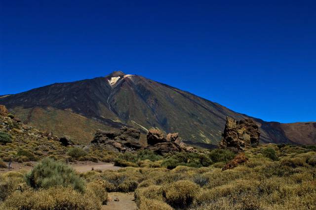
The park is known for its 2 volcanoes, El Teide. (3,718 m) and Pico Viejo. (3,135 m), the only peaks on the Canary Islands above 3,000 m above sea level.
The park is known for its 2 volcanoes, El Teide. (3,718 m) and Pico Viejo. (3,135 m), the only peaks on the Canary Islands above 3,000 m above sea level.
The park is known for its 2 volcanoes, El Teide. (3,718 m) and Pico Viejo. (3,135 m), the only peaks on the Canary Islands above 3,000 m above sea level.
Teide National Park is the largest and oldest national park on the Canary Islands and the third oldest in Spain, declared a national park in 1954. It is located in the municipality La Orotava, and famous for its active volcanoes El Teide and Pico Viejo.
Mount Teide is the highest mountain of Spain if measured from sea level, the highest volcano in the Atlantic Ocean, and the 3rd highest volcano in the world measured from the ocean floor with a total elevation of 7,500 m. Mount Teide is the most famous natural icon of the Canary Islands, and a popular sight on postcards. Its crater has a diameter of over 16 km with jagged edges called the Cañadas at altitudes between 2,000 - 2,500 m. The volcanic massif of Mount Teide and Pico Viejo rises above the crater.
Mount Teide is a Decade Volcano, identified as one of the 16 most dangerous volcanoes in the world due to its history of explosive eruptions and proximity to populated areas. This makes Mount Teide one of the best studied stratovolcanoes, although most of the research takes place in summer as its summit is covered by snow in winter.
The area of the national park has been of significant historical value, dating back to the Guanche era as evidenced by archaeological remains in the mark. For the Guanches it was a place of worship, much like Mount Olympus for the ancient Greeks, who considered it an entry to hell. After its designation as national park in 1954 it was awarded the European Diploma of Protected Areas in 1989, an award which has been renewed every 5 years since in recognition of the conservation efforts taking place.
The landscape of the park is mountainous, and the peak of the volcano is visible from most parts of the park. Elevation increases inland, and the flanks of El Teide itself are rather steep. At lower altitudes, the slopes of the park are covered in Canarian pine trees, giving the temperate zone a characteristic look. At higher altitudes and inside the crater, the landscape is rocky and barren, with only low shrubs and grasses preventing high winds from carrying dust in the air.
 The lava flows on the flanks of Mount Teide erode into a nutrient and mineral rich soil that supports very diverse flora, including 168 vascular flora species of which 33 are endemic to Tenerife. The Canary Island pine tree (Pinus canariensis) covers slopes between 1000 — 2100 m in dense pine forests, with a timberline ca. 1000 m lower than that of continental mountains of comparable latitude. Beyond 2,000 m vegetation becomes more scarce, although the Canãdas (caldera ridge) provides enough protection against wind to allow the Canary Island juniper tree to grow where otherwise only shrubs would flourish.
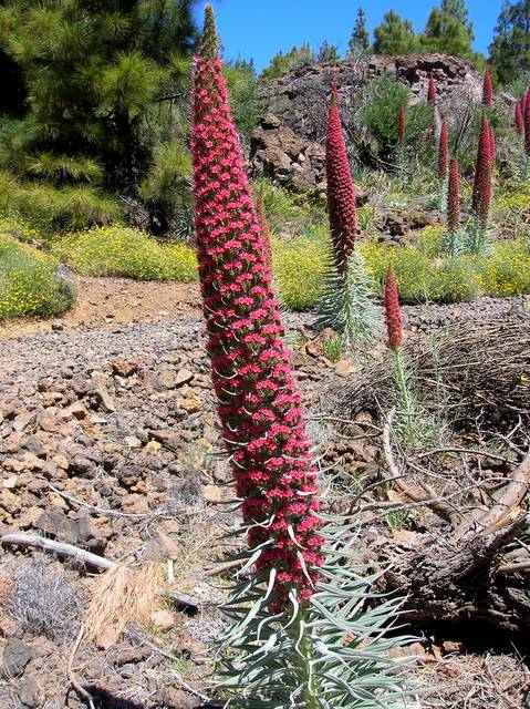
The white broom (Spartocytisus supranubius) is the dominant flower in the park, recognizable by its white and pink flower petals, but often confused with the Canary Island wallflower which has white and violet petals. The Teide daisy can be found at altitudes close to 3,600 m, whereas the Teide bugloss (Echium wildpretii) grows pyramidal flowers that can reach 3 m in height and can be recognized afar by their vibrant red colour. The Teide violet (Viola cheiranthifolia) can be found right up to the summit of Mount Teide, making it the highest flowering plant in Spain. Characteristic to the climate with high altitude, intense sunlight, extreme temperature variations, and lack of moisture are the high flower production and reduced leaf exposure area of many species, often giving the park an unusually colourful landscape. Flowering takes place in late spring and early summer, so the best months to visit the park for botanists are May and June.
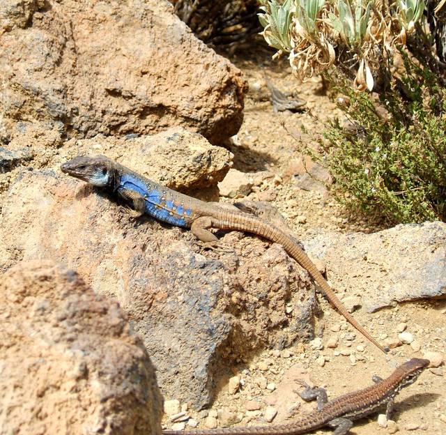 There is a huge variety of fauna as well, of which 70 species of invertebrates are only found in the park (mostly beetles and spiders). The number of vertebrates is comparatively small, with only 10 bird species nesting in the park, 3 endemic reptile species (the Canary Island lizard, the Canary Island wall gecko, and the Canary Island skink). The only endemic mammals are bats of which multiple species reside in the park. Numerous invasive mammals have been introduced, including rabbits, mice, rats, feral cats, and hedgehogs.
To climb to the summit of El Teide at 3718 m (the uppermost 168 m), special permission is essential and checked thoroughly and strictly. It can be obtained online free of cost. However, only a very limited number of permits is available for the general public. In addition, time slots are assigned, which may not align with other travel plans. Hence it is strongly recommended to get it as soon as possible, but at least two months before the planned hike. The reason given for this artificially created scarcity is conservation.
If reaching the summit is not your goal then travelling up the mountain to the cable car top station doesn't need a permit. A return ticket for the cable car costs ca. depending on whether you buy it at the ticket office or online.
- Pico de Teide. If there is no cloud cover, you have an amazing view all over the island, the neighboring Canary Islands, and if you are lucky you may even get to see the African mainland. Usually clouds develop in the morning; hence, you are best advised to get to the top as early as possible. The cable car service is often suspended because of strong winds. for a cable car ticket.
- Roque Cinchado. 24/7. Rock formation considered emblematic to Tenerife, at ca. 1,700 m below the summit of Mount Teide. It is a volcanic formation belonging it a lineup of large rock formations all of which are remnants of the former summit known as Roques García. The 27 m high rock pillar is composed of sedimentary rock layers, with its upper layers intruded by 2 sills of lava which made the upper part of the pillar more erosion resistant. Free.
- Mirador de Chío. A good viewpoint for the sunset watching.
- Mount Guajara. 24/7. A dormant volcano (2718 m) with a large crater close to its summit, accessible by road. There's an astronomical observatory along the ridge at the southern end of the crater. It's possible to hike to the summit from Vilaflor in 4 to 5 hours, starting at 1400 m. Unlike the Teide summit climb, there are no permits necessary for Mount Guajara. Free.
- White Mountain. 24/7. A parasitic cone of the Teide caldera, and with 2748 m the third tallest peak on Tenerife after Pico del Teide (3718 m) and Pico Viejo (3135 m). Free.
- Chinyero. 24/7. Volcanic cone one the slopes of El Teide, at a distance of ca. 10 km of its summit. Its height above sea level is 1556 m but due to elevation of the landscape the cone is only 60 m tall. Its last eruption occurred on 27 November 1909, and was the last volcanic eruption on Tenerife to date. An area of 2 km² was covered by lava and ash, but no humans were injured. During its previous eruption in 1706, Garachico. was heavily damaged by its lava flows. Free.
Pico de Teide. If there is no cloud cover, you have an amazing view all over the island, the neighboring Canary Islands, and if you are lucky you may even get to see the African mainland. Usually clouds develop in the morning; hence, you are best advised to get to the top as early as possible. The cable car service is often suspended because of strong winds. for a cable car ticket.
Roque Cinchado. 24/7. Rock formation considered emblematic to Tenerife, at ca. 1,700 m below the summit of Mount Teide. It is a volcanic formation belonging it a lineup of large rock formations all of which are remnants of the former summit known as Roques García. The 27 m high rock pillar is composed of sedimentary rock layers, with its upper layers intruded by 2 sills of lava which made the upper part of the pillar more erosion resistant. Free.
Mirador de Chío. A good viewpoint for the sunset watching.
Mount Guajara. 24/7. A dormant volcano (2718 m) with a large crater close to its summit, accessible by road. There's an astronomical observatory along the ridge at the southern end of the crater. It's possible to hike to the summit from [[Vilaflor]] in 4 to 5 hours, starting at 1400 m. Unlike the Teide summit climb, there are no permits necessary for Mount Guajara. Free.
White Mountain. 24/7. A parasitic cone of the Teide caldera, and with 2748 m the third tallest peak on Tenerife after Pico del Teide (3718 m) and Pico Viejo (3135 m). Free.
Chinyero. 24/7. Volcanic cone one the slopes of El Teide, at a distance of ca. 10 km of its summit. Its height above sea level is 1556 m but due to elevation of the landscape the cone is only 60 m tall. Its last eruption occurred on 27 November 1909, and was the last volcanic eruption on Tenerife to date. An area of 2 km² was covered by lava and ash, but no humans were injured. During its previous eruption in 1706, Garachico. was heavily damaged by its lava flows. Free.
- Teide Observatory, TF21. Astronomical observatory on Mount Teide at 2,390 m altitude, operated by the Instituto de Astrofísica de Canarias. Opened in 1964, it became the first major international observatory with telescopes from different countries being installed because of its superior observatory conditions. The observatory consists of multiple buildings, some of which can be visited on guided tours. €21.
There are tens of available routes, their description (in Spanish) alongside with some practical information, like trails' length and difficulty available at this link.
From the mountain station of the cable lift at the hike up to the Teide peak at can take up to 1 hour depending on your physical abilities. It requires a permission and also hold your passport with you.
In case you could not get a permission it may not come as a surprise that local tour agencies can almost always organize a tour at any given day, even on short notice. The created shortage of tickets seems to work well as a mechanism to foster organized tours instead of individual tourism. Needless to say the price for an organized tour is significantly higher.
Access to the peak is only controlled from 09:00 - 17:00 every day (first and last ride of the cable lift). If you manage to get up (and down!) to the peak before 09:00 or after 17:00 you will be able to hike to the top without a permission.
You will either have to walk up Mt. Teide by foot up or down (or both). The hike up starts at and usually takes about 5½ hours one way. It should be well prepared as there are no facilities along the way and the surrounding can be anything from sharp magma stone, snow, ice or merciless sun.
The ascent by foot starts at the base of the “Montaña Blanca”. at a parking lot on the TF-21 highway, at an altitude of (very limited parking even very early in the morning). Don't underestimate the short walk as the gradient and low oxygen levels make it challenging even for experienced walkers.
After a relatively gentle start up a 4x4 track for around 4 km, you begin the steep and spectacular climb, ascending in just over, when you will reach the recently rebuilt Altavista Refugio . This offers climbers a bed for a maximum of one (!) night and kitchen facilities. A reservation is needed and it closes early in the morning so you will need to continue the climb to the peak as early as 07:30. Alternatively you can of course take the cable lift climb down to the refuge for a sleepover.
After a and ascent, the path joins with another leading to La Fortaleza viewpoint, which follows the contour around El Teide to the cable lift. If required for descent, always check if the cable lift is operational before you set off, as it does not run in poor weather conditions and closes without warning. You should allow 6-8 hours (one way) for an ascent and descent on foot. Trailrunners can manage to run up the path in two hours, but this depends on fitness and experience.
The ascent by foot starts at the base of the “Montaña Blanca”. at a parking lot on the TF-21 highway, at an altitude of (very limited parking even very early in the morning). Don't underestimate the short walk as the gradient and low oxygen levels make it challenging even for experienced walkers.
A moderately demanding hike (hiking boots recommended) is possible from El Teide. One reasonable itinerary is leaving car at "Boca Tauce" (interesection of TF-21 and TF-38), taking bus line 342 from there to the cablecar, going up and then just descending via Pico Viejo., Narices del Teide and back to Boca Tauce. It takes around 5-6 hours from the top to bottom.
Climbing Guajara. is not restricted. The high peak can be accessed either from north (e.g. hotel Parador), which will take approximately 2 hours - or from the south. The latter is considerably more difficult, as you start at and thus expect 4-5h hike. A good base is the Vilaflor village.
Teide Observatory, TF21. Astronomical observatory on Mount Teide at 2,390 m altitude, operated by the Instituto de Astrofísica de Canarias. Opened in 1964, it became the first major international observatory with telescopes from different countries being installed because of its superior observatory conditions. The observatory consists of multiple buildings, some of which can be visited on guided tours. €21.
There is a souvenir shop. at the base station of the Teide cable car, selling exactly the same "handcrafted" souvenirs as can be found in every other souvenir shop on the island, except at a higher price: jewelry with basalt and olivine stones, ornamental decorations in lizard shapes, seeds for endemic plants, cacti, drago and pine tree saplings, post cards, and so on.
There is a souvenir shop. at the base station of the Teide cable car, selling exactly the same "handcrafted" souvenirs as can be found in every other souvenir shop on the island, except at a higher price: jewelry with basalt and olivine stones, ornamental decorations in lizard shapes, seeds for endemic plants, cacti, drago and pine tree saplings, post cards, and so on.
Options for eating are sparse in the National Park, so it is a good idea to plan ahead and pack a picnic. The same goes for water supply: it is highly unlikely to find any form of surface water on your hikes, so make sure you bring enough to stay hydrated.
There are some restaurants/bars in Portillo Alto and El Portillo at the northern edge of the National Park. In the South, Parador de los Cañadas del Teide Hotel (see sleep section) has an upper-budget restaurant with mediocre food.
There is a cafe at the lower cable car station which serves sandwiches, cakes, ice cream and coffee; buffet lunch costs . They have a monopoly on food and drinks in the park, so everything is seriouly overpriced. Check pricing of individual items before commiting to a purchase.
The upper station has neither shops nor cafés, but a coffee vending machine.
At, El Teide is the highest mountain in Spain. The rapid ascent by cable car can lead to altitude sickness. Most people come here directly from sea level, which can be stressful. If symptoms start to manifest you should descend immediately, note that at peak times the wait for the cable car descent can be over an hour. Details on what to expect can be found at Altitude sickness#Illnesses at altitude.
At the summit, strong winds are not uncommon which significantly reduces temperatures. Irrespective of temperatures on the beaches, a trip to El Teide (or even just the National Park) can be very cold, with snow at the peak common until typically March/April on average. In Winter expect a few feet of snow and ice, and strong winds so prepare accordingly.
- Icod de los Vinos - under Teide, though far by road, Cueva del Viento. is the largest lava tube cave in Europe and the fifth-largest in the world.
- Santa Cruz de Tenerife - the capital
- Puerto de la Cruz – a laid-back, more family-friendly resort with the Loro Parque Zoo
- La Orotava – a stately, beautiful city
- Playa de las Américas – with Los Cristianos and Costa Adeje, a city built for tourists
- Los Cristianos
- Anaga National Park - national park at the other part of the island
[[Icod de los Vinos]] - under Teide, though far by road, Cueva del Viento. is the largest lava tube cave in Europe and the fifth-largest in the world.
[[Santa Cruz de Tenerife]] - the capital
[[Puerto de la Cruz]] – a laid-back, more family-friendly resort with the Loro Parque Zoo
[[La Orotava]] – a stately, beautiful city
[[Playa de las Américas]] – with Los Cristianos and Costa Adeje, a city built for tourists
[[Los Cristianos]]
[[Anaga National Park]] - national park at the other part of the island