
Urho Kekkonen National Park is a national park in Finnish Lapland. With an area of 2,550 km², it is the second largest national park in Finland and was visited by 289,000 people in 2009. It has good connections and services near Saariselkä, while the backcountry is popular among wilderness backpackers. Sompio Strict Nature Reserve borders the park and is described here. Also the Kemihaara Wilderness Area borders the park.
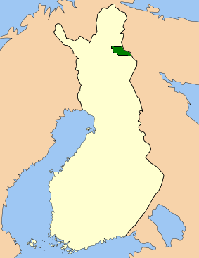
Urho Kekkonen National Park sits along the Russian border in the municipalities of Inari, Sodankylä and Savukoski. The park includes Korvatunturi, where Father Christmas lives – at least according to the Finns (yes, he has a reception in Rovaniemi, but he has to rest too). The park covers fells, broad mires and large wild forests.
The areas near the Koilliskaira Visitor Centre and near Saariselkä have lots of visitors, but outside day trip distance (and by the other entry points) the park is quite quiet and farther into the wilderness zones you will be alone most of the time, except perhaps at wilderness huts and at some common routes.
The park is partly in the Sami native region. There are exceptions in the park regulations for the Sami and for other locals.
The park was established in 1983 and is named after the former President of Finland Urho Kaleva Kekkonen ("UKK"), who was an eager hiker and cross-country skier and often came here.
There are traces of human activity in the area starting from 3000 years ago. The Forest Sami had four winter villages in the area and pitfalls and fences can be found from their era. There are also remainings of Skolt Sami villages of a later date.
In the 16th century the culture of the Forest Sami began to erode, as result of Christianizing and arriving settlers. The area became fishing, hunting and pearl fishing grounds for Finns. The wild reindeer got extinct in the 19th century. The Sami now living in the area are descendants of Norwegian Sami arriving in the 19th century with big reindeer herds.
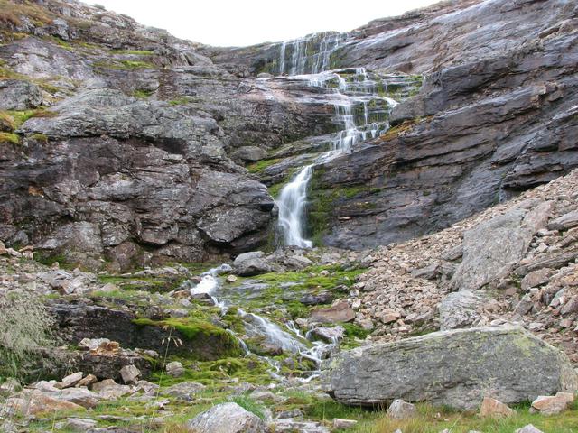
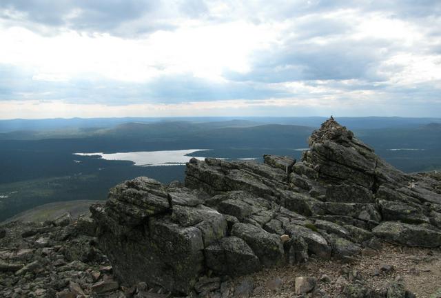
The heart of the park is the Raututunturi–Saariselkä fell area. It is easily traversed, shaped by the Ice Age, with gorges, fell heaths and boulder fields. The northern part of the park is characterised by the river-valleys of Luttojoki, Suomujoki and Muorravaarakkajoki. The southern part of the park consists of forest wilderness with pine and spruce forest and isolated fells. In the south-west there are also large open "aapa" bogs, difficult to traverse (and off-limits in the bird nesting season). The national park is a watershed area, with some rivers flowing into the Arctic Ocean, some into the Gulf of Bothnia. Kemijoki river, the longest river in Finland, originates in the park.
There is a diverse bird population in the park (130 species spotted), including several endangered species, like the gyr falcon (Falco rusticolus) and the peregrine falcon (Falco peregrinus). The golden eagle (Aquila chrysaetos) is the official emblem bird of the park. Most of the birds are migratory, the first of which return in February or early March. The most numerous birds are the brambling (Fringilla montifringilla), the willow warbler (Phylloscopus trochilus), the meadow pipit (Anthus pratensis), the redwing (Turdus iliacus) and the redpoll (Acanthis flammea). In the forests Siberian jay (Perisoreus infaustus), Siberian tit (Parus cinctus) and three-toed woodpecker (Picoides tridactylus) are commonly seen.
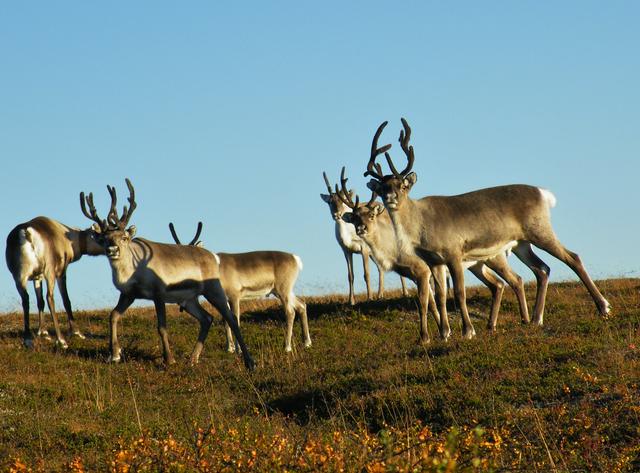
Large mammals in the park include reindeer, bear (Ursus arctos), wolverine (Gulo gulo), wolf (Canis lupus) and lynx (Lynx lynx). The large predators are seldom seen by hikers, but reindeer, hare, moose and fox are often spotted.
Some of the rivers are inhabited by the endangered freshwater pearl mussel (Margaritifera margaritifera).

The park is in inland Finnish Lapland, clearly north of the Arctic circle.
In midwinter there is Polar Night (Finnish: kaamos), with a few hours of twilight in the day and light by moon, stars and often Aurora Borealis otherwise. Temperatures can drop to -50°C (-55°F), although -20 to -30°C (-5 to -25°F) is more typical. In the fells there can be hard winds also in cold times (which is unusual in the south), adding severe wind chill.
Early spring is ideal for skiing, as the sun is bright and days become warm. Although the weather can be very nice indeed, you should be prepared for changes, especially if you go for the wilderness. Skis for prepared tracks are not suitable away from tracks, at least not if weather changes and you get lost.
In late spring all the snow is melting, which means high waters everywhere. Especially in the remoter areas experience is needed to choose feasible routes and ford unavoidable streams. Use local advice if at all unsure.
The weather is often comfortable in summer, with temperatures mostly about 20°C. It can be much colder, though. The mosquitoes arrive in late June and stay to freezing nights of August–September.
The time of autumn colours, ruska, is popular for hiking. It usually takes place in early September. Be prepared for possibly early winter.
The high season for hiking is the summer and autumn. The skiing season is in November–April. "Off season" for purpose of getting room in the huts is late autumn, midwinter and late spring.
- There are no entry or hiking fees for the park or visitor centres.
- You can sleep in your tent, in lean-to shelters and in open wilderness huts for free (see Sleep below for restrictions). Beds in reservation huts cost €11/night/person. Some huts can be reserved for a party for €25–55/night.
- For commercial camping sites outside the park you pay as normal.
- You can book a guided tour of the visitor centre or negotiate a visit outside the opening hours for a fee. Guiding for a group (max about 30 persons) €50/hour, double outside opening hours.
- Permits are required for most fishing. Fishing in flowing water requires a Metsähallitus recreational fishing permit. You can get permits at the visitor centres. Fishing is prohibited in some areas.
- Equipment can be rented from local businesses. Also guided tours and excursions are available.
The park borders Russia and there is a border zone, which should be strictly respected. To climb Korvatunturi you therefore need a special permit, but there is a trail to Korvatunturinmurusta, where you get a view. The border zone is very close at the grounds of Raja-Jooseppi, check your route carefully.
Sompio is a strict nature reserve, keep to the trails.
Entry to some (minor) areas is prohibited in the bird nesting season, 15 May to 15 July.
Leave-no-trace camping principles should be observed in most parts of the park. Although there are waste bins also in the remote areas, you should mostly carry your waste out of the park yourself. Food scraps and similar small quantities of organic waste can be put in composting toilets, where available.
- There are nature trails and exhibitions at the visitor centres.
- Natural features, e.g.:
- Iisakkipää. Fell by Saariselkä. Good views.
- Rumakuru. Two day huts at Rumakuru valley, one of which is from about 1900, probably built by gold diggers. The steep and rocky Rumakuru itself was created by the Ice Age.
- Nuorttijoki river valley. There is a circle trail (40 km) going up the river on one side and down on the other, partly by the river, partly higher up.
- Korvatunturi. Home of Father Christmas. Excursions to Korvatunturinmurusta nearby are arranged by local businesses.
- The grounds of Raja-Jooseppi. A nationally valuable cultural heritage area. The Finn Jooseppi settled here (the name means "Joseph at the border") with his wife in 1910.
- Sompio Strict Nature Reserve. Includes all the common habitats of the national park, in a smaller scale. It is on the border between the Forest Lapland and the Peräpohjola vegetation zones and the Nattaset fells rise from the spruce and pine forests to above the tree line. There are two hiking trails through the reserve (and a shorter circle trail leading by Nalijoki river and to the Pyhä-Nattanen fell top)
- Remainings of old Sami villages
There are nature trails and exhibitions at the visitor centres.
Natural features, e.g.:
- Iisakkipää. Fell by Saariselkä. Good views.
- Rumakuru. Two day huts at Rumakuru valley, one of which is from about 1900, probably built by gold diggers. The steep and rocky Rumakuru itself was created by the Ice Age.
- Nuorttijoki river valley. There is a circle trail (40 km) going up the river on one side and down on the other, partly by the river, partly higher up.
Korvatunturi. Home of Father Christmas. Excursions to Korvatunturinmurusta nearby are arranged by local businesses.
The grounds of Raja-Jooseppi. A nationally valuable cultural heritage area. The Finn Jooseppi settled here (the name means "Joseph at the border") with his wife in 1910.
Sompio Strict Nature Reserve. Includes all the common habitats of the national park, in a smaller scale. It is on the border between the Forest Lapland and the Peräpohjola vegetation zones and the Nattaset fells rise from the spruce and pine forests to above the tree line. There are two hiking trails through the reserve (and a shorter circle trail leading by Nalijoki river and to the Pyhä-Nattanen fell top)
Remainings of old Sami villages
- Hiking. There are 200 km of marked in the Saariselkä–Kiilopää region, 100 km of which are in the national park. There are a few marked trails in other parts of the park. Some trails (see also some hiking trails, some more):
- Nuorttijoki marked hiking trail. 40 km circle route along Nuorttijoki river at the south-eastern corner of the park, 2×12 km more if you use the UKK trail to get from Tulppio to the trailhead. The ford at Haukinivat is too dangerous at high waters, ask about the current situation at the visitor centre.
- Kiilopää–Suomuruoktu–Tuiskukuru–Luirojärvi–Lankojärvi–Kiilopää. 70–80 km trail, not marked, but one of the most popular routes, with huts and campfire sites. Includes a few fords.
- Raja-Jooseppi–Suomujoki–Kiilopää. 70–80 km trail, also not marked but with huts and campfire sites. In the first part of the route there are buildings of Skolt Sami families, who were evacuated from Petsamo after the war (and later settled at Sevettijärvi
- Ruijanpolku. 35 km trail through Sompio to Laanila, part of the former trail between Bothnian Bay and the coast of Finnmark (Finnish: Ruija) at the Arctic Ocean. It is mentioned as early as in the 16th century, but fell in disuse at the beginning of the 19th century. This section is now a marked hiking trail (some of the historic markings remain).
- Korvatunturi marked hiking trail. 20 km (one way) from Keminhaara to Korvatunturinmurusta, with view to Korvatunturi.
- Sompiojärventie–Nalijoki–Tankavaara trail. Through Sompio Strict Nature Reserve, 17–20 km, to Tankavaara or to Männistö village. Features the Pyhä-Nattanen fell.
- Cross-country skiing.
- There are 250 km of cross-country skiing tracks in the winter, 25 km of which are lit (skiing trails overview map, PDF ). Most are suitable both for classic and freestyle skiing.
- You can also ski farther into the wilderness with a backpack. Suitable skills, skis and equipment needed. Less experienced visitors can do similar expeditions with a guide. On some routes snowmobile assistance is allowed.
- Canoeing, kayaking
- Biking is allowed by the following routes:
- Saariselkä–Luttotupa
- Raja-Jooseppi–Anteri
- Kemihaara–Mantoselkä and
- Kemihaara–Vieriharju.
- Fishing. Contact the visitor centres or local businesses for advice and requirements.
[[Hiking in the Nordic countries|Hiking]]. There are 200 km of marked in the Saariselkä–Kiilopää region, 100 km of which are in the national park. There are a few marked trails in other parts of the park. Some trails (see also some hiking trails, some more):
- Nuorttijoki marked hiking trail. 40 km circle route along Nuorttijoki river at the south-eastern corner of the park, 2×12 km more if you use the UKK trail to get from Tulppio to the trailhead. The ford at Haukinivat is too dangerous at high waters, ask about the current situation at the visitor centre.
- Kiilopää–Suomuruoktu–Tuiskukuru–Luirojärvi–Lankojärvi–Kiilopää. 70–80 km trail, not marked, but one of the most popular routes, with huts and campfire sites. Includes a few fords.
- Raja-Jooseppi–Suomujoki–Kiilopää. 70–80 km trail, also not marked but with huts and campfire sites. In the first part of the route there are buildings of Skolt Sami families, who were evacuated from Petsamo after the war (and later settled at [[Sevettijärvi]]
- Ruijanpolku. 35 km trail through Sompio to Laanila, part of the former trail between Bothnian Bay and the coast of [[Finnmark]] (Finnish: Ruija) at the Arctic Ocean. It is mentioned as early as in the 16th century, but fell in disuse at the beginning of the 19th century. This section is now a marked hiking trail (some of the historic markings remain).
- Korvatunturi marked hiking trail. 20 km (one way) from Keminhaara to Korvatunturinmurusta, with view to Korvatunturi.
- Sompiojärventie–Nalijoki–Tankavaara trail. Through Sompio Strict Nature Reserve, 17–20 km, to Tankavaara or to Männistö village. Features the Pyhä-Nattanen fell.
Supplies are available at Saariselkä and in the villages of Savukoski, Vuotso and Tulppio (?). These are not towns but small villages, so check beforehand if you want or need something special.
At Saariselkä there is a supermarket and an outdoor equipments' store.
- Supermarket Kuukkeli, Saariseläntie, +358 16 668-741. 9-21.
- Partioaitta, Honkapolku, +358 10-549-4800.
Savukoski, two supermarkets:
- K-market Heinäjärvi, +358 16 841-274. M–F 9:00–18:00, Sat 9–16, Sun 12–16. Also e.g. post and fuel.
- Sale Savukoski, +358 10-763-3501.
Vuotso:
- K-extra Sieppi, Säpikästie 3, +358 400-214-655. M-F 8:30–18:00, Sat 9:00–14:00, Sun 11:00–14:00.
Supermarket Kuukkeli, Saariseläntie, +358 16 668-741. 9-21.
Partioaitta, Honkapolku, +358 10-549-4800.
K-market Heinäjärvi, +358 16 841-274. M–F 9:00–18:00, Sat 9–16, Sun 12–16. Also e.g. post and fuel.
Sale Savukoski, +358 10-763-3501.
K-extra Sieppi, Säpikästie 3, +358 400-214-655. M-F 8:30–18:00, Sat 9:00–14:00, Sun 11:00–14:00.
There are restaurants and cafés especially in the Saariselkä area, but also in the other villages around the park. Some tourist businesses offer meals in the park by agreement.
There are stoves for preparing food in the wilderness huts. Take own pots, pans and cutlery with you, unless you have checked that what you need is provided.
In the Basic Zone, the Saariselkä wilderness zone and the Nuortti wilderness zone making fire is allowed only at the specially designated campfire sites (e.g. at the lean-to and cooking shelters). In the Kemi–Sompio wilderness area lighting fires using twigs and branches found on the ground is allowed. When there is a forest fire warning in effect, open fire is prohibited everywhere. In really dry periods fire should be avoided even in huts (the gas stove in huts can be used for cooking).
Carry a camping stove on any longer hikes. It can be used (with due care) also during wildfire warnings.
The water in ponds, streams and rivers should be potable, but it has not been tested. To be safe you might want to boil it. There is water available at the visitor centres and customer service points.
General advice for wilderness hikes in Lapland apply.
The weather may change rapidly on the fells. Be prepared for fog or storm.
Always take a good map, compass, knife and matches with you, even on the shortest day trips along marked trails. Prepare well and do not go without experienced enough company. GPS is no substitute for orienteering skills and a map.
Tell about your plans to a friend or e.g to the visitor centre (including a dead line when a rescue operation should be started). Tell about any changes to the plans and remember to tell when you do return. Use the guest books.
There are areas in the park without mobile phone coverage. Try fell tops. The emergency number 112 can use any provider, remove the SIM card if necessary.
A 9V battery for the fire alarms of the huts may be needed.
Beware of avalanches at gorges.
- Tankavaara, the gold rush museum
- Hammastunturi Wilderness Area on the other side of the Inari road, towards Lemmenjoki National Park
- UKK trail, leading from Tulppio all the way to Koli National Park, or at least to Ruka (350 km). From Hautajärvi it follows the Karhunkierros trail. From Ruka southwards documentation is partly lacking and some sections not maintained.
- Vätsäri Wilderness Area and Øvre Pasvik National Park in the Pasvik–Inari Trilateral Park