
Yonaguni (与那国) in the Yaeyama Islands is the westernmost point of Japan.
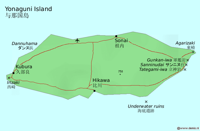
Also known as Dunan (どぅなん) in the local language, Yonaguni is a small island (28 km2) from Taiwan and from Ishigaki. The main population centers are Sonai (祖内) on the north coast, the smaller port town of Kubura (久部良) on the west coast, and tiny Hikawa (比川) in the south. The total population is about 1700.
Although it lacks the resorts of the larger Yaeyama islands and its few visitors are mostly divers coming to witness the island's mysterious sunken "ruins" and hammerhead sharks, the island has beautiful (yet uncrowded) beaches, cultural attractions, and various mysteries of history.
Yonaguni is famous for its local language, brewed in isolation for centuries, which even those from mainland Okinawa find utterly incomprehensible. Pronunciation can be a bit easier than that of the neighboring Miyako islands, though, as the central vowels and word-final consonants are absent here. Language buffs can pick up Nae Ikema's Japanese-Yonaguni dictionary Yonaguni-go Jiten (与那国語辞典) at the airport shop.
The only words the casual visitor is likely to run into though are waːriː (ワーリー) and fugarassa (フガラッサ), Yonaguni for "welcome" and "thank you", respectively, as standard Japanese is spoken by practically everybody (the locals are bilingual), and Chinese is understood by some as Taiwanese TV and radio can be picked up on the island.
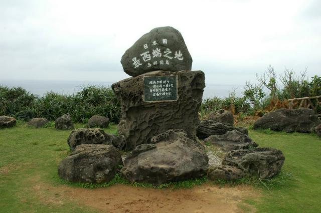
- Cape Irizaki. Yonaguni's main aboveground sight of any interest is the marker for the westernmost point of Japan (日本最西端の碑) at the westernmost tip of the island, about a kilometer from Kubura (15 minutes on foot).
- Cape Agarizaki, at the east tip of the island. The kanji mean East Cape, but the reading of the name refers to the rising sun. You can observe it from a cliff. On a clear day, if you're lucky, you can see the coast of Iriomote. Also a grazing area, many Yonaguni horses can be found here.
- Kuburabari. This cliff near the northern side of Kubura's port offers views of the last sunset in Japan, and on a good day it is possible to see the shadow cast by Taiwan in front of the setting sun from here. This is also the site where, in the rough period when residents of the island were forced to pay an alarmingly expensive head tax after the Ryukyu Kingdom was conquered by the Satsuma clan from the Japanese mainland, pregnant women were sometimes made to jump to their death to avoid an increase in population.
- Ubudumaihama. From the cliffs here, there's an impressive view of much of Yonaguni's beautiful northern coastline.
- Hikawa Beach, the southern shore of the island in Hikawa. Shaped like a crescent, it is the island's largest beach. Suitable for swimming. Very quiet, little-to-no waves because of a coral reef.
Cape Irizaki. Yonaguni's main aboveground sight of any interest is the marker for the westernmost point of Japan (日本最西端の碑) at the westernmost tip of the island, about a kilometer from Kubura (15 minutes on foot).
Cape Agarizaki, at the east tip of the island. The kanji mean East Cape, but the reading of the name refers to the rising sun. You can observe it from a cliff. On a clear day, if you're lucky, you can see the coast of [[Iriomote]]. Also a grazing area, many Yonaguni horses can be found here.
Kuburabari. This cliff near the northern side of Kubura's port offers views of the last sunset in Japan, and on a good day it is possible to see the shadow cast by [[Taiwan]] in front of the setting sun from here. This is also the site where, in the rough period when residents of the island were forced to pay an alarmingly expensive head tax after the Ryukyu Kingdom was conquered by the Satsuma clan from the Japanese mainland, pregnant women were sometimes made to jump to their death to avoid an increase in population.
Ubudumaihama. From the cliffs here, there's an impressive view of much of Yonaguni's beautiful northern coastline.
Hikawa Beach, the southern shore of the island in Hikawa. Shaped like a crescent, it is the island's largest beach. Suitable for swimming. Very quiet, little-to-no waves because of a coral reef.
- Kuburadake. Kuburadake is a Natural Conservation District in the west of Yonaguni, about above sealevel. It is valuable because it contains a Chinquapin mountain forest and a lowlands forest, home to such natural monuments as the colorful Emerald Dove (リュウキュウキンバト), Japanese Wood Pidgeon (ヨナグニカラスバト), Ryukyu Robin (ウスアカヒゲ), and others. From about halfway up the mountain to the summit, the trees are mostly date palms. Lower than halfway, you can find Javanese bishopwood trees (アカギ) and other diverse plants which the Atlas moth eats.
- Tindabana. Tindabana is a natural rock formation with a nice view. About tall. From Tindabana, you can see the entire village of Sonai, and Nandahama. According to tradition, the great empress of Yonaguni, Sanai Isoba, resided here.
- Jinmen-iwa. Jinmen-iwa is a big rock in the forest that resembles a human face. Requires 12-20 minute hike up the hill by a forest trail. No parking, nearest parking is at Tatigami-iwa.
The following rock formations are best viewed by boat.
- Gunkan-iwa. The "Battleship Rock", about south of Agarizaki, is a series of peculiarly-shaped reef rock formations. Supposedly, the main rock bears a close resemblance to the shape of a battleship, and that's how it got it's name. It can be observed from Sanninudai.
- Sanninudai. Believed by some to be an above-water portion of the mysterious undersea ruins because it is shaped almost like a sort of stairway. The strangely-shaped rocks of Gunkaniwa can be easily seen from here. Also, there's a rock here with some writing on it which is mysterious. It bears little resemblance to kaida-dii, the island's indigenous writing system, and some have even suggested that it is Phoenecian.
- Tatigamiiwa. The "Standing God Rock", at the southeast tip of the island, is also noted for the underwater ruins nearby (see Do, some with what appears to be indigenous writing. Also, it's considered a spiritual site for followers of Yonaguni's indigenous traditional religion.
Kuburadake. Kuburadake is a Natural Conservation District in the west of Yonaguni, about above sealevel. It is valuable because it contains a Chinquapin mountain forest and a lowlands forest, home to such natural monuments as the colorful Emerald Dove (リュウキュウキンバト), Japanese Wood Pidgeon (ヨナグニカラスバト), Ryukyu Robin (ウスアカヒゲ), and others. From about halfway up the mountain to the summit, the trees are mostly date palms. Lower than halfway, you can find Javanese bishopwood trees (アカギ) and other diverse plants which the Atlas moth eats.
Tindabana. Tindabana is a natural rock formation with a nice view. About tall. From Tindabana, you can see the entire village of Sonai, and Nandahama. According to tradition, the great empress of Yonaguni, Sanai Isoba, resided here.
Jinmen-iwa. Jinmen-iwa is a big rock in the forest that resembles a human face. Requires 12-20 minute hike up the hill by a forest trail. No parking, nearest parking is at Tatigami-iwa.
Gunkan-iwa. The "Battleship Rock", about south of Agarizaki, is a series of peculiarly-shaped reef rock formations. Supposedly, the main rock bears a close resemblance to the shape of a battleship, and that's how it got it's name. It can be observed from Sanninudai.
Sanninudai. Believed by some to be an above-water portion of the mysterious undersea ruins because it is shaped almost like a sort of stairway. The strangely-shaped rocks of Gunkaniwa can be easily seen from here. Also, there's a rock here with some writing on it which is mysterious. It bears little resemblance to kaida-dii, the island's indigenous writing system, and some have even suggested that it is Phoenecian.
Tatigamiiwa. The "Standing God Rock", at the southeast tip of the island, is also noted for the underwater ruins nearby (see [[#Do|Do]], some with what appears to be indigenous writing. Also, it's considered a spiritual site for followers of Yonaguni's indigenous traditional religion.
- Tunguta. Tunguta is a rice field in the middle of the island, of historical interest. In the period when a head tax was enforced by the Shimazu clan of modern-day Kagoshima prefecture against the people of the southern islands, causing much pain and suffering, all the inhabitants of the island were suddenly called to this ricefield. Those who did not get there by a certain time were slaughtered. This was one of a few horrific stories of population reduction which was carried out on Yonaguni by the order of the local elders.
- Yonaguni Ethnographic Museum. This museum, at No. 49 in the Sonai area, is run by 87-year-old "island auntie", Ikema Nae. There's a lot of information about the island's history, culture, and even language. If you want information about the island's indigenous writing system, kaida-dii, this is probably the place to go. Their informational pamphlets can also be very enlightening, but they are only occasionally offered in English. The museum also sells the Dictionary of the Yonaguni Tongue (与那国語辞典 Yonaguni kotoba jiten), the only available dictionary of the local language (to and from Standard Japanese), also with a little bit of information about the native writing system. Incidentally, the dictionary is written by Ms Nae, and the entire museum is mostly the result of her work. If you have any questions, she's usually there and is very knowledgable about the history, culture, language, and traditions of Yonaguni.
- Bullfights (闘牛)
Tunguta. Tunguta is a rice field in the middle of the island, of historical interest. In the period when a head tax was enforced by the Shimazu clan of modern-day Kagoshima prefecture against the people of the southern islands, causing much pain and suffering, all the inhabitants of the island were suddenly called to this ricefield. Those who did not get there by a certain time were slaughtered. This was one of a few horrific stories of population reduction which was carried out on Yonaguni by the order of the local elders.
Yonaguni Ethnographic Museum. This museum, at No. 49 in the Sonai area, is run by 87-year-old "island auntie", Ikema Nae. There's a lot of information about the island's history, culture, and even language. If you want information about the island's indigenous writing system, kaida-dii, this is probably the place to go. Their informational pamphlets can also be very enlightening, but they are only occasionally offered in English. The museum also sells the Dictionary of the Yonaguni Tongue (与那国語辞典 Yonaguni kotoba jiten), the only available dictionary of the local language (to and from Standard Japanese), also with a little bit of information about the native writing system. Incidentally, the dictionary is written by Ms Nae, and the entire museum is mostly the result of her work. If you have any questions, she's usually there and is very knowledgable about the history, culture, language, and traditions of Yonaguni.
Bullfights (闘牛)
The island's unique fauna are also of interest.
- Yonaguni horse (ヨナグニウマ yonaguni-uma). Bred in isolation on Yonaguni over hundreds of years, the Yonaguni horse is a very small breed, only about 10 hands high (100 cm/3.5 feet). Nowadays, most are wild, in two free-ranging herds (about 108 horses total). They're generally very tame and gentle, thanks in large part to the kind treatment they receive from the islanders. You'll probably see at least one if you're on the island for very long.
- Atlas moth (ヨナグニサン yonaguni-san). The largest known species of moth in the world. Although it can be found in other parts of Asia (mostly in Taiwan, India, and Malaysia), the first specimen was collected in Yonaguni and they are abundant.
- Atlas Moth Museum. Has live caterpillars in season as well as various displays of local insects and other critters. You won't be able to see the adult moths, though, as the cocoons are returned to the forests.
- Geographer Cone. A very beautiful — but also very poisonous — seashell. See here for more information on how to watch out for them.
Yonaguni horse (ヨナグニウマ yonaguni-uma). Bred in isolation on Yonaguni over hundreds of years, the Yonaguni horse is a very small breed, only about 10 hands high (100 cm/3.5 feet). Nowadays, most are wild, in two free-ranging herds (about 108 horses total). They're generally very tame and gentle, thanks in large part to the kind treatment they receive from the islanders. You'll probably see at least one if you're on the island for very long.
Atlas moth (ヨナグニサン yonaguni-san). The largest known species of moth in the world. Although it can be found in other parts of Asia (mostly in Taiwan, India, and Malaysia), the first specimen was collected in Yonaguni and they are abundant.
- Atlas Moth Museum. Has live caterpillars in season as well as various displays of local insects and other critters. You won't be able to see the adult moths, though, as the cocoons are returned to the forests.
Geographer Cone. A very beautiful — but also very poisonous — seashell. See [[#Stay safe|here]] for more information on how to watch out for them.
Scuba diving is without a doubt the main draw for most visitors to Yonaguni. However, the island's location in the middle of the open sea without protective reefs means that waves can be high and currents can be strong, so most diving here is drift diving and many of the more interesting dive sites are only accessible to experienced divers.
- Open Coast Travel, Los Angles, CA., +1-310-433-6653 (USA number). Open Coast Travel is the only US based travel agency specializing in guided scuba tours to Yonaguni for western travelers. All bilingual guides have lived in Japan.
- Yonaguni Diving Service, +81 980-87-2658. Kubura. The oldest and largest dive shop on the island, quite professionally run: they will cater to your experience level and will not head out to sites if the weather does not permit (in which case your money is refunded). Two boat dives start from, full gear rental for a day is . No credit cards accepted and only limited English spoken. Quite popular, so book ahead.
- SOUWES Diving Service, +81 980-87-2311. Yonaguni. The dive shop of Mr. Kihachiro Aratake. Mr. Kihachiro Aratake is a diving instructor who first discovered the underwater ruins.
Snorkeling is possible in from some beaches, and can be quite good, though there may not be any spot ideal for beginners. The sheltered channel on the east side of the bridge at Sonai harbor is a relatively safe place to swim around and see some tropical fish, best accessed from a tiny beach near Urano Cemetery. There can be a significant current here during the changing tides, but there's nowhere for you to get pulled out to - you'll either end up at the boat ramp or back at the beach. The outer lagoon on the other side of the concrete reinforcements is even better, but you should be very careful of currents and high surf. Never swim in the ocean without first learning what to do if you get caught in a rip current.
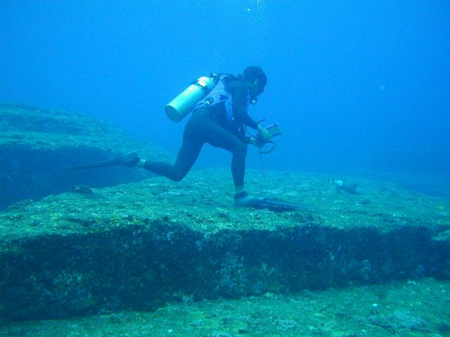
Yonaguni's unique attraction is the mysterious "underwater ruins". Dryly but diplomatically referred to by the government as the "Underwater Landscape Resources" - which lie off the southern coast of the island. A single platform 100by wide and up to tall, seeming carved out of solid rock at perfectly right angles and dated by some to be 8000 years old, the technology required to build them here doesn't seem to match any known timeline of human history. Some maintain that they are the product of the lost Continent of Mu or even alien artifacts, though the majority of scientists think they were created by natural geological processes. But the (apparent) hallways and staircases, as well as what appear to be regular rows of holes dug for moving rock and even what some take to be a form of writing on the walls, keep visitors intrigued.
Seeing the ruins, however, takes some time, effort and skill: the area is notorious for its currents and not suitable for beginning divers, although several diving shops run one-day crash courses that culminate in a guided tour of the ruins. For those with the requisite skills (PADI AOWD or more), a day's diving starts at . The ruins, some 20 minutes by boat from Kubura, are usually only accessible when they are on the leeward side of a north wind and the currents are not too strong, so you'll also need some luck just to get here.
Wind conditions permitting, SOUWES diving service can also arrange glass-bottomed boats to make the trip for /head if there are five or more passengers (or you can charter the whole boat yourself). Don't expect to see very much when the weather is bad, as the ruins are at a depth of 5to.
The names of individual features are mostly made up by their original discoverers and researchers. They might not be scientifically correct, but no better names are available for reliable orientation.
- Arch Gate. A passage 1m in width and 2m in height that looks like a tunnel.
- Twin Megaliths. Two huge stone slabs standing parallel to each other.
- Main Terrace. Relatively wide flat area with vertical wall.
- Main Terrace Stairs. Formation that looks like giant stairs at the Main Terrace. There are some photos of these stairs on the internet, taken here from a specific angle, such that the stairs look like a pyramid going up high. In reality that is not the case.
- Loop Road. A 5m wide ledge that encircles the base of the formation on three sides.
- Retaining Wall. A straight row of huge stones along the south (outer) edge of the "Loop Road".
- Water Trench. A long narrow cavity with flat parallel walls that looks like a water trench.
- Triangle Pool. A triangular depression with three large holes at its north edge.
- Turtle Monument. A low star-shaped platform.
These objects are not part of the monument, but are relatively close to it:
- Totem. A stone column about 7m tall, to the south of the monument.
- Sun Stone. An isolated boulder was resting on a low platform to the east of the monument. That boulder has been washed away from the platform.
Yonaguni's unique attraction is the mysterious "underwater ruins". Dryly but diplomatically referred to by the government as the "Underwater Landscape Resources" - which lie off the southern coast of the island. A single platform 100by wide and up to tall, seeming carved out of solid rock at perfectly right angles and dated by some to be 8000 years old, the technology required to build them here doesn't seem to match any known timeline of human history. Some maintain that they are the product of the lost Continent of Mu or even alien artifacts, though the majority of scientists think they were created by natural geological processes. But the (apparent) hallways and staircases, as well as what appear to be regular rows of holes dug for moving rock and even what some take to be a form of writing on the walls, keep visitors intrigued.
Arch Gate. A passage 1m in width and 2m in height that looks like a tunnel.
Twin Megaliths. Two huge stone slabs standing parallel to each other.
Main Terrace. Relatively wide flat area with vertical wall.
Main Terrace Stairs. Formation that looks like giant stairs at the Main Terrace. There are some photos of these stairs on the internet, taken here from a specific angle, such that the stairs look like a pyramid going up high. In reality that is not the case.
Loop Road. A 5m wide ledge that encircles the base of the formation on three sides.
Retaining Wall. A straight row of huge stones along the south (outer) edge of the "Loop Road".
Water Trench. A long narrow cavity with flat parallel walls that looks like a water trench.
Triangle Pool. A triangular depression with three large holes at its north edge.
Turtle Monument. A low star-shaped platform.
Totem. A stone column about 7m tall, to the south of the monument.
Sun Stone. An isolated boulder was resting on a low platform to the east of the monument. That boulder has been washed away from the platform.
In addition to the ruins, Yonaguni is also famous among Japanese divers for its hammerhead sharks, which congregate around the island and can be spotted on most dives in the cooler winter season (December–February). Yonaguni is also pretty much the only spot in Japan where it is possible to spot the giant whale shark, the largest of them all, although sightings are quite rare.
Much of the southern coastline is dotted with caverns, caves and underwater rock formations, which make for spectacular but, again, slightly challenging diving. Daiyati and the Temple of Light are particularly well-known spots that bear more than slight resemblance to Swiss cheese.
Other events of note on Yonaguni include:
- Swordfish Fishing Competition. Yearly in July.
- Yonaguni Marathon. Every November. Despite the name, the race is either or (around the island), not a full marathon.
Swordfish Fishing Competition. Yearly in July.
Yonaguni Marathon. Every November. Despite the name, the race is either or (around the island), not a full marathon.
Open Coast Travel, Los Angles, CA., +1-310-433-6653 (USA number). Open Coast Travel is the only US based travel agency specializing in guided scuba tours to Yonaguni for western travelers. All bilingual guides have lived in Japan.
Yonaguni Diving Service, +81 980-87-2658. Kubura. The oldest and largest dive shop on the island, quite professionally run: they will cater to your experience level and will not head out to sites if the weather does not permit (in which case your money is refunded). Two boat dives start from, full gear rental for a day is . No credit cards accepted and only limited English spoken. Quite popular, so book ahead.
SOUWES Diving Service, +81 980-87-2311. Yonaguni. The dive shop of Mr. Kihachiro Aratake. Mr. Kihachiro Aratake is a diving instructor who first discovered the underwater ruins.
The most popular Yonagunian souvenir by far is hanazake (花酒) liquor, see Drink for details.
- Ōasa Shoten. One of Kubura's two general-goods stores. Has a pretty good range of hanazake tucked away in the back.
- Yonaguni Kaien. This store sells salt harvested from Kuroshio Current. The best stuff comes in big crystals several millimeters in size, and supposedly tastes somewhat sweet.
Ōasa Shoten. One of Kubura's two general-goods stores. Has a pretty good range of hanazake tucked away in the back.
Yonaguni Kaien. This store sells salt harvested from Kuroshio Current. The best stuff comes in big crystals several millimeters in size, and supposedly tastes somewhat sweet.
Most visitors opt to eat breakfast and dinner at their lodgings and lunch at their diving service, but there are a few small restaurants in Sonai and Kubura, as well as a small "supermarket" in Sonai.
- Shokujidokoro Hiko, in Kubura. W-M 9AM-10PM.
- Maruki Shokudō, in Sonai, +81 737-82-2256. Famous far and wide for its chōmei-sō soba (長命草そば), which contains a local grass reputed to extend longevity.
Shokujidokoro Hiko, in Kubura. W-M 9AM-10PM.
Maruki Shokudō, in Sonai, +81 737-82-2256. Famous far and wide for its chōmei-sō soba (長命草そば), which contains a local grass reputed to extend longevity.
Yonaguni is best known for hanazake (花酒), literally "flower sake", a drink nowhere near as dainty as you might expect from the name: it's the local 60° awamori and tradition demands drinking it straight, without even an ice cube to ease the pain. The best known brand is Donan (どなん) and the other labels brewed on the island are Yonaguni (与那国) and Maifuna (舞富名, ateji) meaning 'clever person' in the local dialect). You can visit the breweries of all three in Sonai, sample a little, and learn about brewing methods. It's fairly steeply priced though, as a bottle of the stuff will set you back over ; and you need to add a few hundred yen if you want the traditional protective straw coat for your bottle. Cheaper and marginally less lethal 43° and 30° versions are also available.
Okinawa's favorite bogeyman, the habu snake, is absent from Yonaguni. The main danger here is the ferocious currents, particularly on the north coast, so check conditions before swimming. Other than that, the usual warnings apply not to touch any seas creatures (including beautiful cone shells), some of which have stings that can occasionally be fatal.
There are no banks on Yonaguni, but you can withdraw money from the ATMs at the post offices in Sonai and Kubura. There are no convenience stores either. The supermarket in Sonai stays open until 20:00, and for dinner there is at least one izakaya in Sonai that stays open until 21:00 or 22:00.
There are no public WiFi hotspots on Yonaguni yet, but your accommodation should have fast WiFi for guests.
You're at the end of the earth now — unless you can score a seat to Taiwan on a private boat, the only way out is back where you came from.