

Salar de Uyuni is the largest salt flat in the world and one of the most amazing natural attractions of Bolivia. Whether you're walking on the seemingly endless white, desolate surface of the dry flats, or admiring the simply perfect reflection of the clouds and blue sky above when there's water - all travellers agree the Salar de Uyuni offers an out-of-this-world experience. The flats cover an area of over 10,000 km² and to see the best parts, you'll need to cover quite some ground. While it's possible to explore this unique piece of land on your own, most visitors opt for multiple-day organized tours along some of the best sights.
The Salar is part of the Bolivian Altiplano, and its history began when that high plateau emerged as a result of uplift of the Andes. About 30,000 to 42,000 years ago, the area that is now the Salar de Uyuni was a huge, deep lake known as Lake Minchin. As Lake Michin dried up, it left smaller lakes behind, which in turn dried up until two current-day lakes and two salt deserts remained, of which the Salar the Uyuni is the largest one. One of those two lakes, called Poopó, still has a major impact on Salar de Uyuni. As Titicaca, another large current-day lake of the Altiplano, overflows during wet season, it fills up lake Poopó. As Poopó overflows in turn, it floods the salt flats - creating the stunning landscapes of winter, when a thin layer of water creates magical reflections of the sky and anything or anyone on the flats. The area is biggest lithium reserve of earth - containing some 70% of world's lithium in form of salt. Yearly, around 25,000 tonnes of salt are mined here, out of estimated 10 billion tonnes.
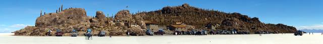
Thanks to the sedimented salt, the area is perfectly flat - which is often used for various technical purposes . In the middle is Isla del Pescado - a volcanic rock. It provides great views and is a natural reservation.

There isn't much flora, mostly just grass and bush. The Isla del Pescado is covered by an ancient cacti forest – cacti like Echinopsis atacamensis pasacana and Echinopsis tarijensis, which grew up to 12 meters high. The cacti grow at pace of 1cm per year, hence their age is up to 1000 years. In November, three types of flamingoes flock here. 80 other bird species are present, and few other small animals.
Very little rain happens in the area, but yearly flooding occurs, mostly in January. At that time the whole area changes to a world's highest altitude mirror. After the water evaporates, bee-hive-like polygons cover the area. Temperature peaks at 21°C in November-January, and 13° in June. Nights are cold all through the year, -9 to 5°C. Rainfall outside January is almost non-existent.
No fees or permits are required to enter the salt area.
- Train Graveyard. The famous lot of old wrecked steam locomotives
- Colchani, Bloques de Sal. A salt processing village, 7 km north of Uyuni. Salt souvenirs and museums available.
- Salt-Mining Area. Area with many salt piles, weighing approximately a ton each, which are left there to dry.
- Isla del Pescado. The island of fossilized coral, covered in ancient cacti. Lunch is eaten by most tour groups on the western "shore" of this island Bs30.
- Pulacayo. Nearby world's second largest silver mine, at this historical site there's the Bolivia's first rail road and a train robbed by Butch Cassidy and the Sundance Kid.
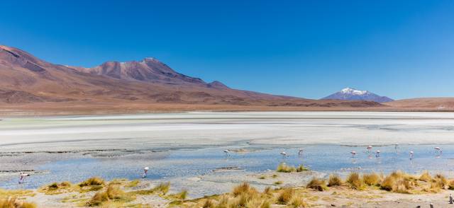
- Laguna Hedionda. A lagoon where the flamingos can be observed.
- Viscacha Area. A rocky outcropping with a colony of Viscachas, trained by the guides to come out for the food
- Arbol de Piedra. "Stone tree", an isolated sandstone formation eroded by winds carrying sand.
- Laguna Colorada. A red-coloured lake, by algae, with flamingoes present too. Bs30 (Bolivian citizen), Bs150 (foreigner) to enter Reserva Nacional de Fauna Andina Eduardo Avaroa..
- Sol de Manaña. A geyser basin, including bubbling sulphur pools, normally visited at sunrise
- Laguna Verde. A lake colored by heavy metals (Arsenic, Lead, Copper etc.). The laguna only shows green when it's windy, which is often not the case in the early morning (common visit time of tours) Vulcán Lincacabur. is reflected in the lake.
- Laguna Blanca. A borax-filled white lake
- Laguna Celeste. A lake at the foot of the Uturuncu. volcano, called according to the color of its clear blue water (caused by magnesium and manganese). Andean flamingos feed and form large flocks here.
- Laguna Amarilla. A yellow lake, colored by sulphur, with old cave paintings nearby
- San Antonio ruins. An abandoned 16th century mining town, where slave labour was used. Guides provide different stories why it's no longer inhabited. An equally named village is nearby, but it's not overlooked by the ominous volcano Uturuncu
- Valles de Rocas. As the name says - valleys of rocks, The guides will do the common thing - try to point out some look-alike objects.
- Sillar. Giant columns of clay nearby Tupiza, which were formed by erosion
- San Cristobal. A town nearby the homonymous mine - one of the largest mine facilities in Bolivia. The town was formerly nearby the mine, but was completely moved to a this area. There was a 350-year-old church in the city - it was not destroyed, but instead transported and rebuilt stone-by-stone at the new spot, including the cemetery. The altar within is made of silver - likely because the mine is 3rd largest silver producer of the world.
- Termas de Polques hot springs. Adjacent to Salar de Chalviri, allowing for hot spring swim. Primitive bathrooms available for 6B.
The tours sometimes bring not enough water supply. Get informed, you may need to take 2L more per day.

In the tours, drunk drivers are a possibility - do not risk if you have a suspicion. Taking emergency supplies is advisable if undertaking a private trip. With organized tours, most follow the same path - thus another truck will meet you in minutes. Keep in mind that you will be travelling at high altitudes. Make sure to take necessary precautions to prevent altitude sickness. Take the time to get acclimated and educate yourself on the symptoms, methods of prevention and treatments. The German embassy in La Paz is said to already have a "storage room" for deceased because of the casualities. Highest visited point of the area is 5000m, and sleeping at 4200m - in this regard, it's better to start from Uyuni than from Tupiza (3000m).