
Kilpisjärvi (Sámi: Gibbesjávri) is a small village in Enontekiö on the top of Finland's "arm", the only real alpine village in Finland. Several sights are located in Kilpisjärvi or nearby. The village has about a hundred inhabitants.
The village is at the lake Kilpisjärvi, from which it got its name. The fell Saana above the village is the only fell in Finland that is over 1000 m and not in the nearby Käsivarsi Wilderness Area.
Kilpisjärvi is one of the coldest inhabited places in Finland (and Europe), with an average temperature somewhat beneath freezing (average in January -14°C, in July +11°C). There is polar night for nearly two months in midwinter and corresponding midnight sun most of the summer. The maximum official Finnish snow depth, 1,9 metres, has been recorded at the Kilpisjärvi weather station. The snow in the fell birch forests usually melts in early June, the ice of the lake just before Midsummer.
The old Finnish bedrock meats the younger Scandinavian mountains in the area, which makes it geologically interesting.
Pieces of earthenware from 4500 BC have been found by the lake. There are signs of buildings by Saana from the 16th century, when traders stopped here on their way to the market in Skibotn. In the 17th century large scale reindeer husbandry was introduced in the area. Finns settled in the beginning of the 20th century. The village proper is the result of the road being built 1941, with customs and boarder guard stations. There has been a shop since 1978 and the village was connected to the electricity grid 1981.
The last fights of the Lapland War were fought here in 1945.
Kilpisjärvi has been popular among mountain hikers for a long time, but by the last turn of century also other people have started coming here, to spend vacations in cottages and caravans.
The story "Tarujen Tunturit" (The legends' hills) by Asko Kaikusalo takes place in the mythical past of the Kilpisjärvi area. In that story, Halti (The highest spot in Finland, about 55km from Kilpisjärvi) is described as the mighty leader of the giants. Young, brave Saana and beautiful Malla (Both hills in Kilpisjärvi easily reachable from the village) are having their wedding. The Swedish Pältsa, who got rejected by Malla, suddenly comes to the wedding as an uninvited guest, with the malicious witches of the Arctic Ocean. Their spells get out of control and cause a massive avalanche which eventually covered all the giants. Malla and her mother cry, and that eventually forms the lake Kilpisjärvi.
The song "Haltin Häät" by Taiska is based on the story.
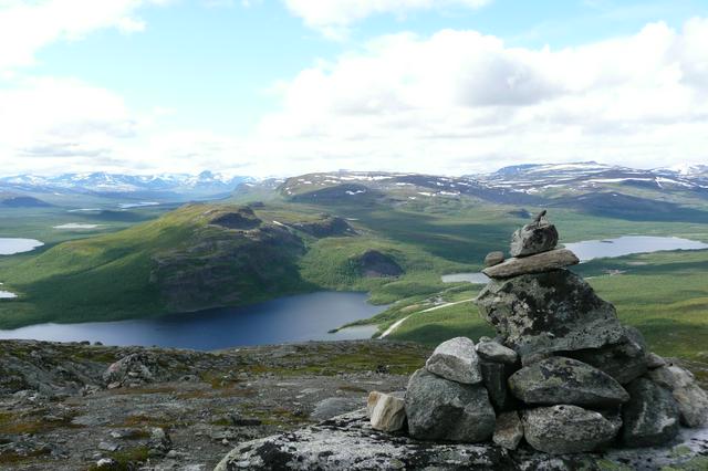
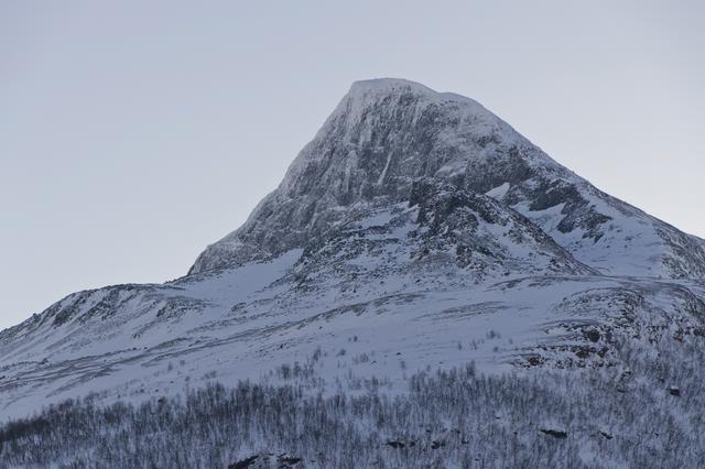
- Saana. Probably the most well-known mountain in Finland. A 4-kilometre trail and the longest stairs in Finland take you to the very top of the 1000-meter Arctic hill with a weird shape. Coming down is hard on your ankles, turn back in time if you feel you might not make it.
- Kilpisjärvi Nature Centre, Käsivarrentie 14145, +358 20-564-7990. 15.6–30.9 daily 9–17, 1.3–8.5 shorter hours, closed off season. Information on the wilderness area, the Saana fell and the Malla nature reserve by the tripoint. Maps (also for nearby areas in Norway and Sweden), fishing permits, snowmobile track permits, reservation and key of reservation huts, information on available service in the region and general advice. Exhibition about local nature and culture. Short audiovisual slide shows. Local handicrafts, products, books and souvenirs for sale. Children’s play corner. Accessible by wheelchair. Groups wanting guiding should book in advance. Free. Guiding €45 per group per hour.
- Kilpisjärvi Biological Station, Käsivarrentie 14622, +358 29-414-0340. Research station of University of Helsinki, founded 1964.
- Tsahkaljoki Falls Along a 2 km trail starting at Hotel Kilpis.
- Muotkatakka. The highest point of the Finnish national road network, 565.8 m above sea level. A Lapland War memorial by the nearby rest spot.
- Iitto mire reserve. Mire reserve with palsa bogs, i.e. bogs with frost mounds. 500 m nature trail.
- Northern Lights. Kilpisjärvi is known in Finland for its clean mountain air. The nearest town in Finland is 100 km away, and Norway lies behind the Scandinavian Mountains. Kilpisjärvi is perfect to watch Northern Lights due to the altitude, polar nights, dry weather (significantly dryer than Norway) and no light pollution. The 200 km long route along the Finnish-Swedish border between Kilpisjärvi and Muonio is sometimes called The Northern Lights Route.
Saana. Probably the most well-known mountain in Finland. A 4-kilometre trail and the longest stairs in Finland take you to the very top of the 1000-meter Arctic hill with a weird shape. Coming down is hard on your ankles, turn back in time if you feel you might not make it.
Kilpisjärvi Nature Centre, Käsivarrentie 14145, +358 20-564-7990. 15.6–30.9 daily 9–17, 1.3–8.5 shorter hours, closed off season. Information on the wilderness area, the Saana fell and the Malla nature reserve by the tripoint. Maps (also for nearby areas in Norway and Sweden), fishing permits, snowmobile track permits, reservation and key of reservation huts, information on available service in the region and general advice. Exhibition about local nature and culture. Short audiovisual slide shows. Local handicrafts, products, books and souvenirs for sale. Children’s play corner. Accessible by wheelchair. Groups wanting guiding should book in advance. Free. Guiding €45 per group per hour.
Kilpisjärvi Biological Station, Käsivarrentie 14622, +358 29-414-0340. Research station of University of Helsinki, founded 1964.
Tsahkaljoki Falls Along a 2 km trail starting at Hotel Kilpis.
Muotkatakka. The highest point of the Finnish national road network, 565.8 m above sea level. A Lapland War memorial by the nearby rest spot.
Iitto mire reserve. Mire reserve with palsa bogs, i.e. bogs with frost mounds. 500 m nature trail.
[[Northern Lights]]. Kilpisjärvi is known in Finland for its clean mountain air. The nearest town in Finland is 100 km away, and Norway lies behind the Scandinavian Mountains. Kilpisjärvi is perfect to watch Northern Lights due to the altitude, polar nights, dry weather (significantly dryer than Norway) and no light pollution. The 200 km long route along the Finnish-Swedish border between Kilpisjärvi and Muonio is sometimes called The Northern Lights Route.
- The mountain Saana is a popular destination, not only among hikers but anyone visiting Kilpisjärvi. Saana has got an unmistakeable profile and it is situated just a few kilometres from Kilpisjärvi. Although there is a trail all the way to the top, the climb is considerable. Reserve enough time (coming down is what is hardest on your ankles) and have suitable footwear (sport shoes are OK). The Saana trailhead. is at the hostel.
- Saana Nature. 5 km nature trail from Kilpisjärvi showing nature at the west side of Saana.
- Saana Trail. 8 km trail leading from Kilpisjärvi to the top of Saana and back. Features the longest set of steps in Finland.
- Hiking trail Tsahkaljärvi–Saanajärvi–Saana, start near hotel Kilpis.
- The annual Kilpisjärvi Midsummer skiing event is held at the Saana fell.
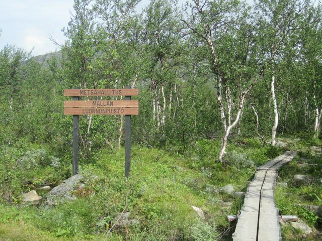
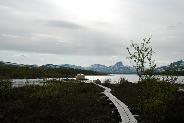
- Malla nature reserve. with the Three Border Point. (Kolmen valtakunnan rajapyykki in Finnish, Treriksröset in Swedish, Treriksrøysa in Norwegian), where the national borders of Finland, Sweden and Norway collide. The tripoint is located in Golddaluokta, 10–20 km from Kilpisjärvi. It is reachable by boat and a 3 km hike or by a longer hike through the nature reserve. At lake Kuohkimajärvi (Sámi: Guohkkemašjávri) half a kilometre from the tripoint there is the Kuohkimajärvi open wilderness hut. (6 persons), a reservation hut and a campfire site. Note that this is a strict nature reserve: e.g. deviating from the marked trails (except in winter), causing erosion, picking berries, camping (except at the wilderness hut) and disturbing wildlife is forbidden.
- Boat trip. If there are enough passengers the boat will make three daily return trips (10:00, 14:00, 18:00). The season is usually from Midsummer to mid September. Return trip by boat from Kilpisjärvi to Koltalahti and 3 km hike to the tripoint: the boat trip over Kilpisjärvi takes half an hour (with nice views) and the boat waits two hours while the passengers visit the tripoint.
- Malla trail. Hike through Malla nature reserve: 11 km one way, either way possible with boat, but using it for return, make sure it makes the trip. The trail starts at an information board (also in English) by a parking area in the north end of the village. After 2,5 km there is a detour to Pikku-Malla ("small Malla"), with nice views. The 7 km return trip to Pikku-Malla is through easy terrain in fell birch forest and over fell heath. Further up at the Iso-Malla hillside there is rough terrain (boulder, willow shrubs) and there are fords, normally easy but possibly difficult at high waters. Most advice about wilderness hikes in Lapland apply (spring comes late, be prepared for bad weather and weak phone connectivity, tell about your plans etc.). The trail shows most of the typical terrain types. As the Scandinavian bedrock of Malla differs from the Finnish, there are also many rare plant species.
- One can also return via Norway: from Goldahytta hut 3 km away a trail goes west of Malla to E8 1 km from the Finnish border.
- In spring there is an 11 km maintained skiing track through the nature reserve and a 10 km skiing track over lake Kilpisjärvi, both leading to the tripoint.
- The snowmobile route Victorialeden (over Kilpisjärvi) goes to the tripoint on the Swedish side of the border, thus avoiding the nature reserve, where vehicle driving is forbidden. Most snowmobile tracks require paying a fee, but this route is part of the national road infrastructure (according to Finnish law) and thus free.
- From the tripoint hiking trails lead to the Swedish and Norwegian fells. Goldahytta hut. is 3 km from the tripoint, Gappohytta hut. below the Paras fell. (Sámi: Bárrás) a further 14 km away (both locked with the DNT key). From here the trail leads to the Pältsa hut. at Pältsa. in Sweden (12 km; the hut was used by the Norwegian resistance during WW2) and back to Koltalahti (14 km). Instead continuing by Nordkalottleden one can extend the hike as much as one likes.
- Salmivaara Trail (2 km) between the lakes Kilpisjärvi and Ala-Kilpisjärvi. Start by the Nature Centre.
- Hike to Ailakkajärvi (10 km). Start at Peera. by E8, some 17 km south of Kilpisjärvi. Ailakkajärvi open wilderness hut. (6 persons) at the lake shore. There is a path back (7 km) by Ailakkajoki to Ailakkalahti. at E8, 5 km from Kilpisjärvi, through a part of the nature conservation programme area Käsivarren tunturijärvet ("Käsivarsi mountain lakes").
- Halti. is with its 1328m the highest mountain of Finland. It's a popular destination among hikers, a long way from any road in Käsivarsi Wilderness Area. It's situated some 50 km north from Kilpisjärvi, which is the nearest village. There is a marked trail, wilderness huts and a few bridges, but the terrain is rough for Finland and conditions really harsh if the weather turns bad. Appoint a guide unless you have some serious hiking experience. It is recommended that you reserve at least a week for a return trip. To avoid coming back the same way you can continue to Norway instead. The recommended route from Halti to E8 in Norway (23 km) is more demanding than the Finnish trail.
- Popular winter activities include cross-country skiing, snow shoe hiking, snowmobiling and ice fishing.
- There are many cross-country skiing tracks around Kilpisjärvi, also a short one with lights.
- Kilpissafarit, +358 40 516 1952. Fell and fishing tours, snowmobiles for rent.
The mountain Saana is a popular destination, not only among hikers but anyone visiting Kilpisjärvi. Saana has got an unmistakeable profile and it is situated just a few kilometres from Kilpisjärvi. Although there is a trail all the way to the top, the climb is considerable. Reserve enough time (coming down is what is hardest on your ankles) and have suitable footwear (sport shoes are OK). The Saana trailhead. is at the hostel.
- Saana Nature. 5 km nature trail from Kilpisjärvi showing nature at the west side of Saana.
- Saana Trail. 8 km trail leading from Kilpisjärvi to the top of Saana and back. Features the longest set of steps in Finland.
- Hiking trail Tsahkaljärvi–Saanajärvi–Saana, start near hotel Kilpis.
- The annual Kilpisjärvi Midsummer skiing event is held at the Saana fell.
Malla nature reserve. with the Three Border Point. (Kolmen valtakunnan rajapyykki in Finnish, Treriksröset in Swedish, Treriksrøysa in Norwegian), where the national borders of Finland, Sweden and Norway collide. The tripoint is located in Golddaluokta, 10–20 km from Kilpisjärvi. It is reachable by boat and a 3 km hike or by a longer hike through the nature reserve. At lake Kuohkimajärvi (Sámi: Guohkkemašjávri) half a kilometre from the tripoint there is the Kuohkimajärvi open wilderness hut. (6 persons), a reservation hut and a campfire site. Note that this is a strict nature reserve: e.g. deviating from the marked trails (except in winter), causing erosion, picking berries, camping (except at the wilderness hut) and disturbing wildlife is forbidden.
- Boat trip. If there are enough passengers the boat will make three daily return trips (10:00, 14:00, 18:00). The season is usually from Midsummer to mid September. Return trip by boat from Kilpisjärvi to Koltalahti and 3 km hike to the tripoint: the boat trip over Kilpisjärvi takes half an hour (with nice views) and the boat waits two hours while the passengers visit the tripoint.
- Malla trail. Hike through Malla nature reserve: 11 km one way, either way possible with boat, but using it for return, make sure it makes the trip. The trail starts at an information board (also in English) by a parking area in the north end of the village. After 2,5 km there is a detour to Pikku-Malla ("small Malla"), with nice views. The 7 km return trip to Pikku-Malla is through easy terrain in fell birch forest and over fell heath. Further up at the Iso-Malla hillside there is rough terrain (boulder, willow shrubs) and there are fords, normally easy but possibly difficult at high waters. Most advice about wilderness hikes in Lapland apply (spring comes late, be prepared for bad weather and weak phone connectivity, tell about your plans etc.). The trail shows most of the typical terrain types. As the Scandinavian bedrock of Malla differs from the Finnish, there are also many rare plant species.
- One can also return via Norway: from Goldahytta hut 3 km away a trail goes west of Malla to E8 1 km from the Finnish border.
- In spring there is an 11 km maintained skiing track through the nature reserve and a 10 km skiing track over lake Kilpisjärvi, both leading to the tripoint.
- The snowmobile route Victorialeden (over Kilpisjärvi) goes to the tripoint on the Swedish side of the border, thus avoiding the nature reserve, where vehicle driving is forbidden. Most snowmobile tracks require paying a fee, but this route is part of the national road infrastructure (according to Finnish law) and thus free.
From the tripoint hiking trails lead to the Swedish and Norwegian fells. Goldahytta hut. is 3 km from the tripoint, Gappohytta hut. below the Paras fell. (Sámi: Bárrás) a further 14 km away (both locked with the DNT key). From here the trail leads to the Pältsa hut. at Pältsa. in Sweden (12 km; the hut was used by the Norwegian resistance during WW2) and back to Koltalahti (14 km). Instead continuing by Nordkalottleden one can extend the hike as much as one likes.
From the tripoint hiking trails lead to the Swedish and Norwegian fells. Goldahytta hut. is 3 km from the tripoint, Gappohytta hut. below the Paras fell. (Sámi: Bárrás) a further 14 km away (both locked with the DNT key). From here the trail leads to the Pältsa hut. at Pältsa. in Sweden (12 km; the hut was used by the Norwegian resistance during WW2) and back to Koltalahti (14 km). Instead continuing by Nordkalottleden one can extend the hike as much as one likes.
From the tripoint hiking trails lead to the Swedish and Norwegian fells. Goldahytta hut. is 3 km from the tripoint, Gappohytta hut. below the Paras fell. (Sámi: Bárrás) a further 14 km away (both locked with the DNT key). From here the trail leads to the Pältsa hut. at Pältsa. in Sweden (12 km; the hut was used by the Norwegian resistance during WW2) and back to Koltalahti (14 km). Instead continuing by Nordkalottleden one can extend the hike as much as one likes.
From the tripoint hiking trails lead to the Swedish and Norwegian fells. Goldahytta hut. is 3 km from the tripoint, Gappohytta hut. below the Paras fell. (Sámi: Bárrás) a further 14 km away (both locked with the DNT key). From here the trail leads to the Pältsa hut. at Pältsa. in Sweden (12 km; the hut was used by the Norwegian resistance during WW2) and back to Koltalahti (14 km). Instead continuing by Nordkalottleden one can extend the hike as much as one likes.
From the tripoint hiking trails lead to the Swedish and Norwegian fells. Goldahytta hut. is 3 km from the tripoint, Gappohytta hut. below the Paras fell. (Sámi: Bárrás) a further 14 km away (both locked with the DNT key). From here the trail leads to the Pältsa hut. at Pältsa. in Sweden (12 km; the hut was used by the Norwegian resistance during WW2) and back to Koltalahti (14 km). Instead continuing by Nordkalottleden one can extend the hike as much as one likes.
Salmivaara Trail (2 km) between the lakes Kilpisjärvi and Ala-Kilpisjärvi. Start by the Nature Centre.
Hike to Ailakkajärvi (10 km). Start at Peera. by E8, some 17 km south of Kilpisjärvi. Ailakkajärvi open wilderness hut. (6 persons) at the lake shore. There is a path back (7 km) by Ailakkajoki to Ailakkalahti. at E8, 5 km from Kilpisjärvi, through a part of the nature conservation programme area Käsivarren tunturijärvet ("Käsivarsi mountain lakes").
Hike to Ailakkajärvi (10 km). Start at Peera. by E8, some 17 km south of Kilpisjärvi. Ailakkajärvi open wilderness hut. (6 persons) at the lake shore. There is a path back (7 km) by Ailakkajoki to Ailakkalahti. at E8, 5 km from Kilpisjärvi, through a part of the nature conservation programme area Käsivarren tunturijärvet ("Käsivarsi mountain lakes").
Hike to Ailakkajärvi (10 km). Start at Peera. by E8, some 17 km south of Kilpisjärvi. Ailakkajärvi open wilderness hut. (6 persons) at the lake shore. There is a path back (7 km) by Ailakkajoki to Ailakkalahti. at E8, 5 km from Kilpisjärvi, through a part of the nature conservation programme area Käsivarren tunturijärvet ("Käsivarsi mountain lakes").
Halti. is with its 1328m the highest mountain of Finland. It's a popular destination among hikers, a long way from any road in [[Käsivarsi Wilderness Area]]. It's situated some 50 km north from Kilpisjärvi, which is the nearest village. There is a marked trail, wilderness huts and a few bridges, but the terrain is rough for Finland and conditions really harsh if the weather turns bad. Appoint a guide unless you have some serious hiking experience. It is recommended that you reserve at least a week for a return trip. To avoid coming back the same way you can continue to Norway instead. The recommended route from Halti to E8 in Norway (23 km) is more demanding than the Finnish trail.
Popular winter activities include [[cross-country skiing]], snow shoe hiking, snowmobiling and ice fishing.
- There are many cross-country skiing tracks around Kilpisjärvi, also a short one with lights.
- Kilpissafarit, +358 40 516 1952. Fell and fishing tours, snowmobiles for rent.
In addition to Euros, Swedish and Norwegian kronor are usable at least at the Kilpishalli store, which also handles money exchange.
Credit cards are probably usable at least at the hotel and Kilpishalli, not necessarily at all businesses.
The nearest ATM is in Hetta (175 km). You can get cash at Kilpishalli.
There is a service and fuel station by Kilpishalli.
- K-Market Kilpishalli, Käsivarrentie 14205, +358 16 537747. Mon–Thu 10–18, Fri 10–20, Sat 10–19, Sun 11–18. Grocery store with wide range of products.
K-Market Kilpishalli, Käsivarrentie 14205, +358 16 537747. Mon–Thu 10–18, Fri 10–20, Sat 10–19, Sun 11–18. Grocery store with wide range of products.
See also Sleep below.
- Cafe Restaurant Ida-Sofie, Käsivarrentie 14205, +358 16 537-790. 12–18. The best restaurant in town. Scenic restaurant with views to the Saana and the lake.
Cafe Restaurant Ida-Sofie, Käsivarrentie 14205, +358 16 537-790. 12–18. The best restaurant in town. Scenic restaurant with views to the Saana and the lake.
The postal code is 99490 Kilpisjärvi.
Mobile phone connectivity is probably weak in many locations. Try to have the antenna at Saana in sight to get a connection.
- The Nordkalottleden long distance hiking route, via Halti to Kautokeino in Norway or via the tripoint to Abisko and further on over the Narvik fells and through Laponia. The legs around Kilpisjärvi coincide with the E1 trail from Sicily to Nordkapp.
- Hiking in the backcountry of Käsivarsi Wilderness Area.
The [[Nordkalottleden]] long distance hiking route, via Halti to [[Kautokeino]] in Norway or via the tripoint to [[Abisko]] and further on over the Narvik fells and through [[Laponia]]. The legs around Kilpisjärvi coincide with the [[long distance walking in Europe|E1 trail]] from [[Sicily]] to [[Nordkapp]].
Hiking in the backcountry of [[Käsivarsi Wilderness Area]].