
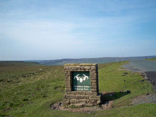
The Yorkshire Dales are a scenic area of limestone hills and valleys in North Yorkshire in the north of England. Much of the area falls within the Yorkshire Dales National Park, which extends into neighbouring Cumbria and Lancashire. The area includes Nidderdale though this is not part of the Park.
A "dale" simply means a valley, so it's a very common component of a place-name, in Yorkshire and elsewhere. The Dales described here are those in the Pennines, north of Skipton and south of Kirkby Stephen, and the hills between them. Their terrain is exposed limestone or karst country, scenically sculpted by glaciation and by water action. Similar terrain and scenery is found at the southern end of the Pennines, the Peak District, while the area between is overlain by tough millstone and looks quite different: bleak, boggy and infertile.
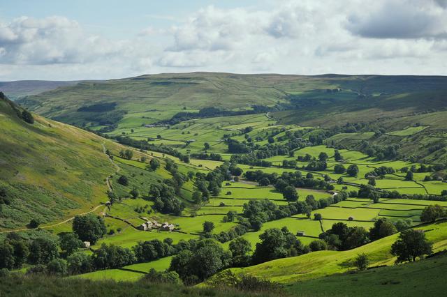
Rivers course down the dales, mostly flowing east, but Ribblesdale and Lonsdale flow south then west to the Irish Sea. As each river leaves the limestone hills, it comes into gentler rolling country then low plains, pastoral and bucolic. Names such as "Wharfedale" and "Nidderdale" are often extended to these broad valleys and meander plains, but they don't have classic Dales scenery, and they're only considered on this page to the extent that they have transport routes and amenities relevant to visitors to the Dales.
The area is at low altitude by European mountain standards, and is fertile, with cattle farming on the lower ground and sheep on the hills. In Norman times monasteries were established, eg at Bolton Priory and Fountains Abbey, that controlled much of this land and promoted agriculture. Later centuries saw the building of castles such as Castle Bolton and hunting lodges such as Barden Tower. The Industrial era brought lead and coal mining, quarrying, and the construction of roads and railways. This, plus new housing, was economically necessary but potentially ruinous to the area's natural beauty, so in 1954 the Yorkshire Dales National Park was created. Nidderdale wasn't included, but was separately protected in 1994 by designation as an "Area of Outstanding Natural Beauty" (AONB). In 2016 the National Park was considerably extended westwards, almost to the M6, so it now includes Lonsdale.
The Park borders upon several other protected areas: Nidderdale AONB as mentioned to the southeast, Lake District National Park to the west, Forest of Bowland AONB to the southwest, and North Pennines AONB to the north. So a huge tract of northern England is now within a joined-up protected habitat where development is tightly controlled. So maybe they could re-introduce bears, wolves, and other early denizens? Realistically not those, the combined area is still too small and too populated, but water voles and hazel dormice have been re-introduced. You've got to start small.
There are no park fees or road tolls in any of these areas. The usual charges apply for parking, campsites, and admission to attractions. Permits are required (as in the rest of the UK) for fishing, hunting, etc. Fishing licences are available at Post Offices.
As with the rest of the UK, winter (October–March) can be wet, cold (−5°C–15°C) and windy, and summer (June–August) can be warm and sunny (18°C–28°C). However there are no guarantees so it is quite possible for rainy weather in summer and moderate weather in winter.
The principal dales are Wharfedale, Wensleydale, Swaledale, Nidderdale, Ribblesdale, Airedale and Lonsdale, each with a distinct character. Many smaller dales feed into these.
- Wharfedale is very accessible from Leeds so it gets busy on summer weekends. Turn off A59 onto B6160 at Bolton Bridge to Bolton Abbey.. Sights here are the ruined Priory (it wasn't actually an Abbey), and the torrent of The Strid, where the River Wharfe rips between rocks. (So called because you could almost stride between river banks - but not quite, and that's the end of you.) Road and valley continue up through Burnsall, Grassington, Conistone (where Littondale joins), Kettlewell, Starbotton and Buckden.
Above Buckden the valley divides. The main valley of the Wharfe, feeding in from the west, is called Langstrothdale above here. The village of Hubberholme has a delightful church. The lane eventually crosses the hills to Hawes in Wensleydale. The lesser valley, feeding in from the northeast, is the line of the B6160 over to Bishopdale, entering Wensleydale near Aysgarth.
- Wensleydale is named for the village of Wensley, not for its river the Ure. It's in two parts: the upper "dale-like" reaches (on A684) are above Aysgarth., with a scenic waterfall. The dale runs up through Askrigg and Hawes, where it's joined by Fossdale tumbling over Hardrow Force waterfall, and Cotterdale. Above is Garsdale and the moors over to Dentdale, Cumbria and the Lune Valley. Downstream from Aysgarth, the river leaves the Park to flow through softer country alongside A6108 past Leyburn, Middleham (with its castle), Jervaulx Abbey and Masham; then it meanders south towards Ripon.
- Swaledale, north of Wensleydale, starts just above Richmond.; Easby Abbey is nearby. The valley and A6108 / B6270 ascend east through Keld, Thwaite, Gunnerside and Reeth. A lane from Thwaite crosses the pot-holed wilds of "Butter Tubs" to Hawes.
- Nidderdale is not within the National Park, but is similarly protected as an Area of Outstanding Natural Beauty. It's to the east, with the River Nidd rising in hills above Scar House Reservoir, then flowing south through Middlesmoor, Lofthouse and Ramsgill to enter Gouthwaite Reservoir. From there it flows on to Pateley Bridge. and Summerbridge. On the hills north of Summerbridge are Brimham Rocks. The river then turns west and leaves the dales, meandering through farmland past Knaresborough to join the Ouse near York. There's a good road up the dale, B6165 (with a bus service) up as far as Pateley Bridge then a lane up to Lofthouse. The lane then climbs over the moors east towards Masham.
- Ribblesdale together with Airedale forms the "Aire Gap" through the Pennines, a historically important low-level route. It's traversed by main roads with bus services, and railway lines, so it's very accessible. These roads are also a route from the Yorkshire cities to the Lake District, so they become congested on summer weekends. From Yorkshire, approach along A65 past Skipton. and Gargrave. From the west follow M65 then A682 onto A65. Attractive limestone scenery starts above Settle, with valley, B6479 and railway climbing north to Stainforth and Horton-in-Ribblesdale. Horton itself is marred by quarrying, but above are the brooding "Three Peaks" of Whernside, Ingleborough and Pen-y-Ghent, sheep-farms enclosed with drystone walls, and the railway spanning the Ribbleshead viaduct. It's classic country for hiking, caving and pot-holing, with the extensive Alum Pot system.
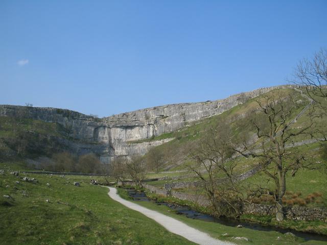
- The lower section of Airedale below Keighley is industrial, but the upper reaches are very attractive. Branch off A65 at Gargrave and follow the lane north past Airton to Malham.. Above here are spectacular Malham Cove, Gordale Scar, and Janet's Foss.
- Lonsdale became part of the Park when this was extended westwards in 2016. This lies in Cumbria and is usually accessed via Kirkby Lonsdale.. A683 runs up the valley to Sedbergh then crosses the moors to Kirkby Stephen; minor roads stay in the Lune valley and parallel the M6 through the Lune Gorge to Tebay. Much of the area has millstone bedrock, but limestone karst scenery is found in the northern reaches around Great Asby Scar.
Wharfedale is very accessible from Leeds so it gets busy on summer weekends. Turn off A59 onto B6160 at Bolton Bridge to Bolton Abbey.. Sights here are the ruined Priory (it wasn't actually an Abbey), and the torrent of The Strid, where the River Wharfe rips between rocks. (So called because you could almost stride between river banks - but not quite, and that's the end of you.) Road and valley continue up through Burnsall, [[Grassington]], Conistone (where Littondale joins), Kettlewell, Starbotton and Buckden.
Above Buckden the valley divides. The main valley of the Wharfe, feeding in from the west, is called Langstrothdale above here. The village of Hubberholme has a delightful church. The lane eventually crosses the hills to Hawes in Wensleydale. The lesser valley, feeding in from the northeast, is the line of the B6160 over to Bishopdale, entering Wensleydale near Aysgarth.
Wensleydale is named for the village of Wensley, not for its river the Ure. It's in two parts: the upper "dale-like" reaches (on A684) are above Aysgarth., with a scenic waterfall. The dale runs up through Askrigg and [[Hawes]], where it's joined by Fossdale tumbling over Hardrow Force waterfall, and Cotterdale. Above is Garsdale and the moors over to Dentdale, Cumbria and the Lune Valley. Downstream from Aysgarth, the river leaves the Park to flow through softer country alongside A6108 past Leyburn, Middleham (with its castle), Jervaulx Abbey and Masham; then it meanders south towards [[Ripon]].
Swaledale, north of Wensleydale, starts just above Richmond.; Easby Abbey is nearby. The valley and A6108 / B6270 ascend east through Keld, Thwaite, Gunnerside and Reeth. A lane from Thwaite crosses the pot-holed wilds of "Butter Tubs" to Hawes.
Nidderdale is not within the National Park, but is similarly protected as an Area of Outstanding Natural Beauty. It's to the east, with the River Nidd rising in hills above Scar House Reservoir, then flowing south through Middlesmoor, Lofthouse and Ramsgill to enter Gouthwaite Reservoir. From there it flows on to Pateley Bridge. and Summerbridge. On the hills north of Summerbridge are Brimham Rocks. The river then turns west and leaves the dales, meandering through farmland past [[Knaresborough]] to join the Ouse near York. There's a good road up the dale, B6165 (with a bus service) up as far as Pateley Bridge then a lane up to Lofthouse. The lane then climbs over the moors east towards Masham.
Ribblesdale together with Airedale forms the "Aire Gap" through the Pennines, a historically important low-level route. It's traversed by main roads with bus services, and railway lines, so it's very accessible. These roads are also a route from the Yorkshire cities to the Lake District, so they become congested on summer weekends. From Yorkshire, approach along A65 past Skipton. and Gargrave. From the west follow M65 then A682 onto A65. Attractive limestone scenery starts above [[Settle]], with valley, B6479 and railway climbing north to Stainforth and Horton-in-Ribblesdale. Horton itself is marred by quarrying, but above are the brooding "Three Peaks" of Whernside, Ingleborough and Pen-y-Ghent, sheep-farms enclosed with drystone walls, and the railway spanning the Ribbleshead viaduct. It's classic country for hiking, caving and pot-holing, with the extensive Alum Pot system.
The lower section of Airedale below Keighley is industrial, but the upper reaches are very attractive. Branch off A65 at Gargrave and follow the lane north past Airton to Malham.. Above here are spectacular Malham Cove, Gordale Scar, and Janet's Foss.
Lonsdale became part of the Park when this was extended westwards in 2016. This lies in [[Cumbria]] and is usually accessed via Kirkby Lonsdale.. A683 runs up the valley to Sedbergh then crosses the moors to Kirkby Stephen; minor roads stay in the Lune valley and parallel the M6 through the Lune Gorge to Tebay. Much of the area has millstone bedrock, but limestone karst scenery is found in the northern reaches around Great Asby Scar.
- Aysgarth Falls. A set of waterfalls and rock formations in lush woodland.
- Bolton Abbey. Beautiful riverside abbey in picturesque location at the foot of the Dales hills.
- Brimham Rocks, Summerbridge HG3 4DW, +44 1423 780688. 08:00-dusk. Millstone is a very tough rock which south of the Dales forms the main bedrock, creating boggy plateaus. Most of the Dales are limestone, but here and there are teetering millstone outcrops. Ice makes it crack vertically and horizontally, so it looks like giants' architecture, or their stacked crockery. Brimham Rocks are the best example, others are Plumpton Rocks near Wetherby, and Almscliff Crag near Otley.
Aysgarth Falls. A set of waterfalls and rock formations in lush woodland.
Bolton Abbey. Beautiful riverside abbey in picturesque location at the foot of the Dales hills.
Brimham Rocks, Summerbridge HG3 4DW, +44 1423 780688. 08:00-dusk. Millstone is a very tough rock which south of the Dales forms the main bedrock, creating boggy plateaus. Most of the Dales are limestone, but here and there are teetering millstone outcrops. Ice makes it crack vertically and horizontally, so it looks like giants' architecture, or their stacked crockery. Brimham Rocks are the best example, others are Plumpton Rocks near Wetherby, and Almscliff Crag near Otley.
- Walk as far or as little as you like. As with other areas of natural beauty, anything within ten minutes of the car park may feel like a suburban picnic spot, but anything beyond suddenly propels you miles from anywhere. Several long-distance trails cross the area:
The Pennine Way from the south crosses A65 at Gargrave, follows the Aire Valley north to Malham and onto the limestone tops - this section around Malham Tarn is the most scenic of the entire path - then veers west over Pen-y-Ghent to Horton-in-Ribblesdale. From there it's practically straight north to Hawes. North again, the route leaves the Park at Tan Hill to head into the North Pennines and Teesdale.
The Dales Way runs the length of Wharfedale past Bolton Abbey to Grassington, Kettlewell and Hibberholme, into Langstrothdale and over into Cumbria.
- The Three Peaks can be admired from the roadside, but do climb them if the weather's decent, there's nothing difficult. The three are
Pen-y-Ghent. (2277 feet, 694 m) shaped like the prow of a battleship bearing down on you.
Ingleborough. (2372 feet, 723 m) with a distinct layered appearance, and pierced by the chasm of Juniper Gulf.
Whernside. (2415 feet, 736 m) is the highest point in North Yorkshire, sharing its summit with Cumbria.
- Wensleydale Railway. This runs from Leeming Bar near Northallerton to Bedales, Leyburn and Redmire. It's often steam-hauled (check timetable for steam days) and you can even arrange to work alongside the driver.
Walk as far or as little as you like. As with other areas of natural beauty, anything within ten minutes of the car park may feel like a suburban picnic spot, but anything beyond suddenly propels you miles from anywhere. Several long-distance trails cross the area:
The Pennine Way from the south crosses A65 at Gargrave, follows the Aire Valley north to Malham and onto the limestone tops - this section around Malham Tarn is the most scenic of the entire path - then veers west over Pen-y-Ghent to Horton-in-Ribblesdale. From there it's practically straight north to Hawes. North again, the route leaves the Park at Tan Hill to head into the North Pennines and Teesdale.
The Dales Way runs the length of Wharfedale past Bolton Abbey to Grassington, Kettlewell and Hibberholme, into Langstrothdale and over into Cumbria.
The Three Peaks can be admired from the roadside, but do climb them if the weather's decent, there's nothing difficult. The three are
Pen-y-Ghent. (2277 feet, 694 m) shaped like the prow of a battleship bearing down on you.
Wensleydale Railway. This runs from Leeming Bar near Northallerton to Bedales, Leyburn and Redmire. It's often steam-hauled (check timetable for steam days) and you can even arrange to work alongside the driver.
The Dales is not known as a major shopping destination, but many of the towns and villages have a range of small tourist and craft shops as well as local amenities. The markets can be treasure troves of local produce. The nearest major shopping city is Leeds, but nearer-by Skipton and Harrogate have a selection of shops.
- Hawes. Market, rope-maker's shop and a few good antique shops.
- The Old Sweet Shop, Market Pl, Hawes. A delicious wonderland filled with all kinds of sweets!
Hawes. Market, rope-maker's shop and a few good antique shops.
The Old Sweet Shop, Market Pl, Hawes. A delicious wonderland filled with all kinds of sweets!
Find a traditional Yorkshire pub in any of the numerous villages, for a fair value hearty meal. Traditional favourite is Roast Beef and Yorkshire Pudding.
The local Wensleydale cheese... traditionally served with apple pie.
- The Angel Inn, Back Ln, Hetton, +44 1756 730263.
The Angel Inn, Back Ln, Hetton, +44 1756 730263.
There are a variety of local beers to try in any local pub. Just a short journey westwards from the A1, main arterial road north, lies the village of Wensley. This village gives its name to the local dale and is a favourite spot in the whole of the Dales. Whilst here, drop into the local pub (there is only one) to sample the brews from the local Wensleydale Brewery, particularly the "Poacher" and "Gamekeeper". These are drinks to die for! But, take it easy if you want to be able to enjoy the scenery afterwards! These are brews of around 5 per cent. You can sit outside if the weather is good or sit inside and enjoy a pub interior that owes nothing to modern `drink-factory` design.
The Yorkshire Dales Brewing Company makes a variety of beers, taking inspiration from both Yorkshire and abroad. A number of pubs have a house beer brewed by the company. The brewery can be found in Askrigg, location of the TV series All creatures Great and Small.
There is little crime in the Dales except for petty theft from cars so leave valuables hidden. Take precautions against the weather if going out walking.
Beware the Bolton Strid - this innocuous-looking stream is far more dangerous than it appears, so don't go for a swim.
- Leeds - the largest city in Yorkshire and is easily accessible, by road or rail.
- York - historic and is easily accessible, by road or rail.
[[Leeds]] - the largest city in Yorkshire and is easily accessible, by road or rail.
[[York]] - historic and is easily accessible, by road or rail.